Web maps are built by selecting a basemap, then adding data layers from services and files. Layers can come from many different sources including ArcGIS Online, GIS services (including OGC WMS services), and Web and local file-based data like CSV files, shapefiles, KML, and more.
Types of Layers
Layers that you can use directly in your map can be referenced data layers, or data layers stored within the map. Referenced layers are available from ArcGIS Online, from your network, or from other servers available via the internet. Referenced layer types include the following:
- Map service
- Feature service
- Image service
- KML
- OGC WMS
- CSV
You can also import local data from files on your computer, and create editable layers (e.g. map notes) that let you add data interactively to your map. These layer types are stored within your map, and include the following:
- Delimited text file (.csv and .txt)
- Shapefile (.zip)
- GPS file (.gpx)
- Editable layers created in the ArcGIS.com map viewer (map notes)
While there are common properties, each layer type also has unique properties and capabilities, including the order in which they appear in the map contents.
See About working with layers for more details.
Drawing order
Layers above others in Contents draw on top of layers lower down in the list. This is important when you are designing your map so that you provide your audience with the best possible experience. You’ll want to minimize the chance that important symbols or labels are obscured by less important aspects of your map.
Though there isn’t a visual indication, the web map’s layers are are separated into several sections in Contents based on the layer type. While you can reorder layers within each section, it’s not possible to move layers between sections or change the order of the sections themselves. The sections and their drawing order are as follows:
- Map notes
- KML & WMS
- Feature services and imported file-based data (SHP, CSV, TXT, GPX)
- Map & image services
- Basemap
See Organizing layers for more information.
Map Notes
Editable feature layers in your map (map notes) are always at the top of your contents and draw on top of all other layers. These layers can be re-ordered with respect to other map notes layers, but cannot be moved below other layer types.
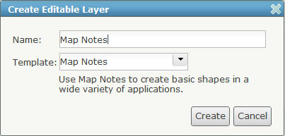
These layers live within the web map where they were created, and not as stand-alone layers that can be added to other web maps. They can be seen by anyone who the web map is shared with, but can only be modified by the owner of the web map (unless another copy is saved).
See Creating editable layers for more information.
KML & WMS
KML and WMS layers are in the second section. They appear in the order in which they are added, with the most recent at the top. They cannot be rearranged, so a little forethought will help get these layers organized in the desired way.
Currently you cannot set a visibility range on KML or WMS layers. Also note that KML layers will appear in the web map legend (unless you choose to hide them), but WMS layers do not.
See About KML and About OGC WMS for more information.
Feature Layers
The next section of layers contains feature layers, which includes feature services as well as any file-based data sources that you may have added to the map. Feature services may be served from ArcGIS for Server or hosted in your ArcGIS Online subscription account.
If you have shared the layer as an ArcGIS Online item, then changes you make in the layer configuration can be saved with the layer, ensuring that others using your layer will see the same pop-up configuration and symbols.
The geometries for file-based data (shapefiles, CSV, TXT, and GPX) are stored as JSON in the web map description and therefore live within the web map. This is in contrast to feature services, which are served from a remote server.
Since feature layers (both feature services and file-based sources) are drawn by the browser you can adjust their symbols in the web map. Other capabilities for feature layers include setting the transparency and visibility range and changing the layer name.
Because feature layers are managed by the browser, it’s important to be conscious of the number and complexity of features being drawn. You may want to set a visibility range so that these layers only draw at scales where a reasonable number of features are being drawn at once (also reducing map clutter). You can improve performance of feature layers by using scale dependencies, and also by simplifying the geometries for line and polygon layers when you import them or before you publish them.
Note that the management of features is dependent on the browser, and different browsers will yield different performance results.
For more information see:
Map and Image Services
The next section of layers contains map services and image services. These services may be published using ArcGIS for Server (and be either dynamic or cached), or can be published as hosted tile services from ArcGIS Online.
You can rename these layers, adjust their transparency, and define pop-ups on each map service sublayer. Sublayers can be turned on and off independently but cannot be re-ordered. Symbols for these services cannot be changed, because these layers are “pre-rendered” as tiles on a remote server, and sent to the browser.
As with feature layers, you have the option to save configuration properties back to the item if you have shared it on ArcGIS Online.
See What is a map service and Publishing image services for more information.
Adding individual layers from a map service
If you have a map service with several layers, you can add a single layer from the service to your web map. This works by adding the sublayer directly from the service as a feature layer rather than adding the entire map service (meaning feature geometries are sent to the client and the browser draws them on the map).
Since the server is no longer drawing tiles you have some different visualization options for map service sublayers such as being able to modify the symbols in the web map. Also, the layer will appear in the section with feature services and file-base sources, so it will be on top of all your other map/image services.
It’s important, however, to note that any labels defined on the sublayer will not be visible when it is added as a feature layer. Also, you may experience a performance drop since the browser is now drawing the features instead of a server. As stated above, consider the use of a visibility range to counteract this effect.
The Basemap
The bottom layer in your web map is always the basemap. The basemap must be an ArcGIS for Server map or image service or a hosted tile service from ArcGIS Online. It’s recommended that you use a cached map service or hosted tile service for the basemap. You can rename the basemap layer, hide it in the legend, and adjust its transparency (useful to make other layers stand out).
While there can be only one basemap layer in a web map, some ArcGIS Online basemaps include multiple reference services. These additional services usually contain labels and/or boundaries that are drawn on top of your other map layers. The reference layer will not appear in the Contents list but will be drawn at the top of the map and image service layers section.
An example of an ArcGIS Online basemap with a reference service is the Light Gray Canvas basemap, which is composed of the World Light Gray Base and World Light Gray Reference layers.
Besides choosing your own basemap, you can add your own basemap from ArcGIS services and WMS layers. When you use your own basemap, your map uses the projection of the services rather than the default ArcGIS.com map viewer projection of Web Mercator Auxiliary Sphere.
See Choosing a basemap and Using custom basemaps for more information.
Summary
With some pre-planning it’s easy to author a map with the desired result. You may want to iterate through several versions of your web map until you are happy with the design before sharing it with a wider audience.
Below is a summary of the properties and capabilities of each layer type as discussed above:
| Contents Section | Layer Type | Drawn By | Notes |
| 1 | Map notes | Browser | Stored in web map as JSON Edited by map owner |
| 2 | OGC sources | Browser or Remote Server | KML and WMS layersData on remote serverAppear in order added (most recent at top) |
| 3 | Feature layers | Browser | Includes feature services, file-based sources, and individual map service sublayersData on remote server (feature/map services or web CSVs) or stored in web map as JSON (file-based sources)
Can adjust/override symbols in web map Can save item properties, if registered |
| 4 | Map & image services | ArcGIS Online or ArcGIS for Server | Data from remote serverCan be dynamic or cached
Can’t change symbols Can save item properties, if shared item |
| 5 | Basemap | ArcGIS Online or ArcGIS for Server | Only one basemap per web mapCan be cached, dynamic, or tiled (no feature services)
Can’t change symbols |
Thanks to Owen Evans, Federal team solutions engineer, and Molly Zurn, ArcGIS Online documentation manager, for contributing to this post.
Leave a Reply
You must be logged in to post a comment.

Really great info!
Does all of the above information apply to ArcGIS for Portal?
Yes, Portal for ArcGIS and ArcGIS Online share the same framework.
Let us imagine we uploaded the layer and then shared our map (including the layer) with someone who corrected it.
Now I want to have this layer not just online but also on my ‘desktop’.
Seems there is no such a possibility, is there?
The best way to manage this is likely to publish the layer that will be updated from time-to-time as a service – either from ArcGIS Server or ArcGIS Online hosted services. When you add a spreadsheet to your ArcGIS Online web map, you’re creating features in a feature layer that are independent from the source. An interesting and useful feature is that if you add a CSV from a URL location, the CSV is fetched when the map is opened or otherwise refreshed. So if the CSV is updated at the URL source, all maps that use it will reflect any changes there. Here’s a blog post that covers that:
http://blogs.esri.com/esri/arcgis/2011/12/07/authoring-maps-that-update-using-csv-files/
The bottom line is that for dynamic data that you want to use in multiple applications/places, your best solution currently is to publish those as centrally managed services.
– bern