United States Marines have a reputation for foul and crude language. Even if you have not spent any time in the Corps, I am sure you can imagine that the colorful language is pretty much like any movie you may have seen about Marines. However, looking back on my time as a Marine, one word stands out as dirtier than the rest – SharePoint.
My unit had been burned by SharePoint in the past. However, SharePoint itself was not to blame. Our issues were centered on incorrect permissions to access the information we needed, unmaintained documents hidden deep within libraries, and hard-to-navigate pages with no underlying planning or structure.
I, too, jumped on the SharePoint hate wagon for much of my time as a Marine, at least until a new boss came to town. He was unlike any other Marine I had ever worked for because he liked SharePoint. Not only did he like SharePoint, but he chose me to be his SharePoint prodigy. And I am here to tell you that because of him, I learned that SharePoint and Esri’s ArcGIS for SharePoint are not just an assignment, but the tools that turned my project management problems into incredible success stories.
Solving an analog problem
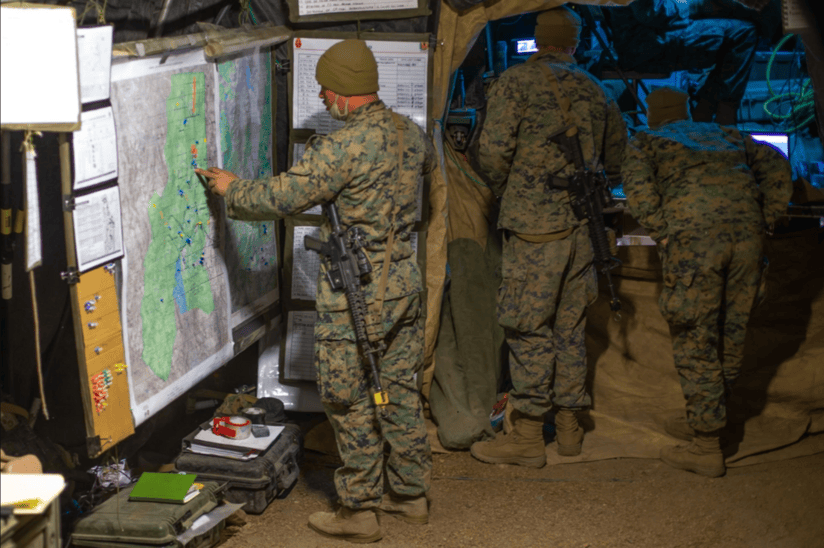
The Combat Operations Center (COC) is the brain of any military operation. It processes reports and data from the troops on the ground and disseminates orders and tasks from the commander. When entering a COC, the first thing you notice are walls filled with maps and more maps. Each map is covered in layers of acetate that track friendly units, suspected adversary unit locations and their likely actions, fire support plans, and much more. Surrounding the maps are laminated poster boards for tracking position reports, logistics status reports, preplanned targets, significant events, casualty reports, and everything else required to provide the commander with the information needed to make decisions.
In short, it’s a chaotic and highly analog environment.

To those of us working on critical missions, our analog poster boards represent what accurate information should look like. The information posted in the COC is the collaborative result of dozens of subject matter experts: personnel management, intelligence, ground operations, aviation operations, fire support, logistics, and communications. These experts synthesize and curate the information needed by the commander and other staff to make timely and accurate decisions. The COC is the central source of everything happening in as close to real time as we can make it.
When I was picked to be the SharePoint guy, little did I know that I’d learn to turn SharePoint into a digital COC. In the right hands, SharePoint has the capabilities to be just as effective, and more efficient, than the combat operations center posters and maps. It is not glamorous, it is not particularly high tech, and like I said, it is not popular. But I am here to report that SharePoint’s site-building capabilities combined with ArcGIS for SharePoint are the tools you need.
Build your digital COC with ArcGIS for SharePoint
Sometimes, the most effective SharePoint tool is the simplest, and all you need is a map on your SharePoint page.
The right map helps you to overlay and display your data and bring a common understanding to the mission. Visualizing where your forces are located and where significant events are happening are critical to inform your decision-making process.
Following my time as a Marine, I started working for Esri. It did not take long before my love of SharePoint became obvious to others on my team. Earlier this year, Zoya Domashnev from the documentation team for ArcGIS for SharePoint and I decided to collaborate on a blog article focusing on my experience using SharePoint for real-life operations. As we began writing the blog, we found that the COC use case for combining ArcGIS capabilities with SharePoint was too universal to limit it just to the military.
We decided to split the blog into two separate articles: (1) the story you are now reading focusing on how I successfully used ArcGIS for SharePoint to improve operational awareness up, down, and across the chain of command. And (2) an article focused on how to create the SharePoint site and structure the connections with ArcGIS for SharePoint to integrate lists with maps.
To find out what you can do with custom list views, see Zoya Domashnev’s article, Dynamic mapping with SharePoint list views.
Putting Zoya’s workflow to use
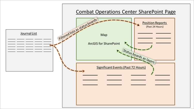
SharePoint is best when it is kept simple. In our COC, the journal was maintained to capture all events that occurred. It held all information, from simple position reports submitted from subordinate units to significant events that unfolded around the battlespace. In the analog COC, those journal entries were then rewritten on the posterboards and hand-plotted on the maps along the walls.
In the digital SharePoint COC, this second step is not required. A custom view for position reports will display only those journal entries labeled POSREP from the Journal primary list. Likewise, a second custom view for significant events will only display journal entries labeled SIGEVENTS. Both these custom lists will be displayed on our COC SharePoint site along with a map from ArcGIS for SharePoint to geographically display just these journal events.

This workflow is recommended to get started with your SharePoint-based COC and ArcGIS for SharePoint. Your operations clerk focuses on entering accurate journal entries while the custom list views automatically update. You still meticulously maintain your analog posterboards and maps around the physical COC, but your digital COC continuously remains updated with no extra users required. It keeps the staff aware of what is always happening from their dedicated workstations while keeping extra people out of the physical COC – an operations chief’s dream.
Be the information hub
By adding an ArcGIS for SharePoint map on your site, your digital COC is ready for action. Not only do relevant people collocated with the COC have a complete picture of what is going on, but so do stakeholders around the globe (if they have the correct permissions). Headquarters can follow along with your mission clearly and quickly on the dynamic map. Adjacent units can see significant events that may soon enter their battlespace on the corresponding list view. Subordinate units can see how they fit into the larger picture by selecting information on a list and seeing it highlighted on the map. With ArcGIS for SharePoint and filtered list views, your organization’s site will be unstoppable.

Learn more
To explore more about what you can do in ArcGIS for SharePoint, check out the ArcGIS for Microsoft 365 resources page, the ArcGIS for SharePoint documentation, or the ArcGIS for SharePoint Esri Community site.

Article Discussion: