ArcGIS Field Maps is a mobile app solution that allows you to streamline field workflows and take maps anywhere. You can use Field Maps to explore the maps you make in ArcGIS, collect and update your authoritative data, and record where you’ve gone, all within a single location-aware app. Field Maps includes a companion web app that allows you to configure the maps mobile workers use in the field.
Released in October 2020, last updated in April of 2021, we’ve opened our early adopter program to provide early access to our summer release. As a member of the early adopter program, you’ll gain access to development builds of the Field Maps web, iOS and Android apps that you can use directly with your ArcGIS Online subscription!
Early access capabilities
There are lots of exciting new features coming in ArcGIS Field Maps and here are just a few of the new updates that you can look forward to testing.
Sharing maps
Within the Field Maps web app, you’ll find a great new experience for sharing the maps you’ve configured:
- First, you’ll see how the map is currently being shared. By clicking the Set sharing level button, you can use the standard share dialog that you are familiar with to share your map and any dependent layers to the groups your mobile workers use.
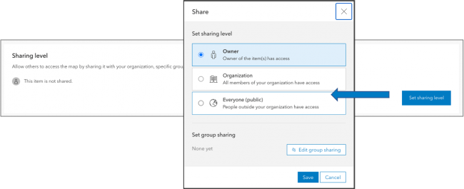
- After you’ve set the sharing level, Field Maps generates a unique, shortened URL that you can copy to the clipboard and paste into an email or text message that you prepare for your mobile workers. A QR code is also generated and can be scanned directly from the camera on your device. When mobile workers tap the link or scan the QR code on a mobile device, the map is opened in Field Maps. It’s never been this easy to deploy maps!!
- We moved the Hide in Field Maps mobile switch from the Overview page to the new Sharing page as well. Sharing is often the last step in the configuration process and the most natural place for you to provide access to maps.

Data Collection and Editing
ArcGIS Field Maps provides a number of different methods for capturing and editing the location of a GIS feature. The most common method is to tap Add  and either use GPS or the map to capture location. However, you can also select a feature, search for a location, or drop a pin and tap “Collect Here” and use that location to start your collection as well.
With this update, we are dramatically enhancing the Copy feature action so that you can copy the location of a feature, the location and attributes of a feature, or just the attributes of a feature (as supported in the current release).
You can control the behavior of the Copy feature action using the Field Maps web app for each map as well.

The Copy capability is extremely powerful, promotes efficiency in data capture, and supports all of the functionality of Collector Classic and more.
Delete All Points
We’ve added a new collection setting to the Field Maps web app that extends the collection menu so that you can delete all points within a line or area shape.

Shared Update Groups
Quite often multiple map authors need to collaborate when building and configuring maps. Shared update groups were introduced to support this effort but until now, the ArcGIS Field Maps web app required that the signed in user own the map. With support for shared update groups, now multiple map authors can configure the same map.
Smart Forms
With the initial release of Field Maps, we introduced smart forms. The new form capabilities are stored inside of your maps and their advanced editing logic is available within Map Viewer as well as within the Field Maps mobile app. An effort across ArcGIS, we continue to grow and evolve their capabilities.
Switch Input Type
Yes/No type questions are quite common on forms and in this update we are introducing a new Switch input type that you can choose from when formatting fields. Please note that your field needs to have a list with only 2 choices and a default value set.

Conditional Visibility
We’ve made some quality of life improvements to the Field Maps web app in this update.
Conditional Visibility expressions can be re-used within the same form. You no longer need to copy the expression if it needs to be applied to multiple attributes or groups.

You can see which groups and attributes are using an expression:

Expressions can also be duplicated, edited, or deleted.

Utility Networks
Starting with the iOS platform, we are adding support for the Utility Network. Important to our development is that we expose the sophistication of the Utility Network but maintain simplicity and ease of use within ArcGIS Field Maps.
Network tracing
Within ArcGIS Pro, you can configure a trace and provide network tracing capabilities to your mobile workforce using a named trace configuration. Named Trace Configurations contain all the parameters of a trace and hide the complexity from the mobile worker. Each map can have a set of named trace configurations shared with it and any named trace configuration shared will show up when that map is used in Field Maps when a network element is selected.

The above map includes both an Upstream and Downstream named trace configuration that is included with the electrical distribution network you see in the map.
Tapping on a trace configuration, you are presented with required parameters. The trace is executed and the results are selected on the map and inside of the panel. Network functions that may have been included in the configuration are provided as well.

In the example above, after selecting a transformer and tapping on the Downstream trace configuration, the mobile worker can choose to trace the high or low voltage wire depending on their workflow need. The downstream results are selected on the map and in the panel.
Showing Connectivity and Structural Attachment Associations
Field Maps is the ideal mobile app for viewing a utility network. Distribution networks include a lot of map layers, and grouping layers together so that you can work with them effectively on a mobile device is critical. When a map includes a utility network, Field Maps becomes aware of the network and you can discover additional ways to visualize the content within your network. Opening the Layers tool, you will see a section titled NETWORK LAYERS where you can turn on/off visualization of network connections and attachments.

In this example, we can visualize the structural connections between the high voltage transformer bank, switches and terminals inside of a substation.
Containment
Containment is an association relationship in the Utility Network. When you select a feature which acts as a container in the Utility Network, the View Contents feature action will be visible in the panel which appears when a feature is selected and will provide the number of contained elements. Tapping on the feature action, you can drill down and select each individual element and access its details.

In the above example, tapping on a substation allows you to view the contained network elements inside.
What’s Next
As you can see from the list above, there are a lot of great additions to Field Maps coming and we really want you to take these capabilities for a spin in the early access program. Here is the link where you can join over 6,000 early adopters and get access to development builds to test.


Article Discussion: