A few weeks back I blogged about the types of data joins you can do in Insights for ArcGIS. Now let’s look at how you can find spatial trends through simple drag and drop steps using spatial joins, location enablement and spatial aggregation.
Let’s start by looking at online shopping trends.
While this analysis shows retail activity, these features may apply to just about anything you can imagine.
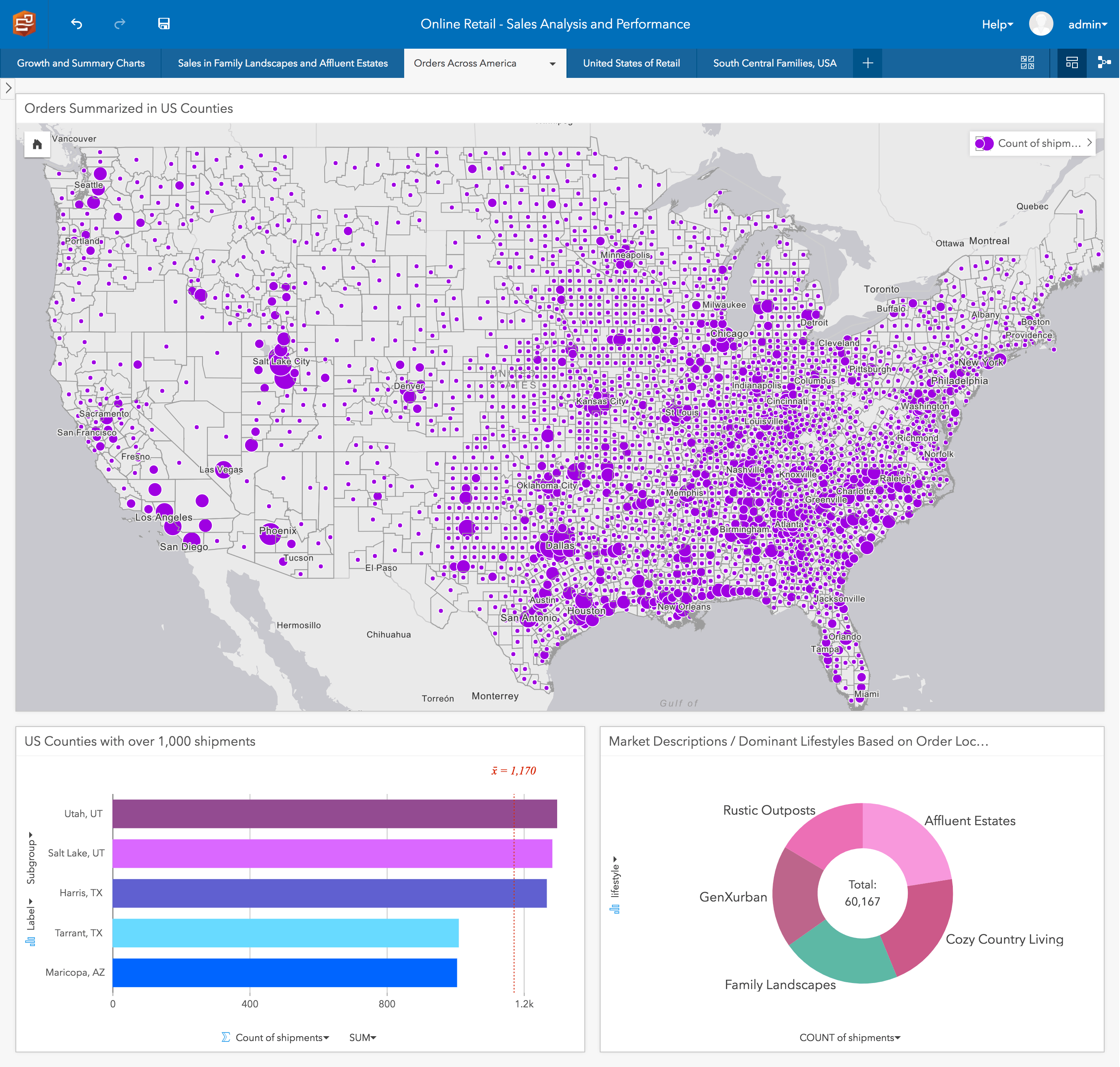
Take a moment to look at the distribution and amount of sales across America (above purple map with rings showing quantities). Look around the South and South / Central areas of the United States. Clearly something is going on in this area!
Another trend appears to be who may be buying this online product. Through simple spatial aggregation, I can tell that orders are less common in major metropolitan areas and more common in family landscapes near mid-sized cities. So maybe it’s time to hit pause on that pricy advertising project in New York City?
Now let’s dissect.
Geo-Enablement
Oftentimes data sets will include location information, but lack a geometric dimension essential for spatial analysis. Insights handles this in a variety of ways through built-in Geo-Enablement capabilities. For any data set, Insights can transform a description of a place — such as a pair of coordinates, an address, or a name of a place — to easily create mappable locations for spatial analysis. This is perfect when the starting point may be an address, zip code or city name.
For this example, I enabled location by choosing the customer address included in my orders table. Alternatively, if my data has coordinates I can use these values or I can relate my data to a spatial layer by common field, such as how classic joining works.
Spatial Join
What about when there is no common field to join on? In my last blog, I talked about how to join many tables together using common fields. Now I am going to say there is another approach, you can join based on location! A spatial join is powerful. With Insights, you can join points, lines and polygons together. If your data shares a geographic relationship with other spatial content, Insights can perform a spatial join to merge data sets. This means you can join information from well-known standard geographies to custom things like roads, railways, buildings or neighborhoods.
In this example, I joined order locations to census blocks which are one of many curated spatial data sets included within Insights.
The reason I choose to use spatial join was to unite categorical and demographic information into my orders, which are maintained at the census block level. After doing this, interesting discoveries can be made about the communities buying this product.
Spatial Aggregation
Spatial aggregation helps you understand quantities of commodities in geographic areas. The process of summarizing data into counts and amounts from one geographic feature into another is spatial aggregation. This is perhaps my favorite Insights feature. Here’s why. The experience for doing aggregations makes you feel like a Miami vice crime scene investigator, even when you may just be crunching retail numbers. It’s simply drag and drop!
In the map above, I aggregated the number of customer orders within each county using spatial aggregation. Instead of showing the total number of orders, I could have shown average sale amount or total sale amount within each county. Additionally, I could have symbolized my map using a variety of different colors and styles.
Conclusion
Hopefully this blog has inspired you to think about the hidden spatial trends that may be in your data. Together Spatial Join, Location Enablement, and Spatial Aggregation can create powerful and profound analytics for retail and/or any discipline you can imagine. So give it a try! Please check back for more ways to make your data actionable and ready for analysis.
Want to read more? Visit our documentation.
Give “Spatial Join, Location Enablement and Spatial Aggregation” a try with your data? Don’t have access to Insights for ArcGIS, follow this link to get a free trial!

Commenting is not enabled for this article.