Product teams at Esri are excited to meet you at the 2025 Developer & Technology Summit in Palm Springs between March 11 and March 14! Join us for a variety of technical sessions, live demos, case studies, and more. Dive into our extensive resources and get answers to all your questions from the engineers behind ArcGIS Maps SDK for JavaScript, Calcite Design System, and the rest of Esri Developer technology. This guide will help you make the most of your time at the conference.

Key Sessions to Sharpen Your Web Development Skills
The following curated list of sessions covers some of the key technical presentations specifically designed for web developers who are looking to enhance their skills in web mapping and development. These sessions are categorized by capabilities, enabling you to focus and deepen your knowledge across specific topics.
Build Applications with Web Components – A 3-Part Series
With Esri’s focus on building standards-based web components that extend the core API of ArcGIS Maps SDK for JavaScript into reusable custom HTML elements, we strongly recommend developers to use components for building web applications. We are offering a three-part presentation series covering the core aspects of building web applications using JavaScript Maps SDK components.
App Development with Components Part 1: Core Patterns
This session, the first in a 3-part series, introduces core concepts and programming patterns for maximizing development productivity with ArcGIS Maps SDK for JavaScript web components. Topics include map (map, scene, and legacy widget equivalents), chart, and coding components.
Tuesday, Mar 11 | 02:30 pm – 03:30 pm PDT
App Development with Components Part 2: Using Frameworks
In this second session, explore motivations for using front-end frameworks and techniques for integrating web components with React and Vite. Topics include dependency management, asset management, semantic versioning, and the benefits of frameworks for streamlining web mapping development.
Wednesday, Mar 12 | 01:00 pm – 02:00 pm PDT
App Development with Components Part 3: User Experience
This third session focuses on creating intuitive and powerful user experiences in your web app using components and the Calcite Design System, which offers patterns, icons, and configurable web components for responsive, accessible apps.
Thursday, Mar 13 | 01:00 pm – 02:00 pm PDT
Mapping and Visualization
Effective visualization turns web maps into captivating and informative stories. Join our sessions to expand your knowledge of 2D and 3D visualization, learn techniques for meaningful visualizations of dense datasets, and enhance your web mapping apps with custom styles and animations.

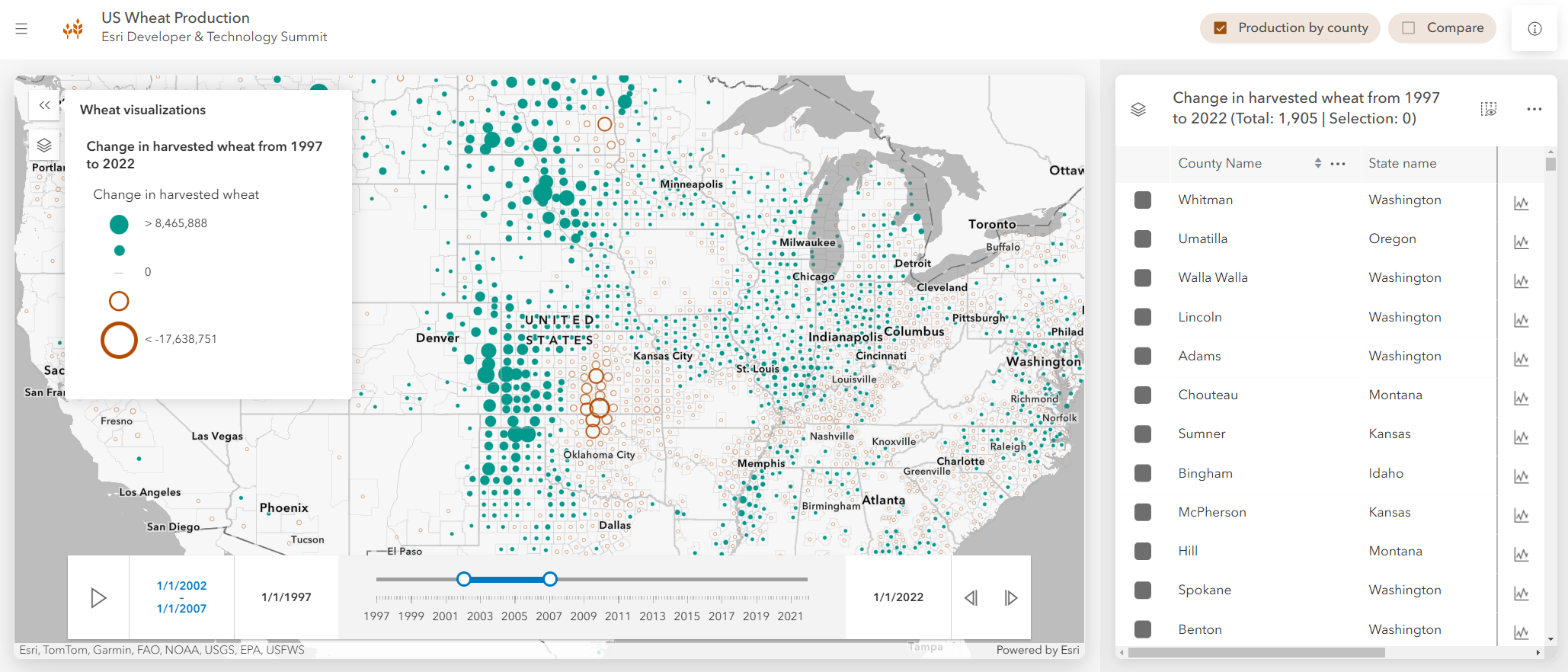
ArcGIS Maps SDK for JavaScript: 2D Visualization Techniques
This session covers visualization techniques for vector data in the API. Learn how to transform raw data into compelling stories with data-driven visualizations and gain confidence in making smart visualization choices.
Wednesday, Mar 12 | 11:00 AM – 12:00 PM PDT
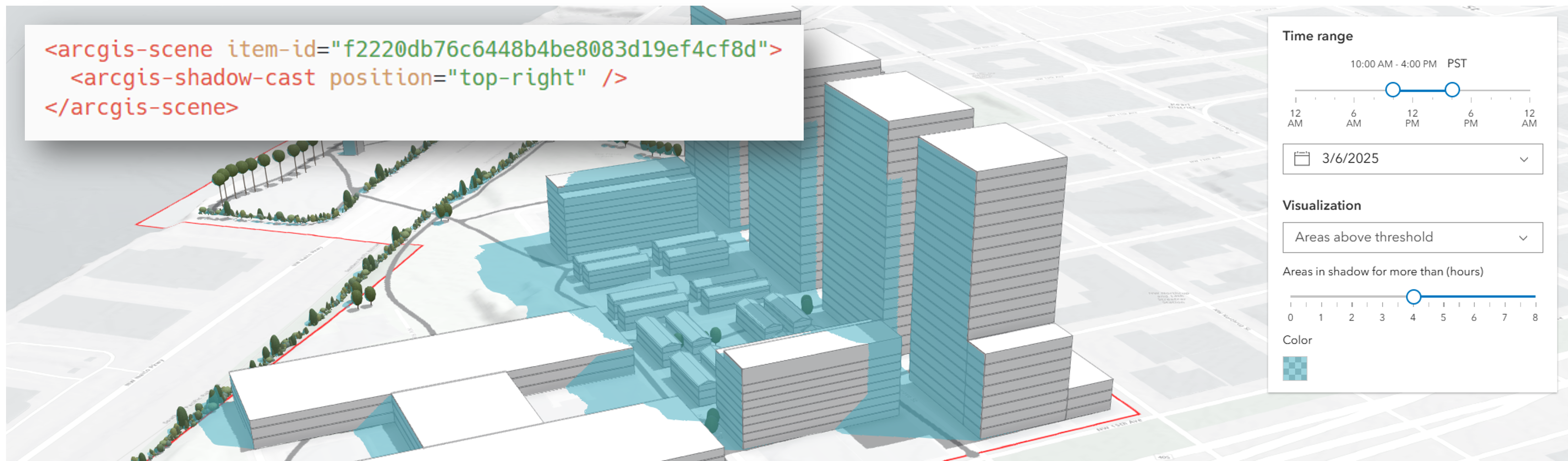
ArcGIS Maps SDK for JavaScript: 3D Visualization Techniques
This session focuses on the 3D visualization capabilities of the ArcGIS Maps SDK for JavaScript. Learn about symbol types, visual variables, and unique 3D cartographic techniques. See demos of thematically visualizing 2D features with 3D symbols and get an overview of 3D-specific data layers, including I3S scenes, integrated meshes, and building scenes.
Wednesday, Mar 12 | 1:00 PM – 2:00 PM PDT
Build Compelling User Experiences
Esri’s web development offerings enable the seamless creation of interactive and intuitive web experiences. Calcite Design System, and JavaScript Maps SDK’s extensive library of pre-built experiences encapsulated as components provide the necessary resources to develop engaging web applications.
App Development with Components Part 3: User Experience
This session focuses on creating intuitive and powerful user experiences with user experiences with components and the Calcite Design System, which offers patterns, icons, and configurable web components for responsive, accessible apps.
Thursday, Mar 13 | 1:00 PM – 2:00 PM PDT
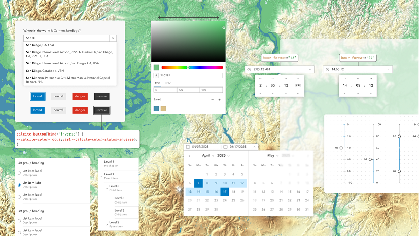
Building Accessible Web Apps with ArcGIS Maps SDK for JavaScript and Calcite
Learn to make your app accessible using the ArcGIS Maps SDK for JavaScript and the Calcite Design System. Discover new accessibility features in Maps SDK and Calcite and follow WCAG standards and best practices. We’ll demonstrate a sample application that incorporates these accessibility best practices.
Wednesday, Mar 12 | 1:00 PM – 2:00 PM PDT
ArcGIS Maps SDK for JavaScript: Better UX with Popups
In this session, you’ll learn to utilize new features in the Map Viewer and ArcGIS Maps SDK for JavaScript to customize the popup’s appearance and behavior. We’ll cover configuring elements, working with Arcade, and displaying charts to meet your application’s requirements.
Tuesday, Mar 11 | 5:30 PM – 6:30 PM PDT
ArcGIS Maps SDK for JavaScript: Tabular Data Exploration in Feature Table
The Feature Table component offers an interactive tabular view of feature attributes. Recently overhauled, it now includes new customization options and the ability to configure and save settings in the web map. In this session, we’ll demonstrate workflows for tabular data exploration, embedding custom functionality, and enabling map interactivity.
Thursday, Mar 13 | 5:30 PM – 6:30 PM PDT
ArcGIS Maps SDK for JavaScript: Client-Side Queries & Analysis
This session will cover advanced client-side visualization and analytical techniques, including queries, filters, effects, charts, tables, and the new geometry engine. These operations are performed directly in the browser, reducing latency.
Thursday, Mar 13 | 1:00 PM – 2:00 PM PDT
Working with Layers and Data
Data is the backbone of the ‘science of where.’ Esri’s web development offerings enable developers to create insightful analyses and build powerful workflows with data, whether it is already hosted within the ArcGIS ecosystem, available in an open format external to ArcGIS, or ready to be captured.

ArcGIS Maps SDK for JavaScript: Tabular Data Exploration in Feature Table
The Feature Table component offers an interactive tabular view of feature attributes in a layer. Recently overhauled, it now includes enhanced customization, configuration persistence in web maps, and improved interactivity with the map. This session will demonstrate workflows for tabular data exploration, embedding custom functionality, and enabling map interactivity.
Thursday, Mar 13 | 5:30 PM – 6:30 PM PDT
ArcGIS Maps SDK for JavaScript: Max Speed & Capabilities of the Feature Layer
The Feature Layer is ideal for working with feature data directly on the web. This session explores various options and techniques to optimize its performance in your web application, including service configuration, caching, and client-side queries to leverage data already in the web browser.
Tuesday, Mar 11 | 5:30 PM – 6:30 PM PDT
ArcGIS Maps SDK for JavaScript: The Secrets Behind 10 Inspiring Web Apps
In this session, presenters will showcase apps developed with the ArcGIS Maps SDK for JavaScript, revealing techniques for engaging experiences. They’ll explore a diverse range of 2D and 3D use-cases to inspire improvements to your existing web apps and provide ideas for future solutions.
Thursday, Mar 13 | 2:30 PM – 3:30 PM PDT
What’s New and What’s Coming?
The Web Development team is dedicated to delivering the latest features and enhancements. Learn about the latest advancements from the three 2024 releases and preview what’s on the horizon for 2025.

ArcGIS Maps SDK for JavaScript: What’s New
Attend this session to explore the most significant advancements in the ArcGIS Maps SDK for JavaScript from 2024. Get inspired with new ideas for your web apps and gain insights into what other sessions will cover, helping you plan your DevSummit week effectively.
Tuesday, Mar 11 | 4:00 PM – 5:00 PM PDT
ArcGIS Maps SDK for JavaScript: Road Ahead
In this session, product managers and development leads will delve into the road map and development strategy for the ArcGIS Maps SDK for JavaScript in 2025.
Thursday, Mar 13 | 2:30 PM – 3:30 PM PDT
Esri showcase schedule
| Day and Date | Time | Location |
| Tuesday, March 11, 2025 | 1:00 p.m.– 6:30 p.m | Expo | Oasis 1–2 |
| Wednesday, March 12, 2025 | 10:30 a.m.– 6:30 p.m | Expo | Oasis 1–2 |
| Thursday, March 13, 2025 | 10:00 a.m.– 4:00 p.m | Expo | Oasis 1–2 |
📍 Locate the Web Development team in the Expo Hall!

We’re thrilled to meet you at the Palm Springs Convention Center! If you haven’t registered for the 2025 Esri Developer and Technology Summit yet, don’t wait—Register Now!
To explore more about the ArcGIS Maps SDK for JavaScript, visit our webpage. For detailed documentation, head over to the Esri Developer site. Also, stay in the loop with the latest in Developer technology by subscribing to the Esri Developer Newsletter.


Commenting is not enabled for this article.