Updated December 15, 2016: The Esri Vector Basemaps are no longer in beta release and are now available to use in production web maps and apps. The best way to access them in ArcGIS Online is through the Esri owned Vector Basemaps group, which contains the latest set of web maps and tile layers. See this blog post for information related to this update.
—
The Esri vector tile basemaps (beta) were recently updated with newer data content and improved map styles. There are now nine different basemap styles available for use in ArcGIS Online to build maps and apps. This is a continuation of our Beta2 (B2) tile release that we blogged about in May 2016. During this beta period we continue to update the underlying data used to create the vector tile set. Our release this week was the third update of the tile set used on ArcGIS.com since the release of B2 tiles in May. We’ve added or updated over 50 community-contributed areas since May, in addition to countless other updates from commercial and open data sources. We are well into the next round of tile creation and data updates. We will increase the frequency of releases for the vector tile basemap updates.
Why vector tile basemaps?
Four reasons in favor of using the Esri Vector Tile Basemaps:
1) Updated data. Because the amount of time required to produce our vector basemap tile set is greatly reduced compared to raster caching, we are able to make more frequent tile updates. With each update, we publish the latest set of our data. We collect and process data from commercial sources, open sources, and our community contributions made to the Living Atlas of the World. Even during the beta period, we are able to release data from these sources in a shorter turn-around time than to our raster basemaps. Each vector basemap style points to the same single vector tile set. Compare that to rasters where each map style produces its own set of cache.

2) Community Data. Many of the feature classes contributed through the community map program appear in all the basemap styles each time updated tiles are published. This is because all the different vector basemap styles point to a single set of vector tiles. They are stylized by separate resource files (per style) stored on ArcGIS Online. In the raster maps, each style has to be cached separately.
3) Customization. The vector tile basemaps allow you to customize the map style and content of your maps. You can change colors, fonts, line widths, etc. in your own map style. You can also turn off layers of features you don’t want to show on the map. There are currently a couple of apps available to assist you in this venture, or you can download the map style file (root.json) and directly edit the code. See below for info on these apps.
4) Hi-Res. Vector tile basemaps display better on today’s high resolution devices than their raster counterparts.
What does this latest update mean to my vector tile basemap use?
If you are using a tile layer or web map that uses the Beta2 (or B2) set of tiles without any customization, the latest updates will automatically be reflected in your maps (you may need to clear your browser cache).
If you’ve made customization to the root.json style file, the vector tiles your styles are pointing to will automatically contain the latest data updates, but your map style will not reflect the latest code changes we applied. Some customization may need to be re-applied in the new root.json now associated with this set of new B2 tiles. See recent blog posts How to Customize Esri Vector Basemaps and Customize Esri Vector Basemap Boundaries and Labels for more detail. The Esri Vector Basemaps Reference Document is also a good source for information about current map layers, min and max zoom levels, content, fonts, and more.
Where do I find these Esri Vector Tile Basemaps?
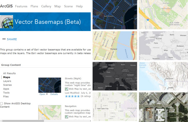
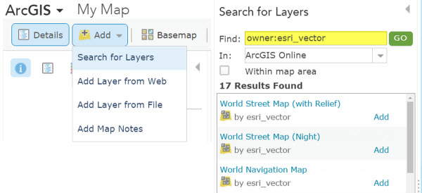
There are two main ways to find the vector tile basemaps in ArcGIS Online, both tile layers and web maps. The first is in this public group: Esri Vector Basemaps (Beta). Bookmark it! This set of 9 tile layers and 9 web maps are the most up-to-date set of our basemaps. They are items owned by “esri_vector”. That leads to the second way to find them. In the map on ArcGIS.com, when you add data, search for layers using the syntax “owner:esri_vector”. This pulls all the vector tile layer styles that are also in the group detailed above.
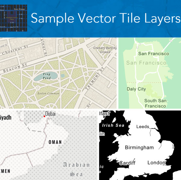
In addition to the set of nine Esri Vector Basemaps (Beta) group, we also have a growing group of customized styles. This other group is our Sample Vector Tile Layers group. These offer ideas on the different levels of customization you can do to your own maps. These sample layers can also be used in your maps and apps. This sample set offers maps with basic color changes like the seasonal themed maps to full-on redesign and complex style changes like those seen in the Modern Antique sample web map. More tools will be released during our beta period allowing you to upload custom changes to add fonts, patterns and symbols (sprites) stored in the resource directories.
How can I customize the vector tile basemaps?
There are a few ways to make your mark on your own style of vector tile maps. To customize one of the Esri Vector Tile Basemaps, you’ll need to make a copy of a vector tile layer and save it to your ArcGIS.com account. Step-by-step details how to copy and save a tile layer that you own are available in the Esri Vector Basemaps Reference Document or this previously published blog.
There are currently two apps (also in beta) created by Esri that are available to style your maps. These apps offer a more user-friendly UI than just editing json code without being able to actively see the impact of your changes. Both apps require a log-in to your ArcGIS Online account. The apps display the tile layers available to edit from your content. It is strongly recommended in both apps that you make a copy of any tile layers before you start to customize them.
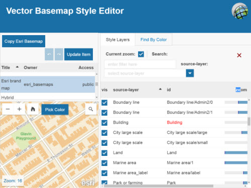
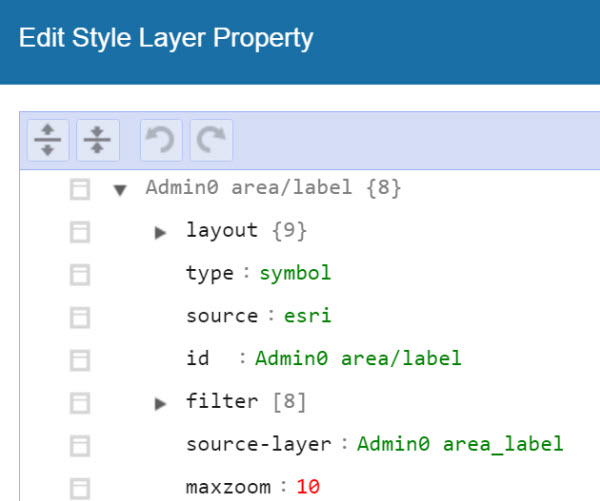
Vector Basemap Style Editor (beta) is a styling app that allows you to quickly and easily turn on and off feature layers, find features by colors, apply bulk color changes for all features with that specific color, and more. Click on the ‘id’ name of a layer and more detailed, json-based edits can be made. Updating the item from the app saves the new style changes in your online account.
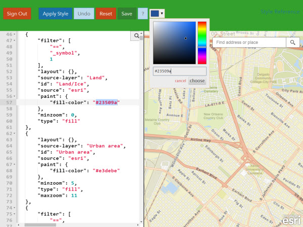
Vector Style JSON Editor (beta) is another styling app that exposes the json code in one half of the window, and the map in the other half. The app offers a color picker and the ability to search and find features to change by layer names or hex colors. Applying changes to the code shows immediate results on the right side of the window. Saving the style changes updates that tile layer in your online account.
Watch this space for additional blogs detailing the latest information about the Esri Vector Tile Basemaps.

Article Discussion: