In an effort to revitalize a historically underserved area, the St. Louis Development Corporation (SLDC) commissioned a project focused on the Dr. Martin Luther King Drive corridor, a priority for development in the city’s Economic Justice Action Plan.
To bring this vision to life, the SLDC engaged with Esri Gold Partner Houseal Lavigne, an urban planning and geospatial design firm. Houseal Lavigne used ArcGIS Maps SDK for Unreal Engine to import real-world GIS data into an Unreal Engine application. They were able to create a lifelike, interactive city model that can be explored as if in a video game. This virtual “digital twin” aims to support the revitalization efforts in the area.
This immersive experience proved essential for demonstrating potential urban transformations in a manner that was both tangible and accessible to all residents, irrespective of their technical skills. By merging the geospatial accuracy of ArcGIS with the visual excellence, high-performance rendering, special effects, and animation capabilities of Unreal Engine, the project team was able to deliver a compelling and realistic experience.
As a result, the digital twin has been crucial in community engagement efforts, allowing residents to visualize potential and improvements in their neighborhoods, thus fostering a sense of ownership and inclusion. The success of this project in enhancing urban planning and decision-making processes has set the stage for further expansion of digital twin technology across the city, aiming to improve infrastructure, transportation, emergency management, and overall urban and economic growth.
Addressing Urban Disparity and Enhancing Community Engagement in St. Louis
St. Louis, Missouri, a city in the American Midwest with nearly 300,000 people, has a history marked by segregation and economic disparity, creating a cityscape where neighborhoods just blocks apart can have vastly different social and economic conditions. This division goes beyond just property values; it significantly affects residents’ quality of life, access to essential services, and opportunities for economic advancement. The roots of these disparities lie in historical policies like redlining and racially restrictive covenants, which have had a lasting impact on the city’s geographical and social structure, perpetuating a cycle of poverty and disinvestment in certain areas.

The city has faced significant challenges in engaging the community in urban development processes. Traditional methods of outreach and planning have often failed to capture the attention or earn the trust of the residents most affected by proposed changes. This has led to skepticism and a disconnect between the city’s plans and community’s actual necessity, making it difficult to implement projects that truly benefit the most vulnerable populations. There is a clear need for more effective engagement strategies that resonate with and include these communities in meaningful ways.

Recognizing these issues, St. Louis has acknowledged the necessity for a new approach to urban development that addresses the physical aspects of development and fosters a sense of ownership and inclusion among all residents. This new strategy involves leveraging innovative tools to visualize the impact of development projects and ensure that growth and investment benefits are equitably distributed across the city. By transforming the way the city plans and interacts with its residents, St. Louis aims to use technology to bridge the gap between current realities and future possibilities, creating a more inclusive and equitable urban environment.
Revolutionizing Urban Planning in St. Louis with ArcGIS Maps SDK for Unreal Engine
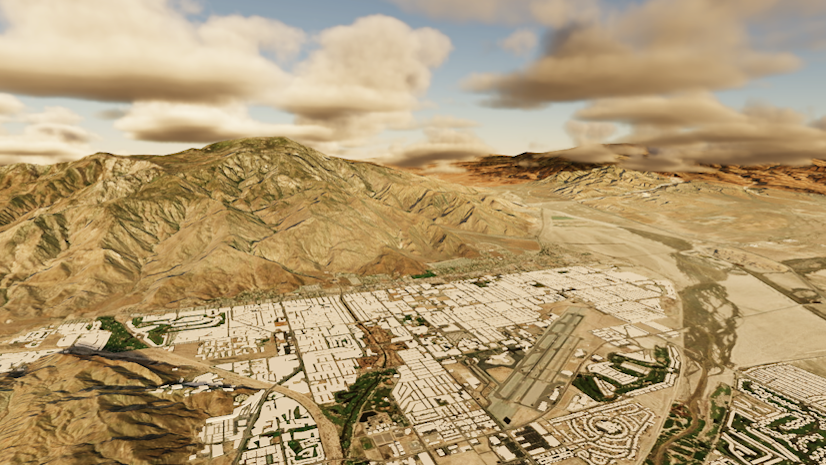
To address the deep-seated issues of economic disparity and community disengagement, the St. Louis Development Corporation (SLDC) and Houseal Lavigne adopted a groundbreaking approach by integrating ArcGIS Maps SDK for Unreal Engine into their urban planning and community engagement processes. The primary deliverable for the project was a production-quality video showcasing the dynamic transformation of St. Louis neighborhoods, particularly focusing on historically underserved areas. The video vividly depicted renovated structures, new buildings, and businesses rising from the ground to demonstrate renewal. Additionally, the solution provided an interactive experience for city leaders and community members, fostering involvement and supporting informed decision-making. This digital twin of the city is not just a technological achievement but a new way to engage the community and drive positive change.
The data collection and provision for the St. Louis digital twin project, managed by Houseal Lavigne, was a comprehensive initiative that involved multiple city departments under the coordination of the SLDC. Leveraging the city’s extensive GIS databases, the project team gathered crucial data layers. “We modeled using the data from the city, so building polygons, parcels, road center lines, street furniture and a bunch of other things,” noted Devin Lavigne highlighting the depth of data integration. This rich collection of GIS data was pivotal for creating a realistic and interactive 3D model of St. Louis, enabling Houseal Lavigne to accurately replicate the physical characteristics of the city’s neighborhoods.

Furthermore, the project did not just rely on current GIS data but also incorporated historical data to provide a temporal dimension, showcasing the city’s development over time and aiding in understanding the long-term impacts of urban policies. Contributions from local businesses, community organizations, and residents added additional layers of data, which enriched the digital twin model to reflect the lived experiences and realities of St. Louis’s diverse population. To ensure the digital twin remained accurate and relevant, St. Louis established protocols for ongoing data updates and management, adapting the model to reflect new developments and changes within the city. This dynamic approach not only facilitated the visualization of potential urban developments but also enhanced decision-making processes, providing a scalable and detailed model of the city’s future.

The idea was to show the vision, before and after, of what the neighborhood could look like
Transforming St. Louis: Digital Twin Technology and Its Impact on Urban Revitalization
The digital twin technology implemented in St. Louis and spearheaded by the SLDC and Houseal Lavigne, marks a significant transformation in urban planning and community engagement. This project, integral to the Economic Justice Action Plan, focused on revitalizing historically underinvested areas, addressing issues such as crime and poverty. By creating a dynamic 3D visualization of potential urban developments, the digital twin allowed stakeholders to visualize and engage with future changes, playing a crucial role in the mayor’s state of the city speech and supporting economic revitalization efforts along key areas like Martin Luther King Boulevard.
Moreover, the digital twin was instrumental in enhancing decision-making processes. It enabled city planners and developers to simulate various development scenarios, assessing potential impacts before any physical changes were made. This proactive approach minimized risks and optimized planning, setting a precedent for other cities dealing with similar challenges of economic disparity and community disengagement. The project not only demonstrated the power of technology in urban development but also emphasized the importance of collaboration and good data in crafting inclusive, transparent, and effective strategies for sustainable growth.
What’s Next
The successful implementation of the Dr. Martin Luther King Drive corridor project has paved the way for broader adoption of digital twin technology throughout St. Louis, powered by the ArcGIS Maps SDK for Unreal Engine. The city plans to extend this technology to additional neighborhoods and sectors, enhancing simulations for infrastructure, transportation, and emergency management, which will increase community involvement. Efforts to make the digital twin platform more user-friendly will include educational programs for residents and the integration of real-time data, improving transparency and interaction. By fostering a more connected and informed community, St. Louis aims to bridge urban divides and create a more resilient and inclusive city for all residents.

For detailed documentation, head over to the Esri Developer Site. Also, stay in the loop with the latest in Developer technology by subscribing to the Esri Developer Newsletter.


Article Discussion: