Groundwater simulation models are mathematical models that help us understand and predict how water behaves in subsurface aquifers. Groundwater models, such as MODFLOW, are commonly used in the industry to predict different aspects of groundwater management including water availability, effects of pumping, contaminant transport, and more.
One of the challenges facing organizations is the communication of information regarding groundwater systems from professional modelers to others within the organization or to the public. Usually, visualization of groundwater models is achieved with specialized software packages. The model input and output files are a set of text or binary files that are difficult to interpret and map without specialized tools.
The workflow presented enables organizations to quickly create maps and GIS layers of MODFLOW models and to publish those on ArcGIS Online. By posting on ArcGIS Online you can share MODFLOW inputs and outputs with anyone within your organization, or share the model results with the public.
Step 1 – Use MODFLOW Analyst tools to import your model into a geodatabase and create maps of your model inputs and outputs
MODFLOW Analyst tools were used to import a MODFLOW model of the Cache valley in northern Utah into a geodatabase. After importing the model a set of map layers were prepared representing model inputs and outputs such as simulated heads, recharge, bottom elevation of layers, and starting heads.
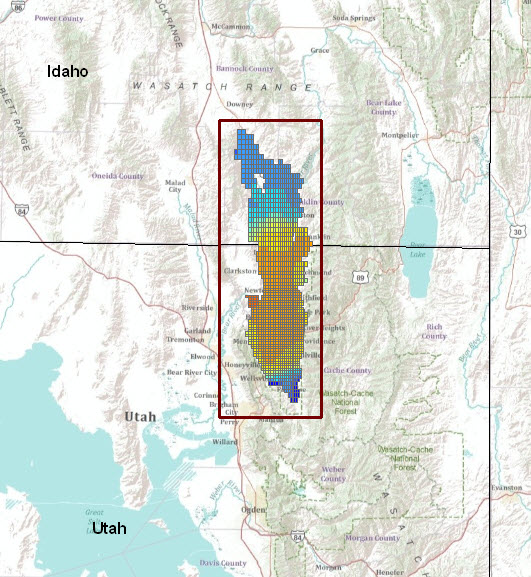
Map of model inputs and outputs from a MODFLOW model of the Cache valley in northern Utah. The model was imported into ArcGIS using the MODFLOW Analyst import tools.
Step 2 – Create map and layer packages and share them on ArcGIS Online
In ArcMap, Map and Layer Packages were prepared. The Map Package enables the whole map content to be packed as a single file and the Layer Package enables exporting a set of selected layers as single file. The exported layers contain the data and layer symbology.
Map and Layer Packages can be automatically uploaded to your account in ArcGIS Online. The process includes entering a description of the map/layers, selecting appropriate tags, and specifying who you want to share the packages with. In this case the packages are shared with everyone.
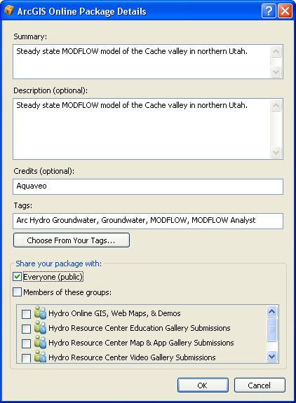
Adding Map and Layer Packages to ArcGIS Online.
Once the packages are uploaded anyone can search for the data on ArcGIS Online and can open the packages in ArcGIS applications (ArcMap, ArcGlobe, ArcScene) or using the free ArcGIS Explorer viewer. The following figure shows the search results when searching for “MODFLOW” in ArcGIS Online.
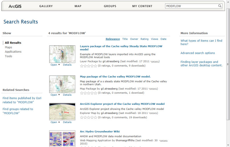
Search results in ArcGIS Online when searching for MODFLOW.
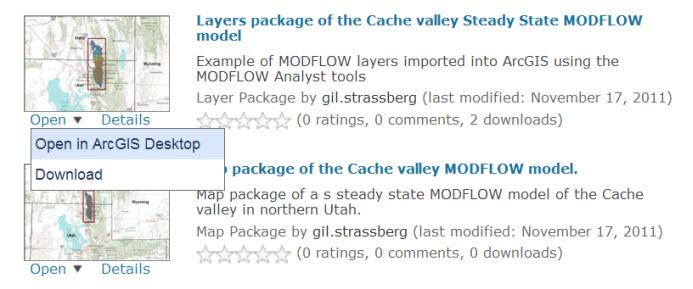
The map and layer packages can be downloaded to your local computer or can be opened directly in ArcMap, ArcScene, and ArcGlobe.
Step 3 – Visualizing in ArcGIS Explorer
One of the interesting options is to open the packaged layers in ArcGIS Explorer. This allows anyone that doesn’t have ArcGIS for Desktop to visualize the results. Using ArcGIS Explorer increases the potential for sharing model information with a large number of users and clients that do not have professional GIS software.
Location of the Cache valley MODFLOW model shown in ArcGIS Explorer.
In addition, ArcGIS Explorer enables you to query the data, change base maps, and add notes and drawings on top of the model data. For example, one can use the Query Builder to display simulated heads for different layers of the model.
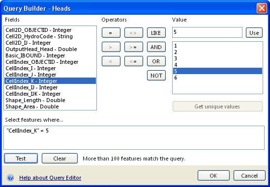
ArcGIS Explorer Query Builder is used to display simulated heads for layer 5 of the MODFLOW model.
The resulting layer from this query is a set of cells displaying only the simulated heads for layer 5. Notice, that the base map has been changed to show the world topographic map with a transparency on top of the world imagery layer. You can be creative and design your own base maps to display your data on.
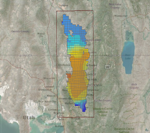
View of simulated heads for layer 5 in the Cache MODFLOW model. The background base map was customized to show the world topographic map with transparency on top of the world imagery layer.
If you are interested in inputs/results at specific locations you can zoom and select individual cells and view their values. The following figure shows the bottom elevation value at a selected cell in layer 5 of the model.
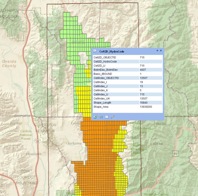
Bottom elevation value at a selected cell in layer 5 of the MODFLOW model.
One of the interesting features of ArcGIS explorer is the ability to create presentations. With this feature you can capture different snapshots of your maps and add text. It is an easy way to communicate your model results. To access the Cache model presentation see the details at the end of the blog.
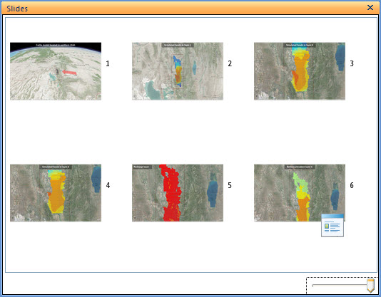
Presentation created in ArcGIS Explorer to show different inputs/outputs of the Cache valley MODFLOW model.
Finally, the ArcGIS Explorer project can be posted on ArcGIS Online. By simply selecting the Share command you have the option to share the map via email or to upload it to your ArcGIS Online account. Once uploaded, the ArcGIS Explorer project can be downloaded and opened by anyone with access to ArcGIS Online.
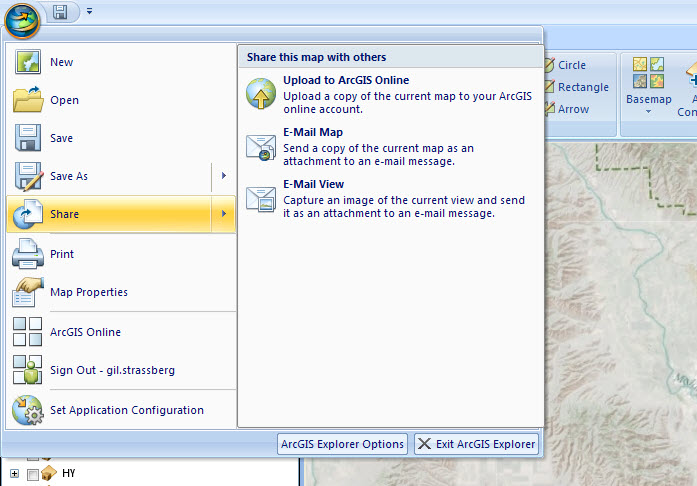
Sharing ArcGIS Explorer maps. You can automatically load the ArcGIS Explorer project t
o ArcGIS Online for sharing.
Summary
The workflow presented is an easy and cost effective way to publish and share information from groundwater simulation models with a wide range of users. Map and Layer Packages can be posted on ArcGIS online and these can be viewed in any of the ArcGIS for Desktop applications. Another option is to view the data in ArcGIS Explorer, so even users and clients that don’t have the professional GIS software can view and explore your models. With ArcGIS Explorer you also have the capability to create presentations that highlight different views of the model.
To view model described in this post you can find the files on ArcGIS Online by searching for “MODFLOW”. Or just follow this link:
http://www.arcgis.com/home/search.html?q=MODFLOW&t=content.
To view the model in ArcMap, just select to open the Map Package or Layer Package using ArcGIS Desktop.
To view the ArcGIS Explorer project:
- Make sure to first download the Layers Package (.lpk file) and the Explorer Project (.nmf file) to the same folder on your desktop and only then open the project.
- You also need to have ArcGIS Explorer build 1750 or later.Thanks to Gil Strassberg for providing this post.
Thanks to Gil Strassberg for providing the post. For more information contact Gil (gstrassberg@aquaveo.com). For more information on the Arc Hydro Groundwater tools visit the Aquaveo website (www.aquaveo.com/archydro-groundwater).
![]()
More information on using ArcGIS Online can be found at: http://www.arcgis.com/home/ and on the dedicated blog: http://blogs.esri.com/Support/blogs/arcgisonline/

Article Discussion: