Two weeks ago, we launched ArcGIS Earth and have had a fantastic reaction from the community. If you haven’t tried it yet, download Earth for free here. With thousands of downloads and many, many positive and constructive comments, it’s been validating to see the nature and volume of your feedback. We’re glad that you find value in Earth and are even having fun exploring this new app.
Your feedback has also helped us identify areas to provide a little more information. This blog will attempt to address some of the common items that we’re being asked about. In future blogs, we’ll address some of the roadmap directions for Earth as well as provide some more practical tips on how to use the 1.0 release.
What is ArcGIS Earth?
Simply put, ArcGIS Earth is an interactive globe viewer that helps you explore any part of the world and work with 3D and 2D map data including KML, shapefiles, and Esri RESTful services. You can display data on the globe, sketch placemarks, measure distances and areas, and add annotations so you can easily understand spatial data.
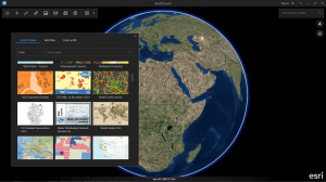
Earth extends the ArcGIS platform by enabling any user in your organization to explore data from Esri and to allow users to access secured data inside an organization. One of the strengths of using Earth and other ArcGIS clients, such as the web scene viewer in the cloud with ArcGIS Online or on-premises with Portal for ArcGIS, is that with these lightweight clients, you can simultaneously consume many data types coming from multiple sources. By designing a new client that takes advantage of the capabilities of the ArcGIS platform, we were able to focus on delivering an experience that will help you distribute access to spatial information and the value of GIS throughout your organizations.
Who is it for?
When we were conceiving ArcGIS Earth, we focused on two key user groups, secure enterprise users and community GIS consumers.
With the gradual withdrawal of Google Earth Enterprise-related on-premises technologies from the market, we heard clearly from many of our customers that they hoped that we would help them fill the capability gap left by the departure of Google. While we know that we won’t close this gap in a 1.0 release and we realize that customers’ needs have changed to also consider web and mobile technologies, we are committed to demonstrating that, for those who need it, we can provide a reliable, installable experience that enables non-GIS professionals to access GIS information in a secure and adaptable tool. (More to come in the future on the configurability of Earth for enterprise users.) Incidentally, our web and mobile capabilities are also part of the overall on-premises enterprise story.
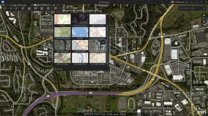
For the wider community of GIS consumers who occasionally want to explore the planet, view shared GIS files, and possibly even have a tool to help communicate using maps, we are providing them with the ability to explore basemaps and 3D terrains in Earth, view shapefiles and KML, and we’re listening to their feedback on our blogs and the GeoNet forum. We encourage educators and researchers to explore the use of ArcGIS Earth in their projects and classes. These users can access publicly shared maps from Esri and the community, such as the datasets in the Living Atlas of the World, a growing collection of curated map data, much of which is accessible without an ArcGIS Online account.
What can I do with Earth at 1.0?
For ArcGIS Earth 1.0, we focused on establishing the user experience for what will become a widely accessible tool for sharing the value of GIS throughout an organization. This means that we focused on:
- Navigating and exploring the globe and map data
- Viewing KML, KMZ, Shapefiles, and ArcGIS services
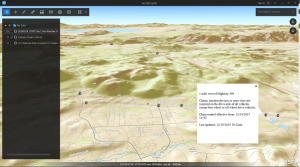
- Basic interaction such as measurement on the globe and popups for KML and shapefiles
- Simple sharing through email and screenshots
We will be expanding the capability of Earth actively, including completing many capabilities that 1.0 and beta users have asked for, such as enabling popups on services and adding more OGC and local file formats. We’ve got a roadmap and we encourage you to keep sending in feedback so we can adjust and expand it.
Some of the following links may be helpful for those who are getting to know Earth or want to provide feedback:
- ArcGIS Earth product home page
- ArcGIS Earth help documentation
- ArcGIS Earth forum on GeoNet
- Introductory presentation on ArcGIS Earth 1.0
What does ‘free’ mean?
ArcGIS Earth is available for download for free on the Esri website from the help pages and from the home page. We do not anticipate and have no current plans to charge for use of ArcGIS Earth with local file information or publicly shared data, either through ArcGIS Online or through an organization’s Portal for ArcGIS Server. We likely will see some users who want to access data that is private to an organization, which will require an ArcGIS account, and in the future we also may explore adding access to credit consuming services, such as the Esri world geocoding service, which also would require an account. Whether inside or outside a firewall, if you are using Earth to browse publicly shared basemaps, services, and local file information, use of Earth is free.

Is Esri really embracing KML?
Esri has been working with KML for years. ArcGIS Earth makes use of, and has helped improve, Esri’s KML engine that is used in other products such as ArcGIS Explorer. Our engine currently offers substantial compliance with OGC KML 2.2 and we are planning additional features such as timesliders and map tours. KML support actually implies many behaviors and experiences of working with data that go well beyond the XML spec. ArcGIS Earth is intended to be a first-class consumer of KML, offering a familiar experience for exploring and presenting with KML data. We intend to continue developing our support for KML, ungeoreferenced COLLADA files, and additional OGC and other open data types as we grow.
Does Esri really think we can replace our Google Earth workflow with ArcGIS Earth 1.0?
Google Earth Enterprise was successfully embraced by many different types of spatial data users for over a decade and remains in wide use. We certainly never thought that we could replace Google Earth Enterprise with the first release of ArcGIS Earth. We are focusing on enabling customers who require certain essential mapping capabilities throughout their enterprise in an easy-to-use package and who can work with us to help develop and mature our roadmap as we move forward. Now that we have put the boat in the water and we know the general direction, it’s time to work with the community to help us course correct to make sure we reach the right destination.
There are many areas where we could use help from the community:
- We are interested in partners who would like to share data through the Living Atlas or through the ArcGIS Marketplace, especially 3D content using our open specification format
- We want feedback either directly, through social media, or on our forums and blogs
- We are interested in screenshots and data, both showing off interesting maps or helping investigate bugs and new features
Esri has worked with the GIS community for years to help GIS grow and thrive. ArcGIS Earth offers another opportunity for us to listen.
What should ArcGIS Earth users look for next?
If you haven’t tried ArcGIS Earth yet, we encourage you to download it and take it for a spin (literally… inertial panning was one of the features we were able to add after the Beta). Then join the community and provide us with feedback.
In the next few weeks, we’ll post additional blogs featuring tips and tricks, videos, and even a bit of roadmap information. With our upcoming major conferences, we’re planning on a rapid series of releases to keep ArcGIS Earth growing in response to our users’ needs.

Article Discussion: