Swap coordinate display in the ArcGIS AllSource map
Many users of ArcGIS AllSource know that geographic coordinates are usually ordered by longitude (the horizontal or X coordinate) and latitude (the vertical or Y coordinate) in a Cartesian plane. But it is common to refer to them as latitude and then longitude, to swap the order, especially when spoken. So why can’t you just display the coordinates in this order instead? Well, you can. This article will tell you how you can do it.
Swap the order of longitude and latitude
The default order to display geographic coordinates in ArcGIS AllSource map’s coordinate display is first longitude (the horizontal coordinate) and then latitude (the vertical coordinate).

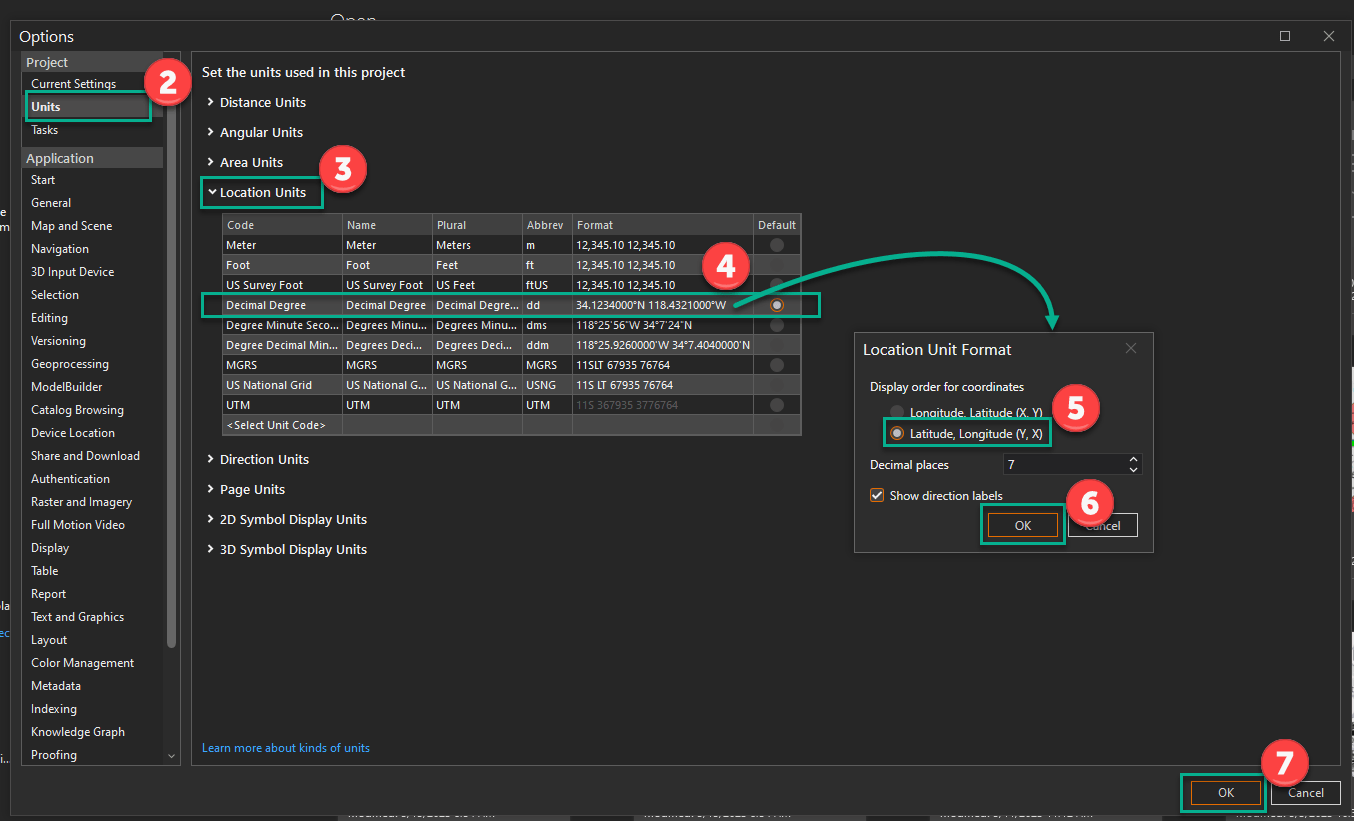
To change, or swap, the order in which they are shown in the map display, do the following:

- Open the Options dialog box by doing one of the following:
- Click the Project tab in an open project.
- Select Settings in the ArcGIS AllSource start pane.
- Click Units in the Options.
- Expand Location Units.
- Click the coordinate values in the Format field in the Decimal Degree.
- The Location Unit Format dialog box appears.
- Select Latitude, Longitude (Y,X).
- Click OK to close the Location Unit Format dialog box.
- Click OK to close the Options.
In your map, you should now see the coordinates displayed as latitude and then longitude. This will make it easier to read the coordinate display if you are used to reading latitude and longitude coordinates.

More options
You can also do any of the following:
- Swap the order of Degree Minute Second and Degree Decimal Minute coordinate display.
- Change the number of decimal places displayed for various coordinates.
- Change padding and separators for projected coordinate notations like Meter and Foot.
- Change the accuracy measure of MGRS and US National Grid coordinate notations.
Resources
- Set unit options (ArcGIS AllSource online help): https://doc.arcgis.com/en/allsource/latest/get-started/units-options.htm
Banner Photo by Alexander Andrews on Unsplash
Card Photo by Alexander Andrews on Unsplash


Article Discussion: