Last updated: 05/13/2025
The ArcGIS Spatial Analyst extension in ArcGIS Pro provides a broad range of powerful spatial modeling and analysis capabilities, like distance analysis, suitability modeling, terrain analysis, surface modeling, surface interpolation, hydrological analysis, and image classification. You can create, query, map, and analyze raster data; derive new information from existing data and perform integrated raster/vector analysis. Listed below are some resources to help you learn more.
Share your questions and awesome analysis stories with us at the Spatial Analyst Forum— We’d love to hear from you!
What’s New?
- What’s New for Spatial Analyst in ArcGIS Pro 3.5 (Blog)
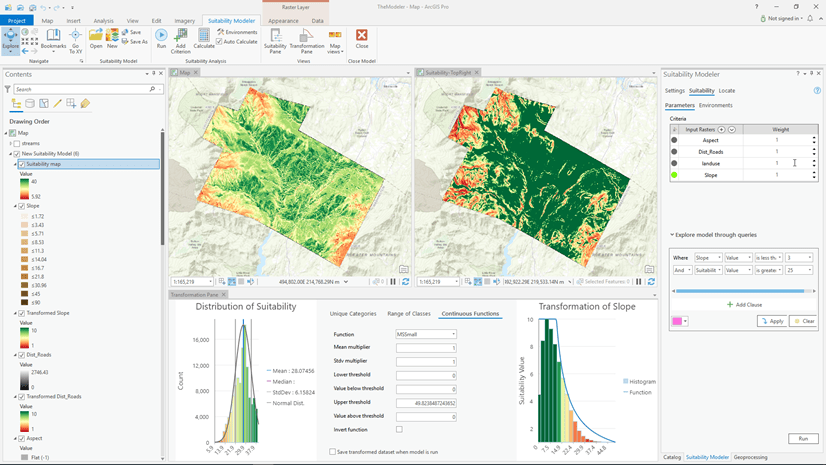
- Suitability Modeler: Changing the way suitability models are created (Blog)
- GPU processing with Spatial Analyst (Help)
New to Spatial Analyst? Start here:
- Getting started with Spatial Analyst (Esri User Conference 2024 Video, Help)
- ArcGIS ArcMap Spatial Analyst Tutorial (Help)
- Overview of the ArcGIS Spatial Analyst Toolbox (Help)
- Analysis environments and Spatial Analyst (Help)
- How the analysis window is determined in Spatial Analyst (Help)
Performing analysis with Spatial Analyst
Suitability modeling
- The new Suitability Modeler: Changing the way suitability models are created (Blog, Video)
- Finding the Best Locations Using the Suitability Modeling (Esri User Conference 2023 Video, Technical Workshop)
- Site a sustainable shrimp farm (Learn ArcGIS Lesson)
- Conceptual steps for creating a suitability map (Help)
- Engaging Citizens in Ocean Conservation: A Suitability Analysis for Coral Reef Ecotourism (Video)
- Calculate Drone Corridors for Package Delivery (Blog)
- Use suitability analysis to identify optimum flight corridors (Video)
- Evaluate Mountain Lion Habitat Suitability with a Raster Function Template (Blog)
- Build a Model to Connect Mountain Lion Habitat (Learn ArcGIS Lesson)
- Propose Wildlife Corridors for Key Species (Blog)
- Understanding the suitability modeling workflow (Case Study)
- Where are the best locations for a golf resort? (Case Study)
- Finding Optimal Locations: Suitability Modeling in ArcGIS Pro (Training)
Distance analysis
- Calculating Global Distances and Routes (Blog)
- Distance Analysis: Identifying Optimal Paths Using Rasters (Esri User Conference 2023 Video)
- Create a wildlife corridor with the new Least Cost Corridor tool in ArcGIS Pro (Blog)
- Connecting locations with optimal paths (Blog)
- Determining how distance is encountered by the traveler (Blog)
- Calculating the distance between locations (Blog)
- Distance Analysis Simplified (Blog)
- What’s New in the Spatial Analyst Distance Toolset in Pro 2.5 (Blog)
- Spatial approaches to determine accessibility (Blog)
- Creating accumulative cost surfaces using directional data (Blog)
- Doing more with Euclidean Distance: Barriers and Paths (Blog)
- Identifying the Best Paths with Cost Distance Analysis (Technical Workshop)
- Distance Analysis Using ArcGIS (Training), ArcGIS Pro (Training)
- Understanding cost distance analysis (Case Study)
Multidimensional analysis
- Multidimensional raster data (Help)
- Multidimensional Analysis in ArcGIS Pro (Video)
- Environmental Annotation of Occurrence Data Across Space and Time (Video)
Surface analysis
- Classify terrain with the new Geomorphon Landforms tool (Blog)
- New Surface Analysis Capabilities in ArcGIS Pro 2.7 (Blog)
- Creating surfaces (Technical Workshop)
Hydrological analysis
- Filling sinks in DEMs like an expert (Blog)
- Flood and Hydrologic Analysis with ArcGIS (Esri User Conference 2024 Video)
- Assess Flood Damage with Raster Analytics (Video)
- Creating Watersheds and Stream Network (Technical Workshop)
- GIS Techniques for Floodplain Delineation (Technical Workshop)
- Hydrologic and Hydrological Modeling (Technical Workshop)
- Creating a Hydrologically Conditioned DEM (Technical Workshop)
- Predict Floods with Unit Hydrographs (Learn ArcGIS Lesson)
Image classification
- Introduction to Imagery & Remote Sensing (Learn ArcGIS Project)
- ArcGIS Imagery Workflows
- Spectral Profiles: Improve Classification Before You Click Run (Blog)
- Introducing the Spectral Index Library in ArcGIS (Blog)
- Raster Classification with ArcGIS Desktop (Technical Workshop)
- Finding the Best Paths for Rovers and Humans on Mars (Esri News)
- Impervious Surface Mapping using Pro 1.4 – Part 1: Georeferencing (Blog)
- Impervious Surface Mapping Using Pro 1.4 – Part 2: Classification (Blog)
- Hands-on experience with the Image Classification Wizard ArcGIS Pro 1.3 (Blog)
- Pass the classification but hold the salt and pepper (Blog)
Python for Analysis
- Python: Raster Analysis (Esri User Conference 2023 Video)
- A Treasure Trove of Python Raster Functions (Blog)
- Writing Image Processing Algorithms Using the Python Raster Function (Technical Workshop, Video)
- Parallel Python: Multiprocessing with ArcPy (Technical Workshop, Video)
Integrating different workflows together
- Aloha! A GIS vacation (Case Study)
- Minimizing the environmental impact of wind farm installation (Case Study)
Extending analytical capability using script tools
Blogs
- Multidimensional analysis and visualization with the Space Time Kernel Density tool
- Calculating Global Distances and Routes
- Filling sinks in DEMs like an expert
- Doing more with Density tools: Understanding spatial patterns of data in ArcGIS Pro
- Fill NoData holes in raster data
- Multi-objective modeling with submodels using the Suitability Modeler
- Create a wildlife corridor with the new Least Cost Corridor tool in ArcGIS Pro
- Classify terrain with the new Geomorphon Landforms tool
- Connecting locations with optimal paths
- Determining how distance is encountered by the traveler
- Calculating the distance between locations
- Distance Analysis Simplified
- New Surface Analysis Capabilities in ArcGIS Pro 2.7
- Spatial approaches to determine accessibility
- Reclassify Raster Data in ArcGIS Pro Spatial Analyst Extension
- The new Suitability Modeler: Changing the way suitability models are created
- Introducing the Raster Cell Iterator
- Unleash the power of RasterCellIterator to perform custom raster analysis
- Creating accumulative cost surfaces using directional data
- Doing more with Euclidean Distance: Barriers and Paths
- Introducing the new resolution preserving cell size projection method
- Calculate Drone Corridors for Package Delivery
- Evaluate Mountain Lion Habitat Suitability with a Raster Function Template
- Propose wildlife corridors for key species
- Getting the most out of Zonal Statistics
- Executing Spatial Analyst Tools using ArcGIS Pro SDK
- Multiprocessing with ArcGIS – Raster Analysis
- Interpolation in the presence of barriers
- Using interactive features with Spatial Analyst tools
- How to extract raster values at point locations?
- Performing analysis with the Con tool.
- Learn spatial analysis techniques with scenario-based case studies
- Are you getting GPU error while executing the Viewshed 2 tool?
- Why your output raster is larger than your environment extent?
- How large a DEM can the TopoToRaster tool create?
Readily Available Data
- Living Atlas of the world (Data)
- Understanding Working with Elevation Services (Technical Workshop)
Esri Conference Presentations at a glance!
Suggested Books
Harder, C. (2015). The ArcGIS Book: 10 Big Ideas about Applying Geography to Your World. Esri Press.
Mitchell, A. (2012). The ESRI Guide to GIS Analysis Volume 3; Modeling Suitability Movement and Interaction. Esri Press.


Commenting is not enabled for this article.