As a new member of the ArcGIS GeoAnalytics Server team, I have quickly learned about GeoAnalytics and what it has to offer. GeoAnalytics enables users to leverage distributed computation for big data analysis. If you feel as I did, these new terms might be intimidating. Spoiler alert: GeoAnalytics is not scary – it’s extremely exciting! GeoAnalytics offers you the familiar ArcGIS experience: GeoAnalytics Tools are accessible through ArcGIS Pro and the ArcGIS Enterprise portal, and if you are a developer (or a Python whiz-in-training like myself), you can leverage the REST API, the arcpy module, or the newly introduced ArcGIS API for Python. In all cases, GeoAnalytics distributes analysis across your GeoAnalytics Server on one or many machines. This allows for tailored analysis as you gear your server settings to work most efficiently for you – tell me that isn’t awesome! ArcGIS Enterprise 10.6 introduces three exciting new GeoAnalytics tools – Calculate Field, Detect Incidents, and Geocode Locations from Table. I’ve had the opportunity to test out (and have some fun with) Geocode Locations from Table, and I’m excited to share it with you!
All about geocoding in ArcGIS GeoAnalytics Server 10.6
Geocode Locations from Table is ideal for you if you are maintaining address data – it is the perfect kick-start to mapping and visualizing your data by giving your addresses a place on a map! Geocode Locations opens up many opportunities to ask questions of your data, and conduct further spatial analysis. That makes us GIS analysts very excited about this tool! Here is a quick sneak-peek of how Geocode Locations from Table can transform your data from address name to spatial coordinates: 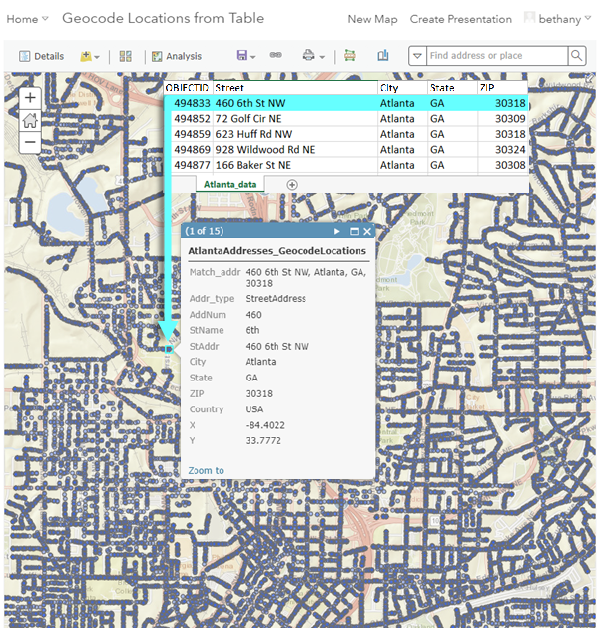
One unique aspect of GeoAnalytics is that it allows us to analyze patterns in large data that would otherwise be hidden, or cumbersome to interpret. For example, with Geocode Locations from Table, you can:
- Gather millions of location records and explore marketing strategies in spatial detail. This means understanding not only what to market, but where. I’ll give an example: A large sporting goods company is looking to expand based on proximity to sports complexes and on customer feedback. For use in analysis, they have feedback containing millions of consumer addresses, and average amounts spent on sports equipment and sports facilities. Geocode Locations can process the addresses in the feedback dataset to spatially orient customer locations on a map. From here, you can investigate high interest and high spending areas where a sporting goods company would prosper.
- Detect fraudulent insurance claims. Large insurance companies insure millions of properties. This could become problematic during disaster response, when companies are overwhelmed by the influx of customer claims. Response is time-sensitive, and insurance companies need a way to filter out fraudulent claims: Cue Geocode Locations from Table! The company’s GIS analyst can use this tool to explore spatial relationships between geocoded property locations and disaster footprints. Property locations that do not intersect with disaster footprints can be flagged as an outlier and inspected as a fraudulent claim. This means prioritizing response based on the property’s spatial relationship with the disaster. How extremely useful is that?
- Overcome ever-growing population hurdles with effective city planning. In gathering the addresses of all types of locations – such as housing, grocery stores, and department stores – a city’s GIS analyst may quickly realize they have compiled an exceptionally large dataset. Processing this dataset with Geocode Locations from Table enables the city to gain holistic understanding of city structure. For example, a city may have many grocery stores, but limited affordable housing for consumers, and needs to find out, “where do these patterns exist?” Visualize these patterns using ArcGIS Enterprise portal by symbolizing location types and population densities to predict demand from customer feedback.
Try it out
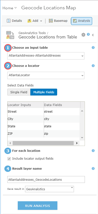
To get started with Geocode Locations from Table, all you need are the addresses you want to locate and a locator (parameters 1 and 2 outlined in red). A quick note on locators– they can be configured specifically to your location and data, or they can be geared towards a larger audience with various location formats. It is up to your organization to decide what you would like to use! Let’s have a look at the interface that guides your geocoding journey with an Atlanta example:
Once you have provided the input table and locator parameters, you are able to run the tool and see your results.

And voila! By placing your locations on a map via Geocode Locations from Table, you have initiated the process of data exploration for you and your organization. Now that we have eliminated the fear of GeoAnalytics and big data, get out there and geocode!
Learn more about Geocode Locations from Table

Commenting is not enabled for this article.