As many have noticed, the Spatial Analyst toolbar changed from ArcGIS 9.x to 10. This change is described in the What’s New and Quick tour documentation, but questions about it still come up, so we wanted to share some additional information.
What changed?
Basically, the drop-down menu that listed the 30 selected Spatial Analyst operations was removed. The interactive exploratory tools (Contour and Hillshade) remain as they were. The full scope of Spatial Analyst functionality remains as before in the 170 geoprocessing tools which are available in the Spatial Analyst toolbox.
At ArcGIS 10 you can now easily customize and create your own toolbars and dropdown lists of the geoprocessing tools you use most frequently using the standard Windows® toolbar Customize functionality. The old operations from the toolbar were removed to eliminate the confusion many encountered as a result of the toolbar and toolbox having different environment controls. Now, the tools you add to the Spatial Analyst toolbar will honor the same geoprocessing environment as the rest of the system.
We have also greatly improved the overall Search capabilities of ArcGIS, particularly for Finding tools. If you search for tools in ‘tool mode’, you can type partial names, use the arrow keys to navigate to the autocomplete entry you are looking for, and then hit Ctrl+Enter to quickly launch the tool.
How are the capabilities of the old toolbar accessible?
Recently added to the web Help for ArcGIS 10 is a topic that gives a mapping of the capabilities available in the 9.x Spatial Analyst toolbar to the equivalent geoprocessing tools in ArcGIS 10.
Accessing 9.x Spatial Analyst toolbar functionality in ArcGIS 10
Interactive tools on the toolbar
The Contour and Histogram interactive tools remain on the Spatial Analyst toolbar and operate as before. These tools will be activated once a valid raster dataset has been added to the TOC (and the extension enabled, of course).
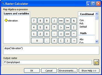
What about the Raster Calculator?
The Raster Calculator in the toolbar for ArcGIS 9.x has been replaced with the Raster Calculator geoprocessing tool in ArcGIS 10. As you can see below, the new Raster Calculator is quite similar yet a little nicer than before:
| Calculator in ArcGIS 10.0 | Raster Calculator in ArcGIS 9.3.1 |
|---|---|
 |
 |
This new tool allows you to better integrate Python into your workflows in ModelBuilder. You will also have consistent results from Raster Calculator and ArcPy as a result of this integration with the geoprocessing environment. Follow these links for more information on How Raster Calculator works and Building expressions in Raster Calculator.
Customizing and adding tools to the Spatial Analyst toolbar
You now have much more control over and can customize any toolbar in ArcGIS. This means you can add whatever tools you wish to the Spatial Analyst toolbar. On top of that, by adding menus and submenus, you can even create a tree structure with a customized organization of tools that suits your particular workflows. In fact, if so inclined, you could even re-create the old toolbar structure.
Here are some links that will help you customize the toolbar to your liking:
Creating a new toolbar
Adding a command to a toolbar or the main menu
Moving a command on a toolbar
Adding and removing tools on menus and toolbars
Adding a new, empty menu to a toolbar
Changing the display type of a command

Commenting is not enabled for this article.