Stitching together spreadsheets is fun right?
Ask anyone who works with field data and you will quickly learn about their creative process to distill piles of data into useful information. In my role as the Conservation Account Manager at Esri, I encounter a proliferation of these processes. Data management is a difficult task so I am always inspired when I encounter individuals infusing their field data collection efforts with technology.

One such an individual is Ricky Jones the Technology Manager at Adventure Scientists, a non-profit organization, that equips partners with data volunteers collect from the outdoors. This partnership plays a crucial role in addressing data gaps for environmental and human health challenges. Robust data collection, volunteer coordination, and saving time are all concerns that Ricky wrestles with on a regular basis. Like many non-profit technologists, Ricky also struggles with limited resources, a small team, and no shortage of passionate volunteers.
Ricky’s journey with applying the ArcGIS Platform at Adventure Scientists started with a simple phone call and evolved into bringing together a solution using ArcGIS Hub, ArcGIS Online, and Esri’s mobile tools for the following priority projects:
Tracking Timber
https://www.adventurescientists.org/timber.html
The team and volunteers at Adventure Scientists are collecting thousands of leaf, seed, and wood samples to create databases of the chemical and genetic signatures of tree species throughout their ranges. Illegal logging is on the rise in the US as well as around the world, as timber thieves target valuable trees in national forests and even in private backyards.
This information will power new tools to reveal the origin of any sample of timber––taking away illegal loggers’ ability to sneak poached trees into the world’s wood supply. Law enforcement can then use the databases to catch tree poachers by checking whether wood really comes from where the seller says it does. Over 300 volunteers took 6000 samples throughout the 2019 field season of this project.
The ArcGIS platform enables Ricky to bring together volunteers, streamline data collection, and report out progress. This provides both internal staff and volunteers with dynamic information products which in turn helps to inspire a greater sense of impact and accomplishment as well as inspire new ideas.
Love the outdoors, and a little location-enabled data collection? Reach out to the Timber Project team and get involved by clicking here.
Timber Tracking Map
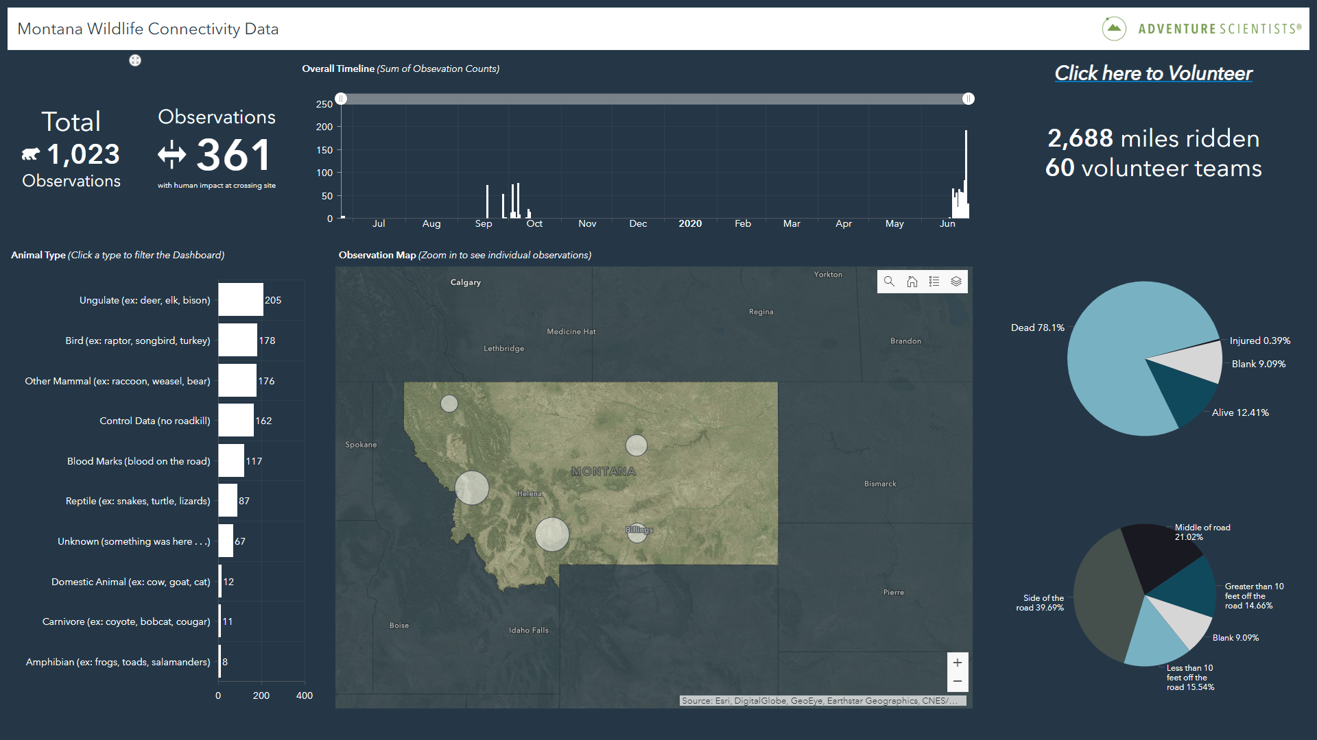
Montana Wildlife Connectivity
https://www.adventurescientists.org/montana-wildlife-connectivity.html
Did you know that more than 365 million animals are killed, 29,000 humans injured, and $8.4 billion in damages incurred every year in the United States alone as a result of wildlife-vehicle collisions? Humans and animals deserve better. Adventure Scientists is partnering with the Montana Department of Fish, Wildlife and Parks, and the Montana Department of Transportation and many volunteers to focus efforts on understanding barriers to wildlife connectivity and identify areas of concern in order to plan for and mitigate these in the future.
The ArcGIS platform enables Ricky to provide volunteers with a digital identity. Digital identity gives them access to focused field mobility tools and data collection forms in both connected and disconnected environments. This in turn reduces the time it takes to review data and correct errors by providing additional transparency.
Have legs? Will cycle to save wildlife? Reach out to the Wildlife Connectivity team and get involved by clicking here.
Wild and Scenic Rivers
https://www.adventurescientists.org/rivers.html
The National Wild and Scenic Rivers System contributes 10% of drinking water throughout the United States. In addition, these rivers are essential for their cultural, recreational, and natural value. However, water quality on the vast majority of these rivers has not been comprehensively surveyed. Adventure Scientists is partnering with over 40 States and 4 Federal agencies to identify priority stressors impacting the environmental health of wild and scenic rivers.
The ArcGIS platform will enable Ricky to coordinate volunteers across wide geographic spaces and normalize data collected to rapidly share outcomes with the variety of partners involved in this project.
Love the outdoors? Don’t mind getting your feet wet and hands dirty? Reach out to the Wild and Scenic Rivers team to get involved by clicking here.
Priority Wild and Scenic Rivers
2020 Esri Virtual Users Conference
This year Esri invited Ricky from Adventure Scientists to share their technology journey in a spotlight video. If you haven’t registered yet you can do so here. Once registered you can watch the spotlight video during the Esri Virtual Users Conference from July 13 – 16th click here to watch Ricky talk about Scaling Your Data Collection (link will be live soon).

Article Discussion: