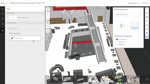
This release of ArcGIS Online initiates new possibilities for Scene Viewer users. So far, users have been able to author and visualize scenes that feature a tremendous volume of 3D content streamed performantly over the web. Scene Viewer users have been able to interact with that data through navigation and interactive analysis tools, and they’ve been able to produce applications and experiences with those authored scenes. This release presents a major milestone for Scene Viewer users: editing point, line and polygon feature layers. We’ve also added improvements to the user interface, the ability to author layer pop-ups, and the ability to save styling and pop-ups authored in Scene Viewer to your scene layers.
Designer Bar
So much of what makes 3D Web GIS approachable to the larger GIS community is that it’s supported by a large user base and their investment in familiar patterns in ArcGIS. It’s one of the reasons we’ve incorporated Map Viewer user interface elements into Scene Viewer. The ‘Designer Bar’ is a dark grey expandable set of icons on the left where users can access scene layers, slides and scene properties when signed in. Much of the user interface in the Designer Bar should be familiar as it activates features (Layers, Slides, Properties, Save) that have the same functionality as in previous releases.
Editing in Scene Viewer
You’ll find a completely new feature in the Designer Bar when a user adds an editable feature layer to the scene. An Edit icon now appears and can be activated to present the edit user interface. The Edit dialog presents a snapping user interface, and the feature layer’s edit template. When the edit dialog is activated, you’re able to either select and edit existing editable features, or you can begin creating new features in the scene.

A few helpful tips:
- It’s best to have the extent and camera angle ready to begin editing a line or polygon feature, but it is possible to activate other interactive tools, slides and to navigate while editing a feature.
- Keyboard navigation is especially helpful for navigating while editing large and detailed features.
- While sketching a feature layer, placed vertices borrow height (Z) values from the underlying geometry. While it’s convenient, it may lead to some unintended consequences when sketching over complex geometries like integrated mesh scene layers. Check sketched or completed line and polygon features from multiple angles to ensure the feature is drawn as intended.
- Double-clicking finishes a sketched feature’s geometry. Editable attributes are presented on the left, and you must click “Add” on the bottom of the Edit dialog to add that feature to the feature layer.
- This is experience is made to be taken underground and inside of other complex data, so we encourage you to experiment with true 3D editing use cases. The level selector in the Building Explorer widget also makes for a remarkable experience while editing features inside of a building scene layer.
Snapping
Snapping is available in a traditional sense for points, lines and polygons, and the user can select features that they can snap to in the snapping user interface. While drawing lines and polygons, you may also notice snapping guides to help a user draw parallel or perpendicular lines from snapping layers and sketched features. This can be very helpful for drawing features like building footprints, and snapping also helps ensure that the features being drawn have the appropriate topological connection to other features.

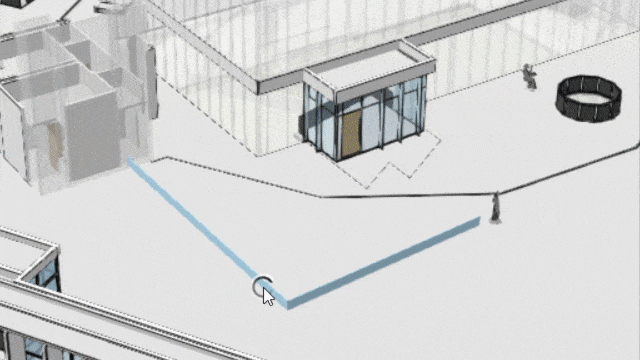
Feature Transform and Vertex editing
Once line or polygon features have been added, they are editable with new editing handles. With the “Click feature to edit” tool active, a single click on an editable line or polygon feature presents feature transform handles, and a second click on the feature presents a vertex editing handles.
Feature transformation allows a feature to be rotated, moved, scaled, and for the entire feature’s Z value to be changed.
Vertex editing allows a feature to be moved, and for the entire feature’s Z value to be changed. Vertices can be moved individually with larger orange spheres signifying their handles. Not only can vertices be moved horizontally, but the orange arrow allows the vertex to be moved vertically. Smaller orange spheres between vertices enable a user to add a new vertex.
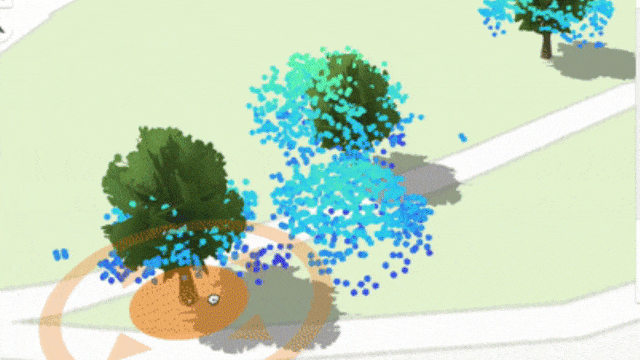
Point feature layers symbolized with 3D webstyles can also be added and edited. When the 3D webstyle refers to attributes for height and rotation, there are handles to place, scale and rotate the 3D webstyle. This is useful for placing assets and trees like the example below. You can also add your own 3D models into ArcGIS as 3D webstyles.
While this is exciting and new to see web editing in a new way, this is a reminder that feature layers are feature layers. Feature layer data in a 3D GIS is not something so extraordinary that it exists outside of GIS workflows. Whether they’re edited in 2D or 3D, feature layers are accessed and managed with the same patterns learned in ArcGIS. Scene Viewer presents new ways of symbolizing and contextualizing feature layers, but Map Viewer can consume the same features for a 2D view of that data. This makes the prospect of a simultaneous 3D and 2D view of feature layer data feasible through apps like Experience Builder and the 3D Viewer Instant app.
Pop-up authoring
Another feature added to Scene Viewer is the ability to author pop-ups for feature layers and scene layers. The capability is identical to Map Viewer, where users can add a fields list, chart, image or text elements. This makes the pop-up authoring experience much more approachable, and understandable pop-ups are encouraged as a best practice.
Save Layer
Scene layers can be styled to reflect certain attributes, to visualize points with 3D symbology, and also to make a choice for how point clouds are depicted. Also, now with pop-up authoring, there’s a lot of potential visualization capability that can be authored directly into a scene layer. Now users can save the styling and pop-up choices right into the scene layer with “Save Layer”, accessible on the layer options. Users must be the owner of the scene layer to be able to save authoring choices into the scene layer.
We hope that you are as excited as we are to begin editing feature layers in Scene Viewer. Even though this is an initial release of 3D editing on the web, there is a lot of potential for how this capability will continue to grow and be incorporated into new workflows. With this new features, traditional GIS users and 3D-first users will find and grow familiar patterns of use and adoption for workflows.

Article Discussion: