Is your GIS living up to its potential? With today’s technology, your GIS can be so much more than a system of record. I know GIS is great at storing your authoritative data but it’s also good at sharing your data and creating actionable information from your data. Today, GIS is a system of record, a system of engagement and a system of insight….and it’s easier than ever to implement!
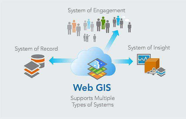
There are many definitions for system of engagement. Some define it as a system used directly by employees. Others say it as a system that encourages and enables peer interaction. At Esri, a system of engagement is defined as a system that manages and promotes user collaboration and interaction. It overlays and complements an organization’s investment in a system of record by providing easy access to data as well as easy to use applications that enable collaboration across your organization.
How do you implement a system of engagement? You have to start with Web GIS. Now is the time. Web GIS modernizes your workflows by using web services to deliver data and capabilities. It enables a whole suite of applications that support the work that you do.
For example, optimize your field operations with apps that improve collaboration and streamlines project coordination by providing the same authoritative data to field and office staff in real-time. Access to the same information at the same time can reduce errors, boost productivity, and save money.
What is your data telling you? This is where a system of insight becomes important. A system of insight facilitates organizing, transforming, and analyzing your data. With analytics you can discover secrets in your data, evaluate trends, and even integrate non-spatial data…resulting in actionable information. Analysis can be performed on the desktop, online, or within Insights for ArcGIS. Whatever your need is, there is an analytical tool that can help.
Are you getting the most out of your GIS?
If not, Esri’s water team is always willing to help.
Christa Campbell
Industry Specialist – Esri Global Water Practice

Commenting is not enabled for this article.