If you find yourself in the repetitive loop of preparing data and then publishing the latest copy of it as a feature to ArcGIS Online, you need to familiarize yourself with ArcGIS Data Pipelines. Data Pipelines simplifies data preparation workflows, offering a visual, drag-and-drop interface to connect, clean, and transform your data. The results are written out to feature layers in your ArcGIS organization, ready for use in your visualization and analysis workflows. More importantly, Data Pipelines supports built-in task scheduling functionality and other ways to automate data pipelines runs, such a using Microsoft Power Automate, helping you to ensure that feature layers are kept up-to-date without any repetitive manual effort or scripting expertise.
Before we delve into the new improvements coming to ArcGIS Data Pipelines in the June update, let’s take a minute to recap some of the recent updates to ArcGIS Data Pipelines. The previous update in February 2025 brought us a new tool, Summarize attributes, the ability to filter your data with dynamic time queries, the ability to sort and search your notes, and more. Before that, the November 2024 update introduced data pipeline notes, the new Pivot and Dissolve tools, and the ability to overwrite existing layers as an output method. Now that we’ve seen some of the recent features and enhancements that have come, let’s dive into the new improvements in the June 2025 update.
What’s New
This update to ArcGIS Data Pipelines is ramps up the possibilities for data integration in ArcGIS Online, with two new input data sources, a new data engineering tool, and an enhanced preview experience for complex field types. Each enhancement was driven by user’s feedback, so we encourage you to continue sharing your ideas and feedback with us through Esri Community.
Let’s get into the details!
Secured URL support (beta)
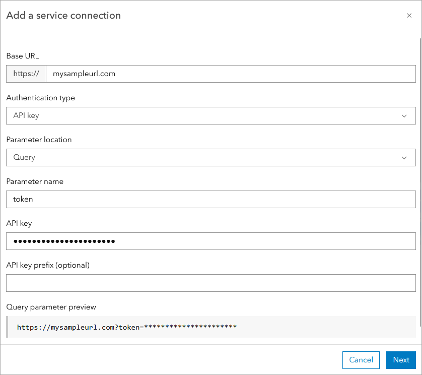
You’ve asked for it and we’ve listened. You can now connect to secure URLs like open data portals that require a password or commercial REST APIs that use token-based access. This new input significantly expands the range of sources you can integrate with ArcGIS Online, without any need for a custom solution. When connecting to your secured URLs, your credentials, secrets, or tokens will be securely stored in a new service connection item. Service connection items enable you to easily and repeatedly connect to your secured data. This feature is in beta.
Note: This feature is currently in beta, meaning it is still under active development and may be subject to change. Technical support is not available while features are in beta, and feedback should be submitted via this Esri Community Forum to help guide future improvements or seek support.

Databricks support (beta)
There’s another new input data source in the June 2025 update that we are excited to share. One of the top requested ideas on Esri Community was the ask for us to support connecting to data in Databricks. In this release, we have added this support, allowing you to bring data from your Databricks warehouse into ArcGIS Online via a data pipeline.
Note: This feature is currently in beta, meaning it is still under active development and may be subject to change. Technical support is not available while features are in beta, and feedback should be submitted via this Esri Community Forum to help guide future improvements or seek support.
Clip tool
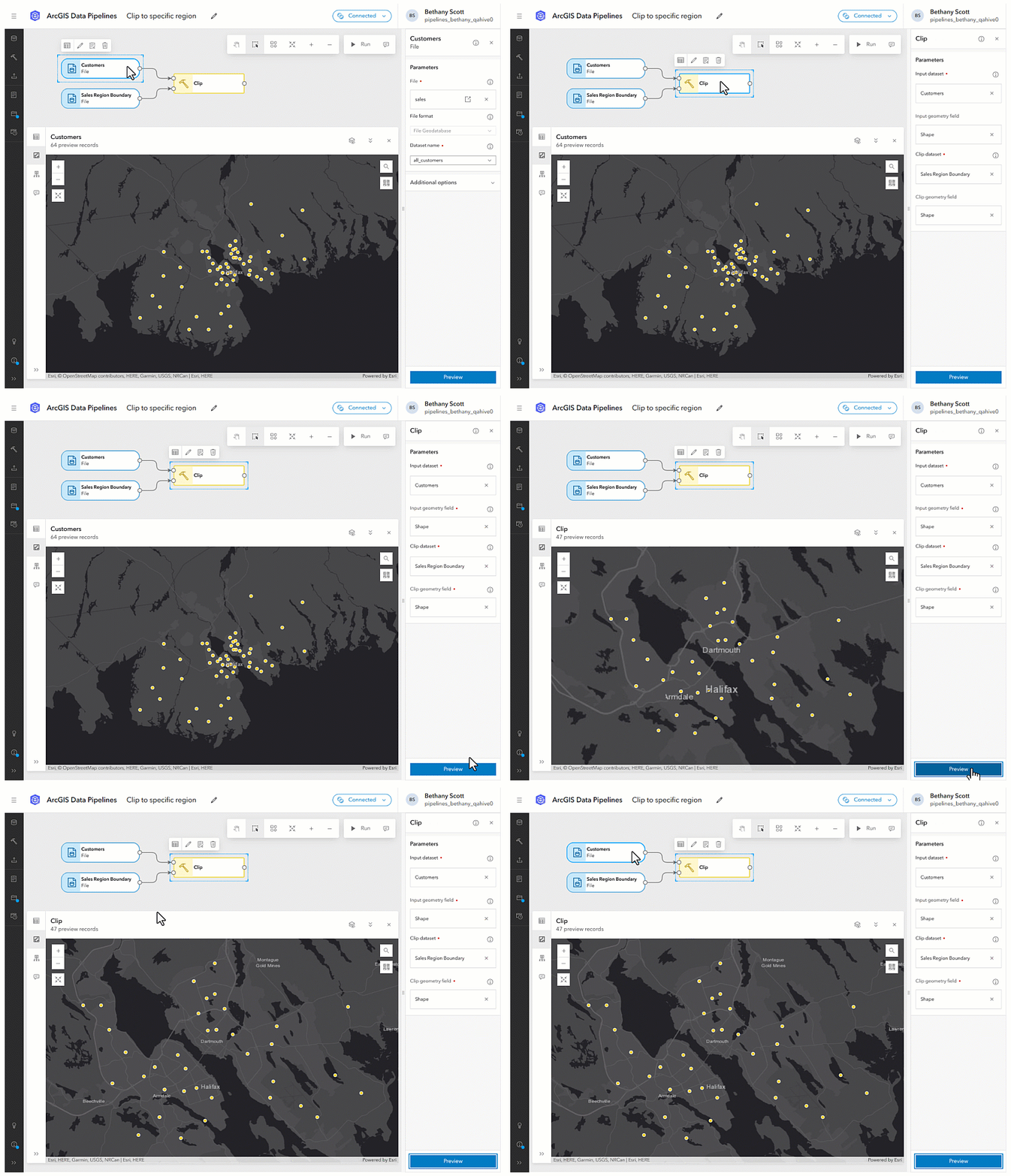
The Clip tool allows you to cut portions of geometries in one dataset using one or more geometries of another dataset, like a cookie cutter. This data processing tool gives you the ability to more easily limit data to a specific area of interest. For example, you can use the Clip tool to extract points that fall within a specific geographic boundary for targeted analysis, such as identifying your customers who live within a specific sales region.

Key-pair authentication for Snowflake
Snowflake announced that they will block single-factor password authentication later this year. When multi-factor authentication (MFA) is enforced on a user’s Snowflake account, connections to Snowflake in ArcGIS Data Pipelines using basic authentication will stop functioning. To ensure our users can continue integrating data from Snowflake with ArcGIS Online, we have added support for using key-pair authentication in this release. You will be able to establish new connections to Snowflake using key-pair authentication, or you can also update existing data store items created using basic authentication to switch to this authentication type. For more information on Esri’s recommendations to mitigate potential disruptions due to Snowflake’s upcoming multi-factor authentication (MFA) enforcement, please refer to this Technical Support article.
Enhanced schema preview for complex fields
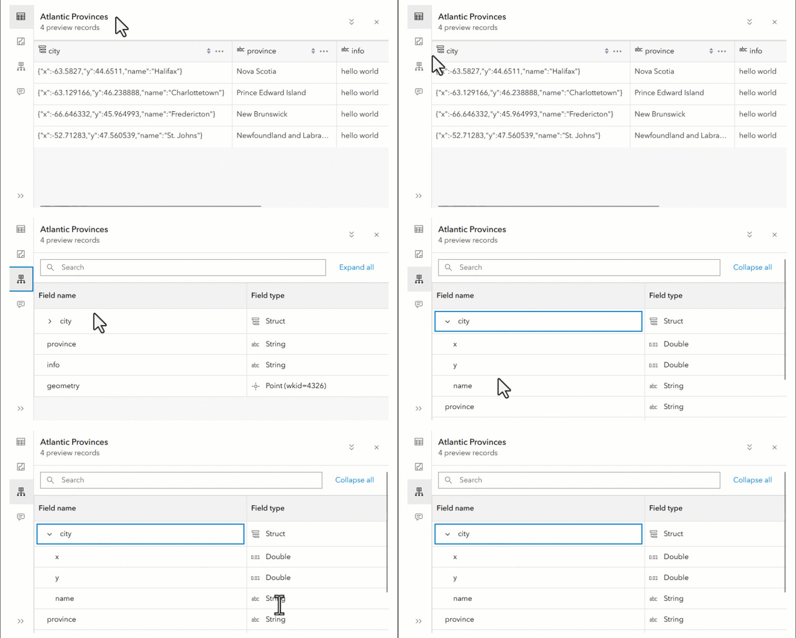
Data Pipelines allows you to preview data at every step of your data pipeline, with support for previewing the dataset’s table (attributes), geometry (locations on a map), as well as the schema (data structure definition).
In this update, we have enhanced preview experience for complex field types, or provide in-depth insight into subfields and subtypes within struct, array, or map fields when previewing the data’s schema. For example, if you have a struct field named City containing values such as {"x":-63.5827, "y": 44.6511, "name": "Halifax"}, the schema preview will reveal subfields of x (double), y (double), and name (string) within the City field.

This enhancement allows you to delve into complex data structures, enabling better interpretation and schema design for optimized data processing.
Additional resources
Whether you’re just getting started with ArcGIS Data Pipelines or looking to sharpen your skills, we’ve got you covered. Here are some helpful resources to explore:
- Explore what’s new: Check out the What’s New documentation to see the latest updates and enhancements.
- Watch a demo: This webinar recording walks through key capabilities and shows how Data Pipelines can streamline your workflows.
- Read more on the blog: Dive into other ArcGIS Data Pipelines blog posts that highlight use cases, tips, and best practices.
- Try it yourself: Follow this step-by-step tutorial to build your first data integration workflow.
- Get answers: Visit the FAQ or join the conversation in the Data Pipelines Community—our team is there to help.
- Stay in the loop: Don’t miss the What’s New in ArcGIS Online (June 2025) blog for broader platform updates.
We’re always listening! If you have ideas, questions, or feedback, drop by the Data Pipelines Community and let us know what you’d like to see next.


Hi team, will this be available for ArcGIS Enterprise or just ArcGIS Online