Approximate Reading Time: 5 minutes
The ArcGIS Pro 3.2 release includes several enhancements to geoprocessing tool controls to improve their usability and make room for more capabilities that will boost your productivity:
- Selection and Filter Tip – Input parameters display a message when the layer or table has a selection, filter, or highlight. It also now includes a toggle to honor or ignore the selection, highlight, or filter
- Processing Extent Controls – You can find the extent controls in tool parameters, tool environments, and project environment settings. The ArcGIS Pro 3.2 release includes an enhanced extent control with an updated interface and a few new features.
- Field Map – This control is available in several geoprocessing tools, including Export Features, Spatial Join, Merge and more! Check out this blog to for an in-depth review of the changes made to the field map.
Selection and Filter Tip
The ArcGIS Pro 3.0 release introduced the Geoprocessing Selection and Filter Tip that displays under layer and table view input parameters. This message informs you when an input has an active selection or filter (definition query, time filter, and range filter) and how many records will be processed when you run a tool.
You can use these options to work with a subset of the records within a dataset. But what if your analysis requires you to analyze the whole dataset as well as subsets of your data?
Introducing the Toggle
Instead of removing your selection or filter, only to re-add it in a later step, in ArcGIS Pro 3.2, the tip includes a  toggle. This enhancement will increase your productivity by allowing you to process your data in multiple ways directly from the tool dialog without changing the state of your layer or table.

You can turn the toggle off to process all input records (ignoring the selection or filter) or on to process a subset of your records. Turning off a selection or filter from the tool dialog will not remove it from your layer. Instead, it will only affect how many records will be processed when you run the tool.
Note: If a layer has a selection and filter, only the selection is described in the tip and used by the tool. Turning off the selection will result in all records being processed.
Support for highlighted records
In ArcGIS Pro 3.2, Geoprocessing tools support highlighted records in a selection, so you can identify and process further subsets of an already defined selection set. You can highlight records in a table view by first creating a selection in the table view or map, then in the attributes table, click  Show selected records and click-and-drag your pointer over the rows you want to highlight.
Note: If you toggle off the highlighted records, the tool will run using all the records in a layer, not the selected records.
Watch this short clip to learn more about the updated Selection and Filter Tip in Pro 3.2:
Extent Control
In ArcGIS Pro 3.2, the geoprocessing extent controls have a new look, more options, and other additional features.
The redesign makes the different ways you can set the extent readily accessible in an icon bar at the top of the control.
Note: Hover over each icon to view information about it.
 and 3.2 (right)")
Like in earlier version of ArcGIS Pro, you will find 4 different extent options in tool parameters:  Current Display Extent,
  Extent of a Layer,
  Browse, and
  Reset Extent. The extent control in Envrionment Settings has 2 additional options that will determine the extent at tool run-time:
  Intersection of Inputs and
  Union of Inputs.
The Extent of a Layer drop-down includes all map layers, and a new, Extent of data in all layers option. You can use this option to get the combined extent from all active map layers, excluding the basemap. Use this option to remove some of the guesswork if you want to get an extent that represents multiple layers in your area of interest.
The extent control now displays the Extent Coordinate System under the extent, so you will always know what coordinate system the extent values are drawn from. Extent coordinates can look very different depending on the coordinate system being used. The extent control generally uses the same coordinate system as the active map, except when you Browse to an extent. If you Browse to the extent of an existing dataset, the control will display the X and Y Extent in that dataset’s coordinate system.
Check out this video to see the new geoprocessing extent control in action:
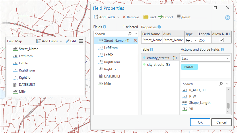
Field Map
The geoprocessing field map parameter is found in multiple tools and is used to transfer or match attributes from one dataset to another. You can also use it to edit a field’s properties and perform basic calculations or other actions on fields before you run a tool.
In ArcGIS Pro 3.2 the field map’s interface was redesigned to improve the control’s accessibility and increase its capabilities.
Note: The FieldMap and FieldMappings objects in Python did not change.
 vs 3.2 (right)")
The updated field map control lists the field names with an icon that represents each field type (text, integer, double, float, etc.). You can also choose to list by field aliases,  Export the field map to save it as a string file, or
  Load an existing field map you’ve already saved.
One of the most notable differences from earlier versions of the field map is that field mapping or matching tasks now occur in a separate, Field Properties window. You can access the Field Properties window by clicking the  Edit button at the top of the control or to the right of a selected (or hovered) field.

In the Field Properties window, you can view or edit a field’s properties, source fields, and any associated actions (i.e., merge rules) in one place. The new interface displays each source field as a tag that you can add, remove, or reorder. The Merge Rules are now referred to as Actions, which you can use to determine how one or multiple source fields will be transferred to the output or updated field.
Continue reading to learn more about the field map parameter in ArcGIS Pro 3.2.
Summary
We redesigned these controls to make them easier to use and provide more options. We hope you upgrade to ArcGIS Pro 3.2 so you can take advantage of these updates!

Article Discussion: