Many new and improved capabilities are available to the Spatial Analyst extension in ArcGIS Pro 2.7. At the top of the list are two brand new capabilities, the Storage Capacity tool in the hydrology toolset and the Surface Parameters tool in the surface toolset. In addition, new capabilities and performance improvements are available across a broad range of analytical areas.
Where do I get it?
ArcGIS Pro 2.7 was released on December 16, 2020.
To see a complete summary of all the changes that have been made for this release, have a look at What’s New for ArcGIS Pro 2.7.
This release also sees the introduction of a version switcher in the web help content. In any topic, click on the Other versions drop-down to see the help content for the previous release.
What’s changed for Spatial Analyst?
Listed here are the main functional areas that have been improved over the last release:
- Density
- Distance
- Generalization
- Hydrology
- Overlay
- Segmentation and classification
- Surface
- Zonal
- ArcPy
1. Density analysis
The Kernel Density tool now supports the ability to use the geodesic method to calculate the density with a barrier feature. This creates better results for point features over a large extent. In the previous release, barriers were only supported for the planar distance method. The Kernel Density raster function now supports the ability to specify a barrier input.
2. Distance analysis
A new parameter was added to the Optimal Path As Line tool. This option allows you to choose to create overlapping paths, or to now produce nonoverlapping paths that can be used for networking.
Performance has been improved for the planar distance method for the Distance Accumulation, Distance Allocation, and Optimal Region Connections tools as well as the Distance Accumulation and Distance Allocation raster functions. The performance has also been improved for the Least Cost Path raster function.
3. Generalization analysis
The Boundary Clean tool now supports parallel processing for improved performance on larger datasets. This ability to smooth the boundaries between zones in raster data is now also available as the new Boundary Clean raster function.
4. Hydrology analysis
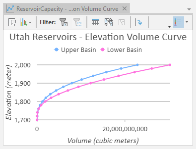
The new Storage Capacity tool creates a table and optional chart of elevations and corresponding storage capacities for an input surface raster based on a zone input. It calculates the surface area and total volume of the underlying region at a series of elevation increments.

5. Overlay analysis
The Locate Regions tool has significantly improved performance compared to previous releases. This tool is a useful part of a suitability workflow to identify the best regions that meet specified size requirements and spatial constraints.
6. Segmentation and classification analysis
The Export Training Data For Deep Learning tool has two new options available for the format of output metadata tables, Multi-labeled Tiles and Export Tiles.
7. Surface analysis
Some significant new capabilities for surface analysis are available to Spatial Analyst in ArcGIS Pro 2.7.
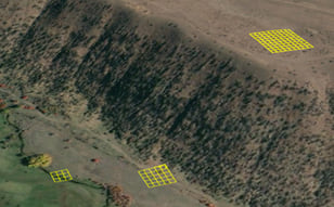
The new Surface Parameters tool determines various parameters of a raster surface such as aspect, slope and several types of curvature. These parameters are calculated on a cell-by-cell basis, by fitting a local quadratic or biquadratic surface around each target cell. You can define a specific neighborhood size to use for the calculations, or to have the tool to allow the neighborhood size to vary with local landscape changes.

There are two additional tools now available for surface analysis. Use the Add Surface Information tool to add various surface elevation properties to the attribute table of a feature class. Use the Interpolate Shape tool to convert 2D point, polyline or polygon feature class into a 3D feature class by interpolating z-values from a surface.
8. Zonal analysis
For zonal statistics analysis, it is now possible to calculate median and percentile statistics for floating point input rasters. For the percentile type, a new parameter is available that specifies the method of percentile interpolation to be used when the number of values from the input raster to be calculated are even. Also supported now is multidimensional processing for inputs with different dimensions.
These changes are available for the Zonal Statistics and Zonal Statistics as Table tools and the Zonal Statistics raster function.
9. ArcPy functions & Geoprocessing functions
Following is the list of updates made in the Spatial Analyst module.
ArcPy functions
The following new ArcPy functions are available in the arcpy.sa module in this release, listed by category:
- Band Indices—BAI, NBR, NDBI, NDMI, and NDSI
- Classification—Classify, LinearUnmixing, RegionGrow, and SegMeanShift
- Conversion—RasterizeFeatures
- Reclass—ZonalRemap
A Spatial Analyst license is required to use the entries in the Classification category. The entries in the Band Indices, Conversion and Reclass categories do not require any extension license.
Geoprocessing functions in Pro 2.7
The following new geoprocessing functions are available in the arcpy.sa module, listed by toolset:
- Hydrology—StorageCapacity
- Surface—AddSurfaceInformation, InterpolateShape, and SurfaceParameters
Spatial Analyst resources
Refer back to the Spatial Analyst resources blog to keep tabs on current developments and to find links to useful and interesting content. Here are some recent posts that you might find interesting:
Summary
2020 has been different for all of us, to say the least, but working from home has not stood in the way of the Spatial Analyst team making new and improved capabilities available to you! Check out the new ArcGIS Pro 2.7 (December 2020) release and try out the new capabilities. Share your views, analysis stories, suggestions, and feedback with us on the ArcGIS Spatial Analyst Geonet page.

Commenting is not enabled for this article.