With the release of ArcGIS Pro 2.5, you now have access to a pane that will help explore and manage domain assignments in your geodatabase. This comes in handy when you are wanting to understand the different datasets a domain is assigned to, or if you are wanting to delete a domain and need to unassign it from datasets in your geodatabase.
You may have encountered an error similar to the one below when attempting to delete a domain if it is still assigned to other feature classes or tables in the geodatabase.
Error 002630: The domain is being used as a default domain.
With the Domain Usage pane, you are now able to view all feature classes and tables that have a domain assigned. Before the Domain Usage pane, finding the lingering domain assignment could be a massive undertaking, depending on the amount of data you are working with. For users who work with large and complex data models such as the parcel fabric or utility network, the ability to view domain usage across a dataset is essential for maintaining clean and useful data. Beyond simply viewing the usage of domains, this pane can facilitate domain management workflows in both the Fields and Subtypes views. This will help improve data integrity, ensuring that domain assignments are correct across fields and datasets in your geodatabase.
How do I find this magical pane?
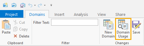
The Domain Usage pane is accessed by opening the Domains view for your geodatabase. This can be accessed using the right-click Design > Domains context menu for datasets from the Catalog pane, or from the Contents pane using layers in your map. With the Domains view open, you have a Domains tab on the ribbon. You’ll see a button labeled Domain Usage in the Changes group. Click this … and voila, the pane opens!
There are four main components that make up the Domain Usage pane:
- Workspace
- Domain
- Search
- Results grid

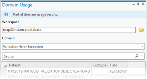
Workspace: This is the data source and geodatabase that you’ll be exploring for domain usage. This can be a file geodatabase or an enterprise geodatabase connection file. The Domain Usage pane opens with the Workspace pre-populated based on the workspace used for the Domains view. You can also swap this out to another geodatabase using the browse button next to Workspace. For enterprise geodatabases, this is handy if you want to switch over to another database connection as a different user.
Domain: This is a drop-down that is populated based on the Workspace provided in the pane. Use this to select a specific domain that you want to explore for usage in the geodatabase.
Search: Once the results grid includes datasets for the domain usage, you can search or filter the domains by using this search box. This not only filters the results by the dataset column, but also works for the subtype and field columns too.
Results grid: After a domain is selected from the Domain drop-down, the results grid is populated with datasets in the geodatabase that are using the domain.
- Dataset – table or feature class with domain assigned
- Subtype – indicates if the domain is assigned to the field for a specific subtype
- Field – the field the domain is assigned
Explore domain usage in the geodatabase
Once you’ve selected a workspace and domain using the pane, a result set of datasets is displayed in the grid. Listed datasets that are assigned directly at the field level will have the Subtype column blank, while datasets that include a value for the Subtype column have the domain assigned at the subtype level. This will determine what design view you need to open to explore the domain assignment.
Use the Fields and Subtypes design views to manage the domain assignment. Tools in the Domains toolset can also be used.

Fields view
Use this view when the domain is assigned at the field level for a dataset. The Fields view displays all fields associated with the chosen dataset. The domains associated with each field are found in the Domains column. Double-clicking the Domains column in Fields View allows you to change the domain assignment for that field or manage the domain itself. Any default value for the field is shown in the “Default” column.
Subtypes view
Use this view when the domain has been assigned to a field on the subtype level in a dataset. The Subtypes view presents all subtypes for the feature class, with each subtype shown along the top row of the table. Just below the name of the subtype, the domains and the default values for each field in the feature class are listed. Double-clicking a subtype’s active domain will allow you to change the domain assignment. The default value for a subtype can also be changed. You can create or manage subtypes from this view, using the Create/Manage option in the ribbon.
Partial results
Working with enterprise geodatabases, you may receive partial results for datasets that are using a specific domain. This will depend on the user in the workspace provided and means the user you are connected as does not have privileges to see some of the datasets the domain is assigned to. A banner will be displayed if this is the case saying, ‘Partial domain usage results.’
The geodatabase administrator can access all domain assignments in a geodatabase and should be used to view all the domain usage results. In the Domain Usage pane, simply reference a Workspace that is using the geodatabase administrator account.
Take it for a spin…
With the Domain Usage pane presenting a unified view for domain usage, you will now be able to see how domains are assigned across the datasets in your geodatabase. We hope this new pane will be very helpful to explore and manage your geodatabase domains in ArcGIS Pro. Take it for a spin and let us know what you think and share any improvements you would like to see in future releases.


Commenting is no longer enabled for this article