Data sharing promotes connectivity and collaboration among coworkers, departments, and organizations. At ArcGIS Pro 3.0 we’ve enhanced the data sharing capabilities from a mobile geodatabase to support a variety of workflows and business requirements. The ArcGIS Pro 3.0 release comes with lot of usability enhancements for mobile geodatabase users, which we covered in the Mobile Geodatabase Enhancements in ArcGIS Pro 3.0 blog article.
The goal of this blog is to talk in more depth about the different types of sharing capabilities supported from a mobile geodatabase, what data requirements you have to meet depending on the sharing option that you choose, and what type of web layers are supported.
Without further ado, let’s jump right into it!

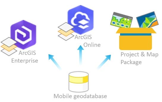
In general, when you share a web layer, a service is published and exposed through that web layer. Depending on the layer type and active portal, there are two main sharing methods supported in ArcGIS Pro; by reference and hosted. If you share your data to an ArcGIS Enterprise portal by referencing registered data, an ArcGIS Server service is published. If you share your data to ArcGIS Enterprise portal by copying all data to the hosting server, or if you share to an ArcGIS Online portal, a hosted service is published. Let’s go over these sharing methods from a mobile geodatabase perspective.
Note: To share data from a mobile geodatabase to ArcGIS Enterprise portal, you need to have a minimum version of ArcGIS Pro 3.0 and ArcGIS Enterprise 11.
Sharing a web layer that references registered data to ArcGIS Enterprise portal
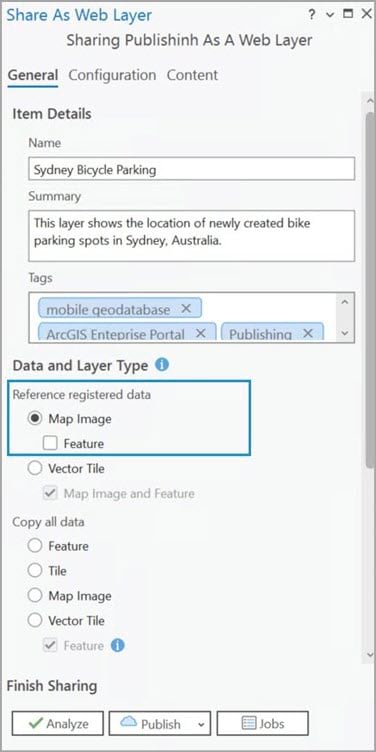
When choosing this option, the web layer will reference the data from the mobile geodatabase stored in a folder that you registered with your federated server. This sharing option allows any edits made to the mobile geodatabase data to be dynamically displayed in the resulting web layer.
Requirements to share content from ArcGIS Pro:
- Set an active connection to an ArcGIS Enterprise portal and log in to an account that is part of that organization.
- Ensure the account you are connected to has privileges to create, update, and delete content and publish server-based layers.
- Register your data source with ArcGIS Server, by placing the source mobile geodatabase in a folder and then registering that folder with the ArcGIS Server.
Types of layers that can be shared by refencing registered data:
- Map image layer—share your data from ArcGIS Pro as a map image layer to support map visualization and feature querying.
- Vector tile layer— share your data from ArcGIS Pro as a vector tile layer to support fast map visualization using a collection of pre drawn vector tiles.
Output:
- The resultant web layer will reference the data in the registered user managed data store. This means that any edits made to the mobile geodatabase will be reflected in the web layer as well.
- The resultant web layer has read-only access. This means that no edits can be made to the web layer.
Why would you share data by reference from a mobile geodatabase?
If you are working on an ongoing project where the data stored in a mobile geodatabase is dynamically changing and you want to have the most current state of the data available at the ArcGIS Enterprise organization level, you will find the option to share data by reference advantageous. Let’s look at the example below.
The city of Sydney is promoting a go green lifestyle for its residents. The DOT department is actively building new bike parking areas across the city and their sole GIS Specialist is tasked to map the newly created parking areas. Because of that, there is no need for a multiuser editing environment, so having the Bike Parking feature class stored in a mobile geodatabase fits right in. However, the GIS Specialist needs to make the data accessible to the entire DOT department for review.
In this scenario, the best option is to share data by reference. As edits are continuously made by the GIS Specialist directly to the mobile geodatabase, this sharing option will ensure the edits will immediately become available to the web layer. Because the DOT department representatives will only be reviewing and not editing the data, the resulting read-only web layer ensures that no edits can be made.

NOTE
When sharing data stored in a file geodatabase or mobile geodatabase by reference, we strongly recommend storing your file or mobile geodatabase on the local server machine.
If your business or project needs requires storing your file or mobile geodatabase on a network share, we recommend the following:
- Perform edits on a local copy of the data. Not directly to the data stored on the network share.
- Use ArcGIS Server Manager to stop the service that is exposed through the map image layer.
- Replace the file or mobile geodatabase on the network share with the local copy where edits have been made.
- Use ArcGIS Server Manager to start the service and make your edits available on the published map image layer.
By following these steps, you will improve editing performance and avoid potential data corruption in a single user editing workspace environment.
Check out this resource to learn more about the techniques and considerations for aggregating live data.
Sharing a hosted web layer to ArcGIS Enterprise or to ArcGIS Online portal
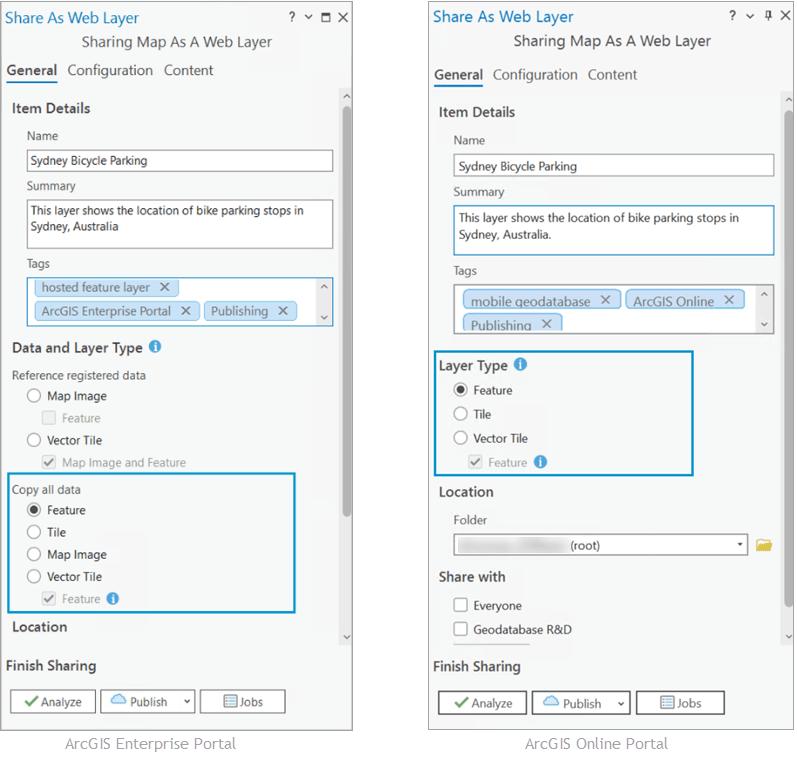
When sharing your data as a hosted web layer, you can choose between sharing to ArcGIS Enterprise or ArcGIS Online portal. If you choose to share data from a mobile geodatabase to ArcGIS Enterprise, but you don’t want the layer to reference your source data, then you will go with the Copy all data sharing option. Your data will be copied to the server and the resulting hosted web layer with become a standalone copy of the original data.
If your organization doesn’t have its own ArcGIS Server site (ArcGIS Enterprise portal), then you can choose to host your mobile geodatabase data in an ArcGIS Online portal, by sharing it as a hosted web layer.
Requirements to share content from ArcGIS Pro:
- Set active connection to an ArcGIS Enterprise portal or ArcGIS Online Portal
- Privileges to publish hosted feature layers.
- If sharing data to ArcGIS Online, choose the appropriate layer type.
Types of layers that can be shared by copying all data to ArcGIS Enterprise or ArcGIS Online:
- Web feature layer— share your data as a feature layer to support feature querying, visualization, and editing. In this case the feature layer cannot be shared as a standalone web layer.
- Web tile layer— share your data as a web tile layer to support fast map visualization using a collection of pre drawn map images or tiles. These types of web layers are appropriate for basemaps.
- Vector tile layer— share your data from ArcGIS Pro as a vector tile layer to support fast map visualization using a collection of pre drawn vector tiles.
- Web scene layer— share your data as a web scene layer to support querying and visualization of point, 3D objects, building, point cloud, integrated mesh, and voxel data.
- Map image layer— share your data from ArcGIS Pro as a map image layer to support map visualization and feature querying. *Map image layers can only be shared to ArcGIS Enterprise.
Output:
- The resultant web layer will be a hosted web layer that represents an editable copy of the data stored in the mobile geodatabase. This means edits can be applied directly to the hosted web layer.
- However, it is important to remember that the edits made live only in the hosted web layer and cannot be synced back to the source data.
Note: If syncing capabilities or multiuser editing are needed you will have to migrate your underlying data from a mobile geodatabase to an enterprise geodatabase and enable versioning capabilities.
Why would you share data as a hosted web layer from a mobile geodatabase?
Continuing the above scenario, the DOT department has reached its goal and completed the mission to build bike parking areas in Sydney. Because of its success, the Parks & Recreation group wants to continue the work by adding scooter rental areas alongside the bike parking ones.
As sharing a web layer by reference allows for read access only, the DOT GIS Specialist will share the bike parking feature class stored in the mobile geodatabase, as a hosted feature layer with editing capabilities enabled. Because the DOT department has its own ArcGIS Enterprise portal and the Parks & Recreation group is part of the department, the GIS Specialist can share the bike parking data as a hosted feature layer. This will ensure the Parks & Recreation group can edit the hosted feature layer and add the scooter rental areas.

Sharing as package
A package is a compressed file containing GIS data. You share a package in the same way as any other file – via email, FTP (File Transfer Protocol), the cloud, thumb drives, and so on. You can share it between colleagues in a workgroup, between departments in an organization, or with other users via ArcGIS Enterprise or ArcGIS Online.
Prior to this release, when sharing data stored in a mobile geodatabase as a project package or map package, the resultant package converts the mobile geodatabase to a file geodatabase format.
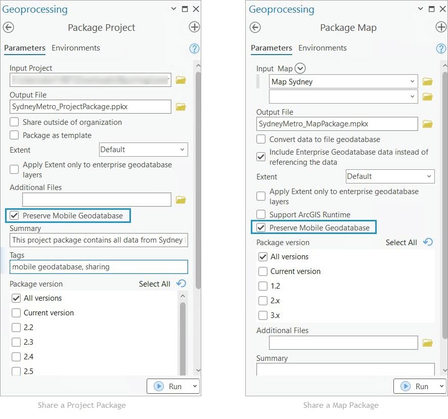
With the ArcGIS Pro 3.0 release, we’ve added the capability to preserve the mobile geodatabase format when sharing as a project package or map package from ArcGIS Pro.
Note: Currently, the option to Preserve mobile geodatabase is available only to the Package Project and Package Map geoprocessing tools.
Output:
- A project package (.ppkx) that saves and shares the project along with its maps, data stored in a mobile geodatabase, styles, toolboxes, tasks, attachments, geoprocessing history, and connections.
- A map package (.mpkx) that contains a map document (.mapx) and all the data referenced by the layers in it. Essentially, the resultant map package is a collection of layer packages along with the map document.
Why would you share data as a package from a mobile geodatabase?
The GIS Specialist working for the DOT department has received an inquiry via email from a contractor working for the City of Sydney. The contractor is interested in finding out what bike parking areas are located within 2 blocks of the stadium, pubs, and other recreation areas. They have requested access to the original data together with the results of the geospatial analysis.
After adding the recreational locations and performing a select by location analysis, the GIS Specialist stored the results in a different map within the same Pro project and shared it as a project package with the save to file option checked. Then added it as an attachment in his email to the contractor.
By choosing to share the bike data and the analysis as a project package, the GIS Specialist was able to include the complete project along with the maps, the reference data, and the folder connections. Because the contractor is not a member of the DOT department, the GIS Specialist was able to share the resultant file as an attachment file via email.

With each software release we are enhancing the mobile geodatabase to better support workflows that help you achieve your business goals. We hope you find these types of usability enhancements useful, and we look forward to seeing how you include them in your workflows.
Photo by Brett Jordan on Unsplash

Commenting is not enabled for this article.