The Resource Management solution is now available to deploy with ArcGIS.
The first release of Resource Management includes a collection of maps and apps which serve as a set of tools to help the National Guard and other military organizations.
The solution equips a military command with a fast and efficient method to collect equipment inventories from subordinate units.
With this solution you can do the following:
- Streamline asset inventory collection
- Extract rich and useful information related to unit’s arsenal
- Edit, append or delete equipment inventories
- Implement a simple data upload process for immediate analysis
- Filter and extract specific asset details
- Make informed resource allocation decisions
- Configure solution in minutes
- And much more…
Click image below to begin interacting with the Resource Management Dashboard.
Resource Management Dashboard
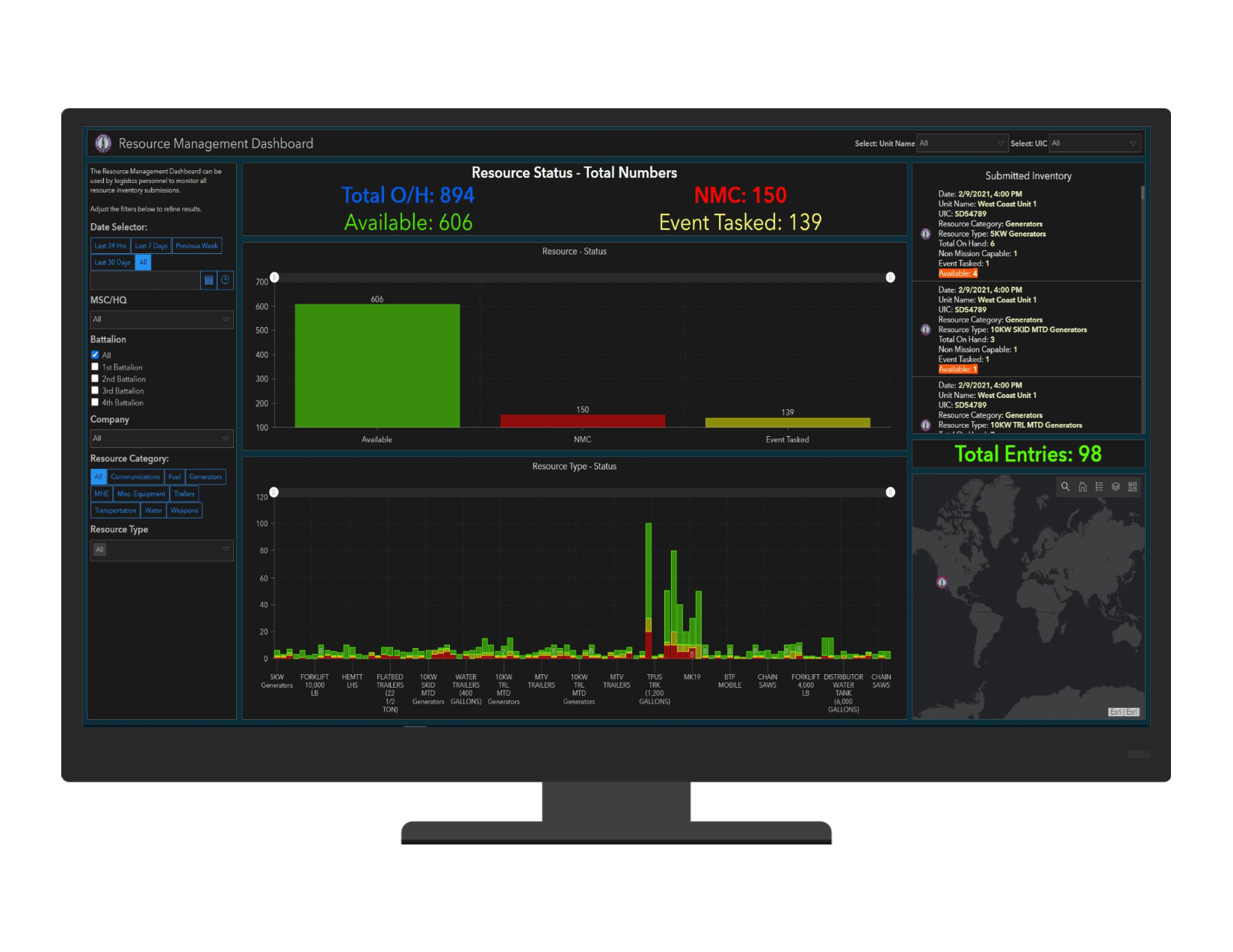
Collect and Monitor Critical Asset Information
The Resource Management solution leverages unique ArcGIS Online features along with Dashboards to provide a dynamic approach to equipment inventory collections.
It is a difficult task for military organizations to track equipment location, ownership and operational status. It’s a common practice to share resources among units within a larger command. The National Guard is one of the most involved organizations in the country. They consistently respond to a variety of events that require a multitude of resources and equipment to successfully complete resulting missions.
Units deploying Resource Management are normally searching for a way to maximize their efficiency and take a data-driven approach to asset management. The solution quickly organizes all collected data into various asset categories and types. Logistics personnel and leadership are able to select and filter equipment information based on a variety of options.
The solution enables a military organization to quickly upload their installations and resource inventory data. Immediately after datasets have been uploaded, the solution will execute a join function and combine the two files. Resource Management will rapidly begin to organize it all into a modern and interactive user interface.
Click on the image below to watch a step-by-step video on how to upload your data.
From Spreadsheet to Interactive Interface

Know Your Equipment’s Location and Operational Status
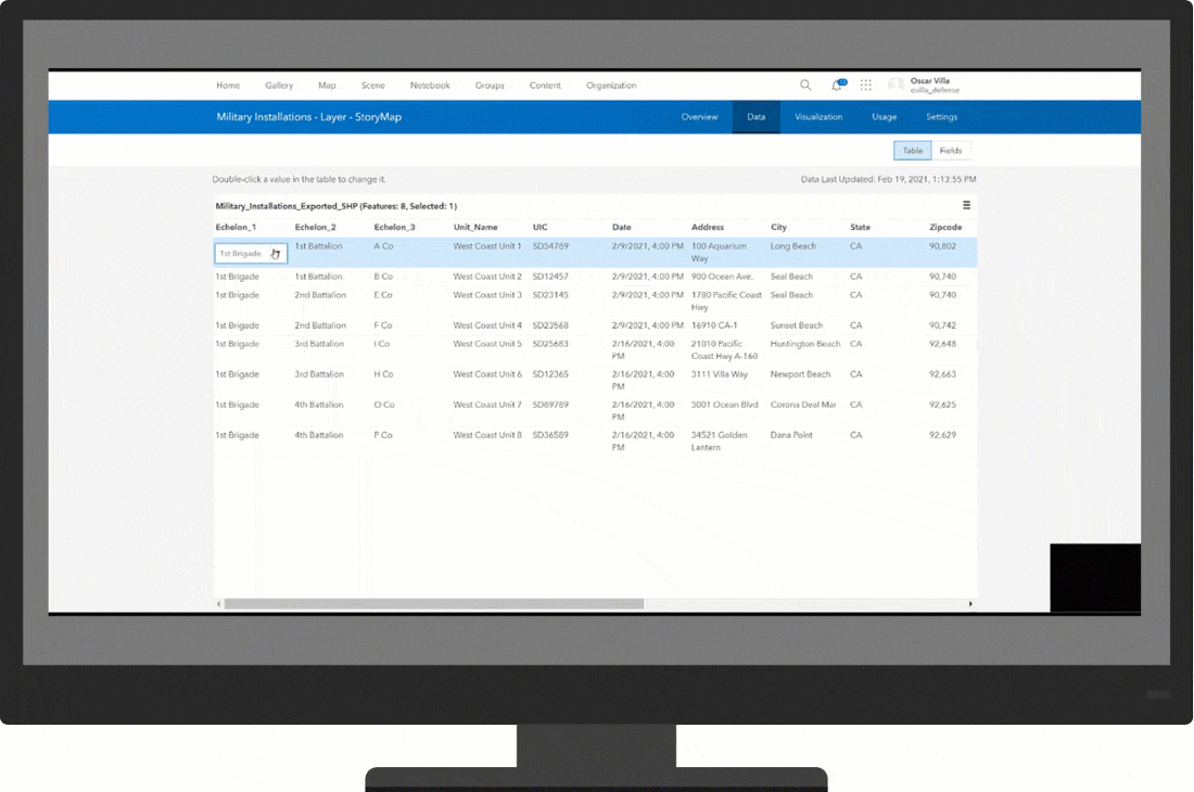
The Resource Management solution empowers organizations to capture critical asset information from the lowest to highest levels of command.
The solution deploys with two spreadsheets: military installations and resource inventories. All units within a command or region reporting to a headquarters or command center will use these files to submit their equipment inventories. The datasets collect important information such as: installation name, address or lat/long, equipment category, date, etc.
Resource Management was mainly designed to be submitted by logistics personnel at each subordinate unit. All collected information will easily be aggregated by the solution where supporting staff and leadership can review and analyze.
The inventory data is displayed by total installation entries and total equipment count. Four resource statuses are tracked: Total On-Hand, Available, Non-Mission Capable, and Event Tasked. The embedded map will show the exact unit location and associated equipment that was submitted.
This immediate interaction between the included forms and Web Apps allows for rapid dissemination and intelligent decision making. The solution gives the organization the freedom to isolate a specific unit, date, asset category or type and find crucial information within seconds.
Finally, Resource Management deploys preloaded with a comprehensive list of domains to support a general command structure. The solution also comes with a multitude of asset categories and equipment types. Some military organizations will continue to use the included lists while others will find it easier to modify the embedded options to compliment their workflows.
Click image below to watch a short video displaying all embedded domains.
Embedded Domains
I’m excited to share this new solution and its capabilities with you. Please reach out and let us know if you have any questions about this solution. Be sure to provide us with your feedback on GeoNet.
Wait!
Before we go our separate ways, let me give you three tips on how to get started.
Easy to Deploy
Deploying this solution is extremely easy by simply using the ArcGIS Solution App.
Easy to Configure
Resource Management is ready to use immediately after deployment, but you may need to do small changes to reflect a naming convention applicable to your organization. Check out our documentation to learn how.
Easy to Use
As easy as it is to deploy to your own ArcGIS Online, you can first test the solution here, via our Try-it-Live site.
Additional Resources
Learn more about the Resource Management solution and how you can quickly deploy the solution from the ArcGIS Solution site.

Article Discussion: