The Mission
GOHUNT launched their mapping program for the modern hunter in early 2020. One of their earliest strategic decisions was selecting the right technology partner. They were looking for four things in a strategic, long-term partner:
- Platform compatibility with their business model
- Deployment speed
- Partnership and developer support
- Interoperability with both their existing systems and future GIS data and engineering needs.
Just two years after selecting Esri technology, GOHUNT are competing in a new marketplace bringing more options to consumers and driving cutting edge innovation across the hunting industry.

Support and implementation
As a newcomer to the Esri suite of tools, GOHUNT found themselves needing guidance on the technologies available to them:
“One of the more daunting aspects of getting started with Esri is the vast array of systems, programs, and resources available. Early on we struggled with understanding how to properly leverage all capabilities and align them with our immediate needs.” Mike Dietrich, Product Manager of GOHUNT explains.
Esri’s Professional Services team provided the design and support expertise that GOHUNT needed by establishing direct points of contact between GOHUNT developers and Esri team members. “The Professional Services Team would tap into the wealth of knowledge at Esri and surface subject matter experts who would help remove barriers, offer advice and recommendations, and point us towards the resources and documentation we needed to overcome each challenge.” Dietrich recalls, “This engagement was essential for us and is recommended for all who are considering building on ArcGIS Platform and the Runtime SDK.”
Product Flexibility
ArcGIS Platform (PaaS) product offers an unparalleled level of flexibility that is well suited to businesses that may experience demand fluctuations. The product offers a usage-based, pay-as-you-go model for all location services, including the basemap layer service that contains satellite imagery, topographic, and outdoors basemaps. For GOHUNT, a usage-based model is the best approach for their app, as it offers a lower barrier to entry for large technical projects.
The hunting industry is seasonal, with demand spiking in the fall and spring and dropping dramatically in late-winter and early-summer. This natural ebb and flow required a service infrastructure that is flexible enough to ensure the cost of services remains competitive year-round for GOHUNT’s end user. ArcGIS Platform suits their needs perfectly. It allows clients access to on-demand raster and vector datasets, elevation, and location services that scale dynamically with user demand. Using ArcGIS Platform as the foundation, GOHUNT is able to focus on growing its user base exponentially without worrying about service reliability.
Powerful Native Applications
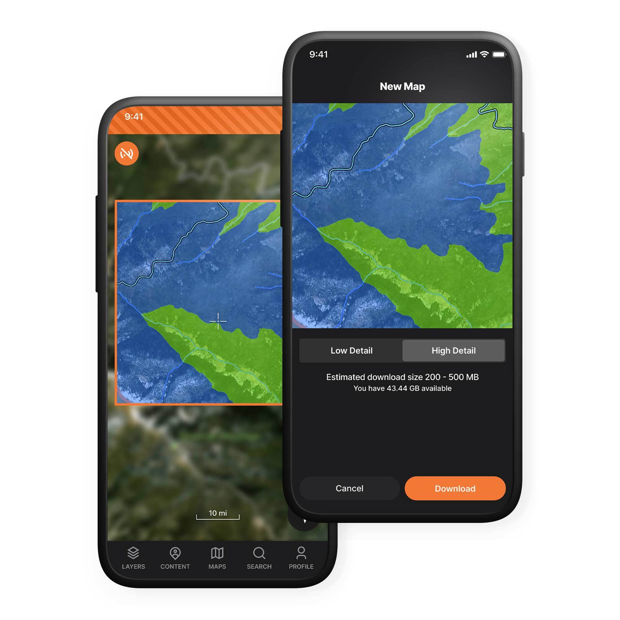
GOHUNT established requirements for their go-to-market strategy that demanded a full-featured SDK for building stand-alone, custom mapping applications across iOS, Android, and desktop. Their core requirements were 3D mapping, vector and raster data consumption and rendering, data access in connected and disconnected environments, and developer-friendly technical documentation to reduce implementation time. ArcGIS Runtime SDKs met all the prerequisites by enabling rapid deployment of powerful, lightweight GIS applications that are compatible with the broader ArcGIS system.
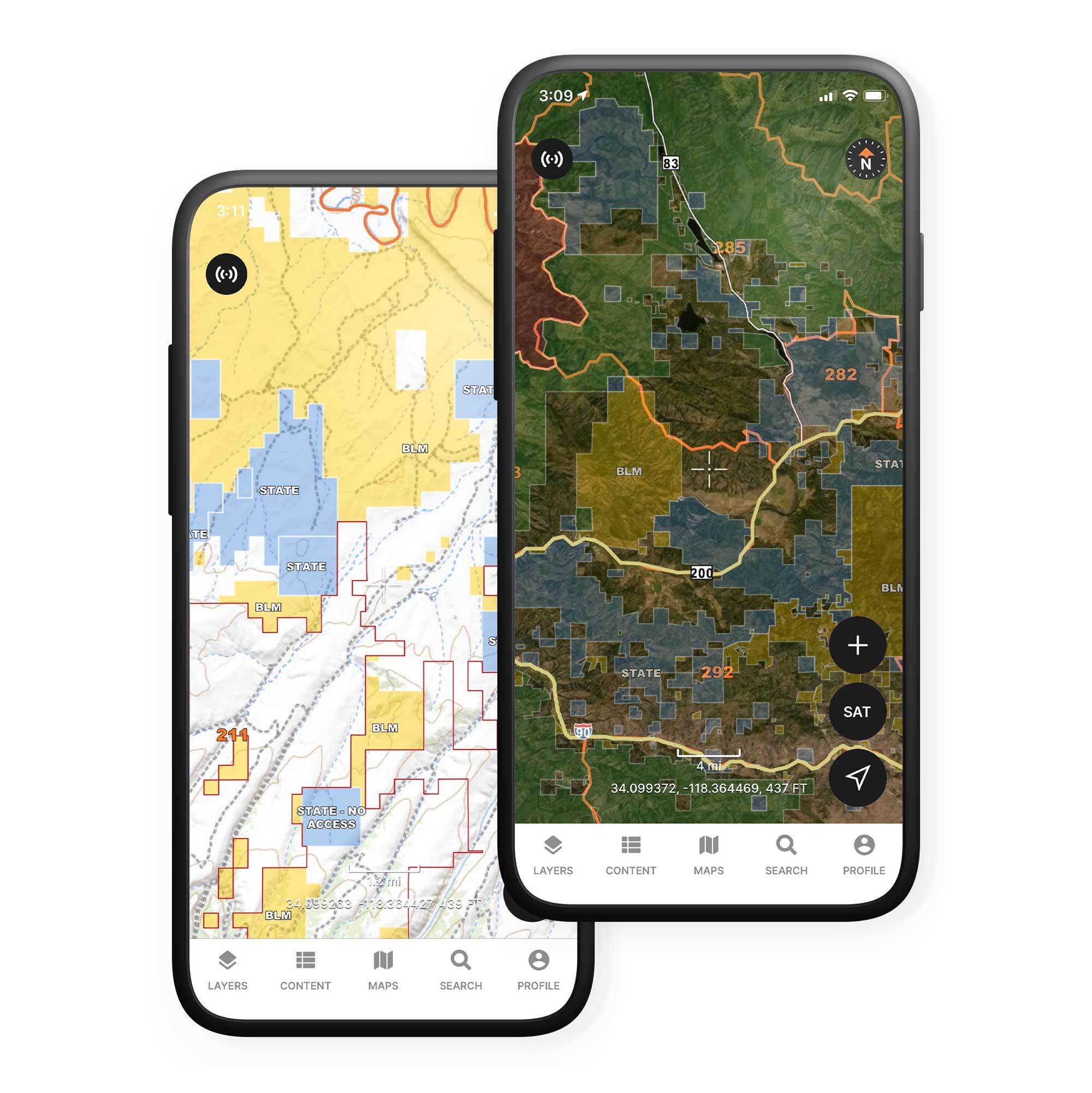
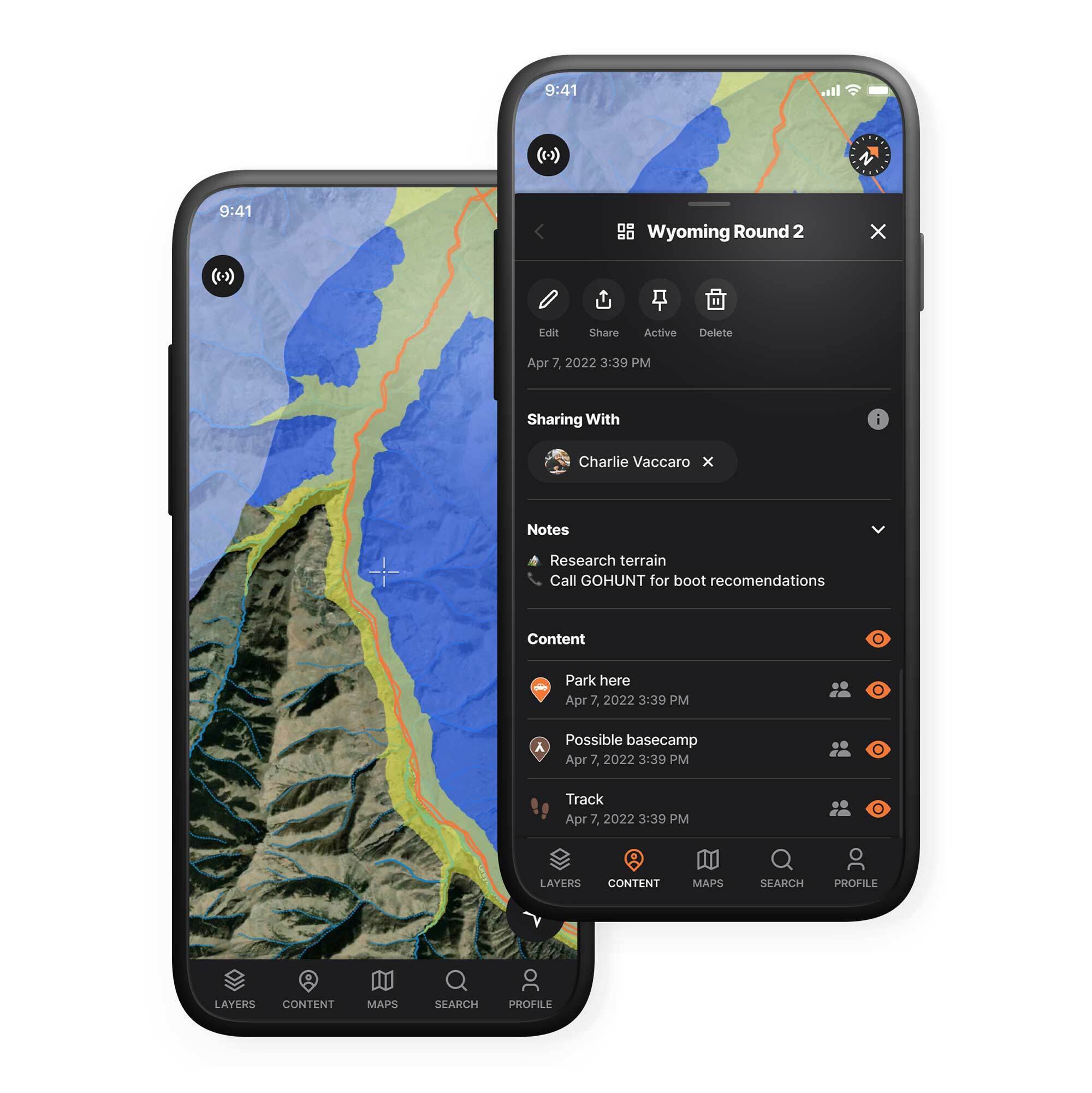
With ArcGIS Runtime SDKs, GOHUNT was able to quickly deploy an elevation layer for 3D scenes, drape a base map layer for imagery and contour mapping, and render combinations of point and line graphics in their apps. Specifically, the Java Script API allowed for 2D and 3D visualization as well as client-side analysis of terrain and environmental conditions while the Runtime SDK enabled offline 3D visualization. With these capabilities available, they stood up a larger GIS infrastructure, leveraging ArcGIS Enterprise, to internally process and distribute large amounts of user-generated and custom vector content for their end users to consume across their entire platform.
Mapping engines are complex. The Runtime SDK does the heavy lifting and allows the GOHUNT team to focus on building the custom functionality that their users need and most appreciate in the field. Dietrich explains, “This is a massive competitive advantage for us. We were able to deploy a feature-rich, fully functional, custom 3D mapping and navigation platform with a small team in under 18 months. By building on top of the Runtime SDK, we are now competing head-to-head with entrenched competition with a five plus year head start in the space.”
Interoperability
One of the core benefits of building with Esri is the interoperability of the ArcGIS system. GOHUNT has leveraged ArcGIS Platform, ArcGIS Runtime, ArcGIS Pro, ArcGIS JavaScript API and ArcGIS Enterprise to build and deploy custom mapping applications across desktop, iOS, and Android. They are able to tap into additional content resources from the Living Atlas and effectively manage ArcGIS Enterprise and ArcGIS Developer licensing and accounts. They can rely on the world-class product and engineering teams at Esri to offer trusted advice and recommendations every step of the way. Dietrich believes, “Our success would not have been possible without the innate synergies of all these systems and services.”
A Hunting Company
GOHUNT is a hunting company with a focus on conservation and making it easier for sportsmen to get into the field and conduct hunting activities. Leveraging the latest ArcGIS APIs, location services, and tools, they are reducing barriers for new hunters and helping everyone better connect with the primal world.apl
GOHUNT recently announced the public launch of Explorer – one of the most competitive digital mapping memberships on the market today. Explorer offers a seamless, synchronous web and mobile mapping experience, geared towards the hunting community. Esri and GOHUNT will be collaborating on a 2-3 part series of Customer Success Stories to showcase the implementation of ArcGIS Pro, Enterprise and JavaScript API.


Article Discussion: