Each year, humanity faces countless natural disasters, with tropical storms or hurricanes being a familiar threat to many in the United States. The American Southeast, in particular, faces intense flooding, powerful winds, and heavy rainfall. In 2023, we saw 840,000 individuals displaced in Florida.
Most recently, Hurricane Helene took an unexpected turn through Western and North-Western North Carolina. While recovery is still underway, this has already been one of the most destructive storms in the United States. Historically, this region has been untouched by hurricanes due to its far inland location and mountainous terrain. The region’s infrastructure was not constructed with hurricane-force winds or flooding in mind, which led to destruction of the area beyond anyone’s expectations. Due to the immense damage caused by the storm, numerous people were left missing or without homes, power, food, or cellular signals. In this blog post, we’ll discuss an example of how Esri’s software can be used for response to a natural disaster, specifically through damage assessments. Damage assessments using imagery help identify areas that require emergency response and play an integral role in creating response plans. Assessing damage remotely in advance can also potentially reduce risk to the response team.
The Methods
The primary goal of this research was to perform a damage assessment using ArcGIS Video Server and ArcGIS Excalibur. To accomplish this, we used livestream footage from the affected region, along with aerial imagery captured before and after the storm.
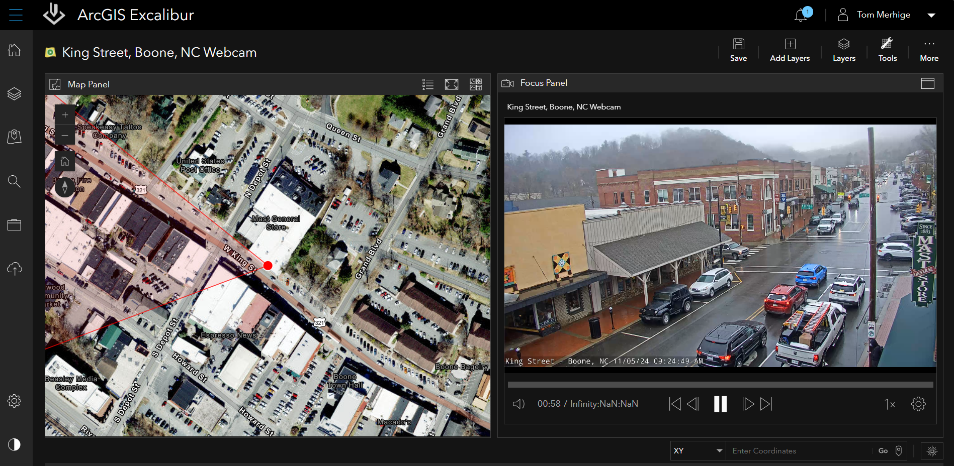
Initially, our team published video services through ArcGIS Excalibur’s publishing workflow, enabled by ArcGIS Video Server. ArcGIS Video Server preserves any spatial metadata our videos contain, retaining that information and using it to map out the location of sensors, cameras, and other devices. As a result, we carefully determined where damage and potential emergency situations had arisen by comparing the sensor locations to the video in question. We also created a livestream service for the purpose of allowing us to monitor the ongoing situation on the ground and maintain a level of awareness regarding the status of the downtown Boone, NC area.
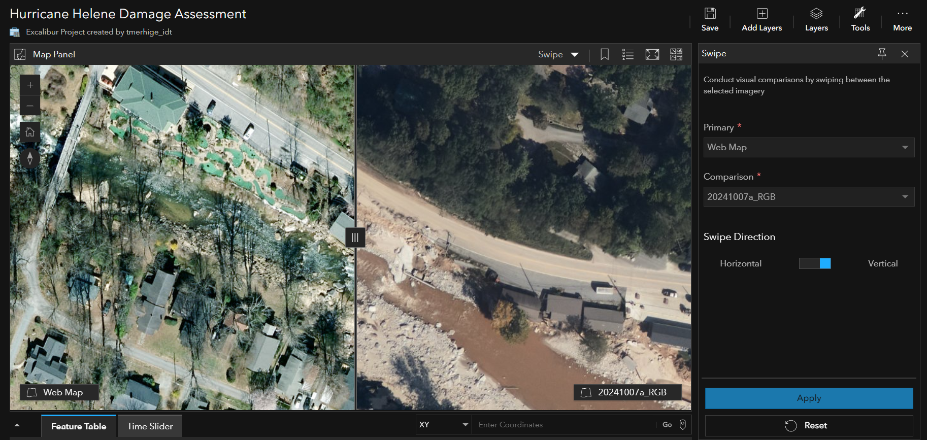
Our next goal was to utilize ArcGIS Excalibur for the damage assessment. Excalibur can be used with imagery, video, or live stream services to identify points of interest such as potential roadblocks, locations where people may still be trapped, and critical infrastructure. At this point, we loaded imagery of the region and began our analysis of the data.
By comparing imagery taken prior to the storms with that taken immediately after, we were able to quickly assess the extent of damage in Western North Carolina. We observed that numerous roads were washed out, areas of blowdown were common in the forested areas, and entire homes were destroyed during this tragically historic event.
ArcGIS Excalibur as a Web Application for Analysis
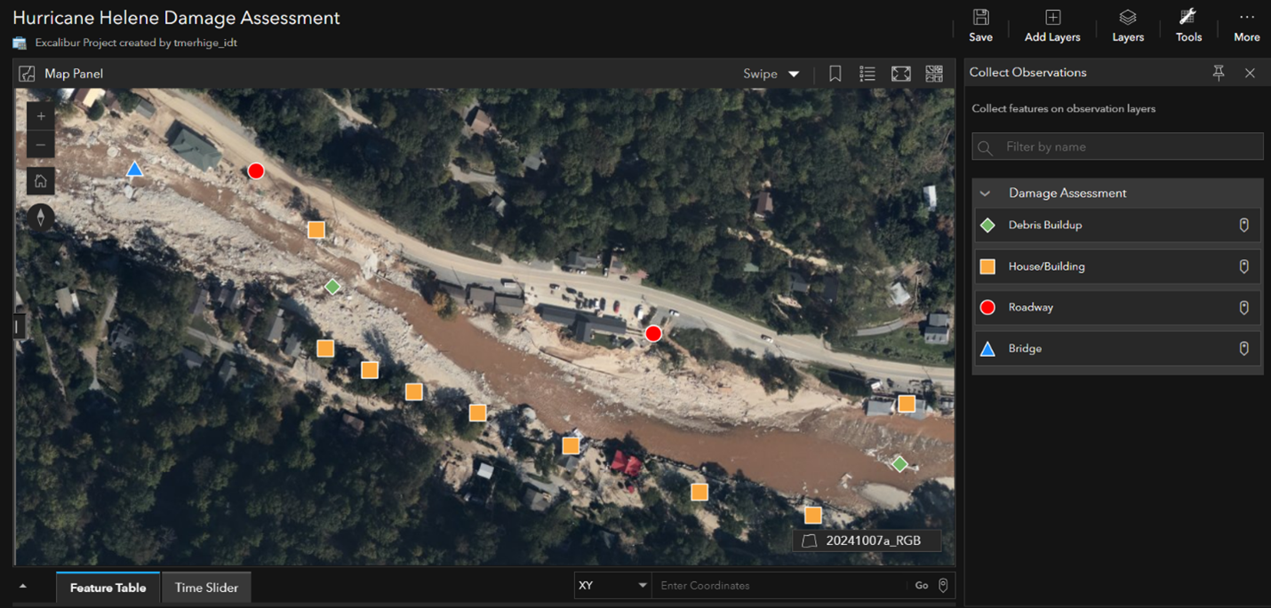
One of the most crucial issues we needed to monitor was the collapse of roadways. These roads were necessary for delivering supplies, bringing in aid workers, and ensuring infrastructure could be rebuilt in a timely manner. We noted several locations which were in particularly bad states, requiring workers to repair them so that others could get into the region with additional aid.
These damaged areas were then analyzed to determine next steps. Using the Observation Tools in ArcGIS Excalibur, we identified points of interest. Mud slides and flooding had destroyed roads, which would require a team to clean and rebuild where possible. A number of low-lying homes had severely flooded, with the torrent of water from the hurricane having washed away entire buildings. Additionally, roadways, bridges, and buildup of debris were found which all pose serious issues when it came to evacuation, rescue, and repair operations.
After collecting observations, we were able to use Excalibur’s Chip Observations tool to create image chips around the identified areas. These image chips can then be imported into a Web Map or Attachment Viewer application to provide greater levels of detail when rescue or rebuilding efforts are underway. Using the imagery in ArcGIS Excalibur, we were able to mark passable routes throughout the city that lead to newly established shelters. With many roads left destroyed, these were seemingly safe paths where victims of this disaster could safely reach on foot.
Another concern during this period was that additional storms could lead to further flooding and damage. Using the video services we had created previously from livestreams around Western North Carolina, we were able to continuously monitor the status of the area over the course of the storm and point out locations that may need urgent attention. Additionally, the live stream provided a real-time portrayal of the severity of flooding in specific locations, as well as which areas were less impacted. Thanks to ArcGIS Video Server’s ability to utilize spatial metadata, we could instantly target and map specific points of interest within our field of view to investigate further.
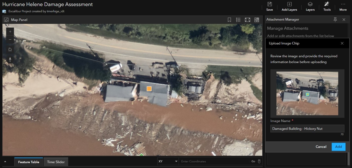
As a part of this effort, we generated an interactive Attachment Viewer application containing the image chips as attachments. This application outlines our damage assessment findings in an easily digestible format, which can be used by other teams to strengthen their efforts. For example, a response team may utilize this assessment while conducting field repairs to target heavily impacted areas. The application uses a basemap created pre-flooding, while our post-flooding imagery can be seen as attachments. This allows for a quick and clear assessment of how severely each point of interest was damaged during the storm.

Tying It All Together
Our damage assessment, utilizing ArcGIS Video Server and ArcGIS Excalibur, was ultimately successful in determining major points of interest across Western North Carolina that needed rescue and repair. This data could have then been passed along to teams on the ground or in supervisory positions to make informed decisions regarding recovery efforts. Moving forward, ongoing efforts could utilize other Esri software such as ArcGIS Mission to manage workers’ tasks, or ArcGIS Story Maps to create informative outputs. These could include detailed descriptions of the repair effort and how heavily damaged the region has been. This damage assessment not only shows the beginning of what could be accomplished over an extended period with sufficient data, but also the benefits of utilizing ArcGIS Video Server and ArcGIS Excalibur together.


Article Discussion: