Version 1.4 of ArcGIS Maps SDK for Unreal Engine continues our dual-purpose mission to bring accurate real-world geospatial data to Unreal Engine and to integrate GIS capabilities seamlessly with your game engine app development. Highlights in this release include filtering of building scene layers by category, discipline, or SQL expression, as well as the ability to replace areas of terrain with a constant elevation value. In addition, previously released support for scene layer filtering and mesh modifications is now available on mobile platforms, and all these capabilities are made available both via the API and through a low-code/no-code experience within the Unreal Engine editor.
Building scene layer filtering
Building scene layers enable you to view one or more building models together in their spatial context and to work with the component parts of these buildings by querying and filtering different aspects. The ability to visualize building scene layers was already available in a previous release, but these layers are both visually complex and contain highly detailed representation of real-world structures. With the incredible level of detail a building scene layer may include, you often to want to interactively filter elements or parts of a building to see only the information that is important and necessary for them to complete their work. For example, you may want to see only the parts of a building that are on the second floor, show only the load-bearing walls, or just the electrical system. As a developer using either the low-code/no-code tools, scripting with Blueprints, or programming with the API, you can support these user requirements by applying a filter to a building scene layer. Filters give you access to the full structure of a building scene layer including the discipline, such as architectural, the categories, such as walls, and custom queries to filter elements based on their attribute values such as the material type or manufacturer.
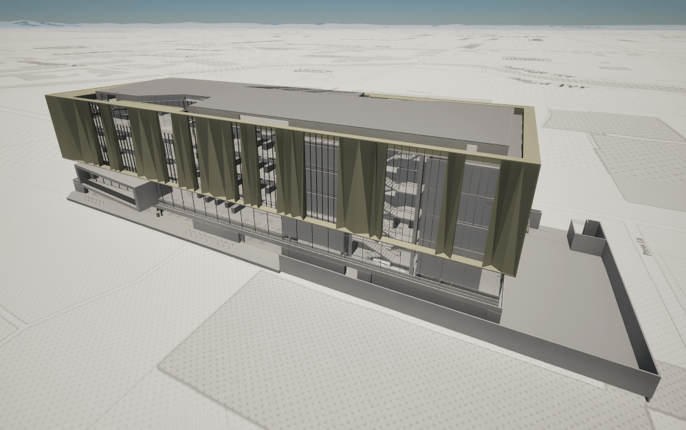
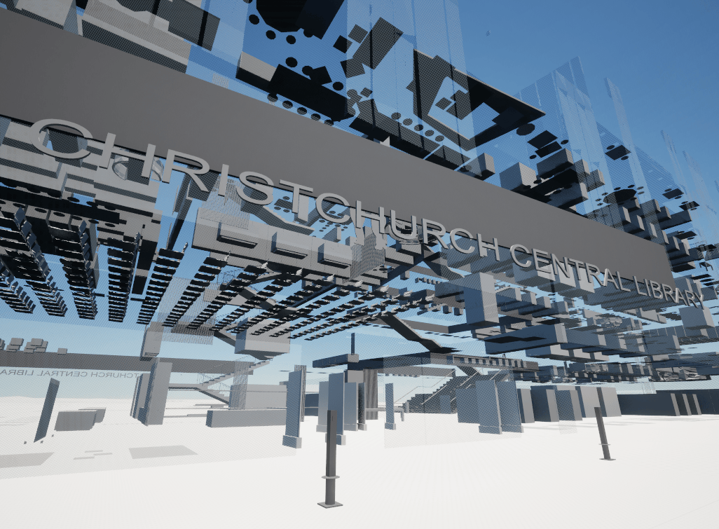
Opened in October 2018 and covering approximately 10,000 square meters over 5 floors, the Turanga Central Library in Christchurch, New Zealand is a good example of a complex, modern structure digitally designed and recorded in great detail. It has been published as a building scene layer, derived from an original Revit Model by Christchurch City Council, enabling us to use the new tools in the latest release of the Maps SDK for Unreal Engine to explore the building. For example, by filtering out the primary aspects within the architectural discipline such as the walls, floors, ceiling, and roofs we can show all the interior aspects and various adornments.
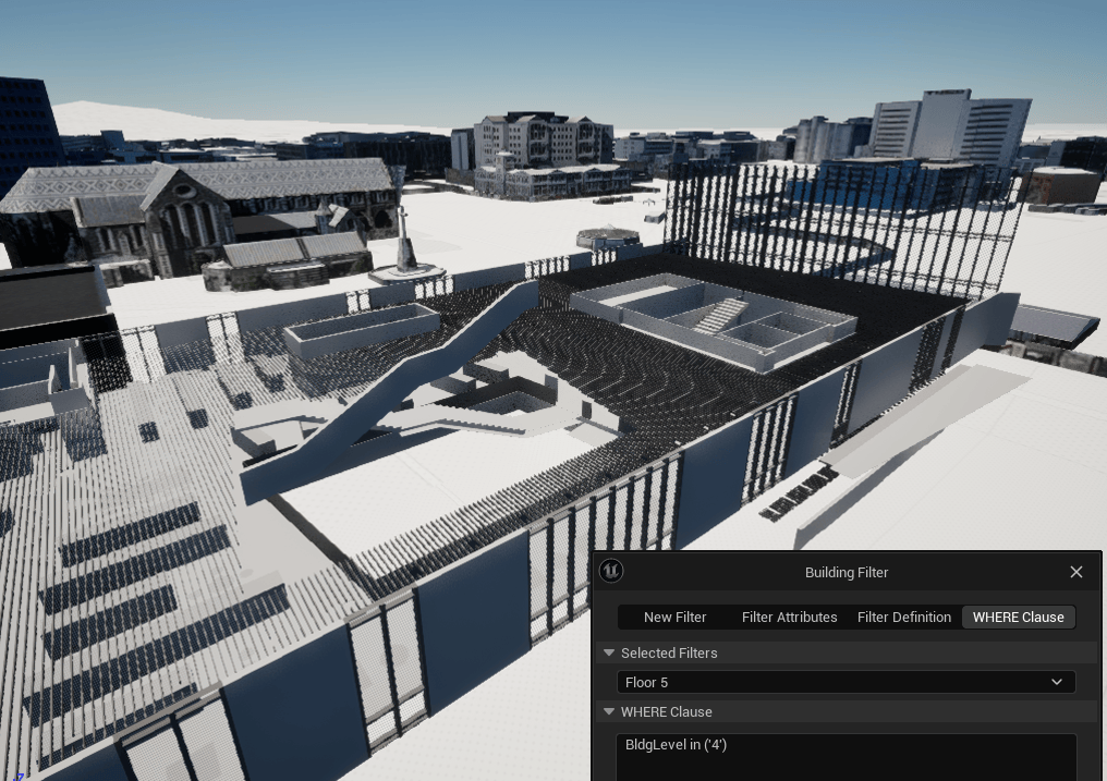
In addition to filtering by discipline and category, these new UI tools enable you to create custom filters based on SQL expressions. Here we’ve used this capability to filter the entire building by the building level and show just the content for a single floor.
Spatial filtering and mesh modification
The ability to spatially filter scene layers and modify meshes was already available in a previous release, but only when using the API, and only on the supported desktop platforms (macOS and Windows). With this release, this powerful capability can now be accessed through a new UI in the Unreal Engine editor as part of our ever-increasing support for no-code/low-code workflows. The UI tools enable you to interactively draw and modify polygon areas to be applied as spatial filters for 3D object scene layers and building scene layers, and applied as mesh modifications for integrated mesh scene layers and terrain datasets. This feature can now also be included in applications deployed on the mobile platforms Android and iOS.
Another valuable addition for mesh modifications is the new ability to simply apply a constant elevation value to the polygon areas you have defined, avoiding the need to replace with another existing terrain dataset. A corresponding new modification type replace has been added, enabling you to apply a new constant value to the specified area and specify a new altitude.
Virtual tabletop
This release now provides greater support in Unreal Engine for building virtual tabletop experiences that enable users to visualize and interact with real-world geographic data in a scene placed on a surface within their virtual or physical environment. In most cases these immersive experiences are enabled through the use of extended reality (XR) headsets. These experiences are notably popular in the AEC, defense, and public safety sectors for collaborative planning scenarios where users can view, interact, and coordinate around a common, immersive digital operating picture and make informed decisions without the need to be in the same physical space.
The SDK includes a new tabletop sample that contains an ArcGIS Tabletop Controller component that works with the ArcGIS Map and ArcGIS Camera components to determine the geospatial content to render plus a center location in real-world coordinates and a radius in real-world units to determine where and how far to clip the map. The sample also includes a new ArcGIS Tabletop Player Controller component that supports user navigation with the virtual tabletop.
Download and get started
To get the latest version, go to the ArcGIS Developers site, sign in, and download ArcGIS Maps SDK for Unreal Engine. See the Release Notes for more details about enhancements, deprecations, resolved issues, and known issues in this release. If you’re new to developing with our SDK, simply sign up for a free ArcGIS Developer account then go to the Get Started page in the Guide doc.


Article Discussion: