by Ernest To1*, Carissa Belsky3, David Harkins1, Jim Patek2, Steve Stecher3, Mel Vargas2, Jennifer Walker4
1RPS Espey
2Parsons Corporation
3Crespo Consulting Services, Inc.
4Watearth, Inc.
*corresponding author
 From 2011 to 2012, the Texas Water Development Board funded a study (TWDB Contract#:1004821120) to evaluate sedimentation risks for 194 major reservoirs in the state of Texas (see the previous Hydro Blog). The ultimate goal of the study was to support watershed protection planning to protect water quality and water availability in Texas reservoirs.
The associated GIS data and map products from this statewide study are now available to the GIS community, and can be downloaded here.
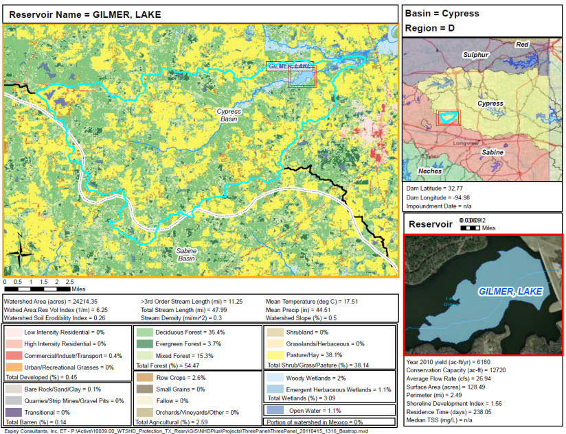
The GIS data are provided in an ArcGIS Map Package. This package contains GIS layers related to the watersheds of Texas reservoirs. These include watershed landuse, landcover, soil erodibility, stream hydrography; and descriptive reservoir statistics (e.g. conservation capacity, yield, residence time, etc). Sources of the information include the National Hydrography Dataset (NHDPlus), United States Geological Survey (USGS), Texas Water Development Board (TWDB) and the Texas Commission for Environmental Quality (TCEQ).
The Map Package also contains an ArcMap project that was used to generate a series of maps in pdf format that displayed sedimentation-related information for each major Texas reservoir. The reservoir maps are organized by Texas river basin (e.g. Colorado, Guadalupe, Red River) and are sequenced from most upstream to downstream. The maps are available here.
The associated report from this study can be found on the TWDB website at: http://www.twdb.state.tx.us/publications/reports/contracted_reports/doc/1004821120_reservoirs.pdf.

Wow, this might be my favorite ArcGIS Online addition yet! That opens up so many new options for making a good looking map. Surprised to see it in ArcGIS Online before ArcGIS Pro.
so nice to see. I still struggle to bring this blended map into an app. No way of seeing the shaded relief. Any thoughts?
Hi Marco – Does the blending on the web map look fine when viewed in the Map Viewer Beta, but doesn’t look ok in the other app? It could be they’re not yet using the latest 4.x JS API to power that app, so it might just be time before it catches up. For example, if you open a web map with blending in the classic Map Viewer it won’t show the blending.
Wow! Anyone know when it will be available on ArcGIS Pro?
Simon, good news! They’re coming soon to Pro. They’re listed as “near term” here on their roadmap https://community.esri.com/docs/DOC-15230-arcgis-pro-roadmap-july-2020