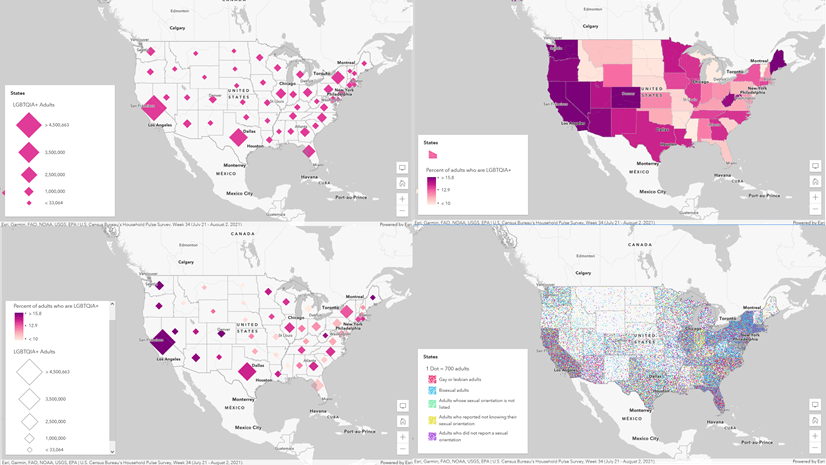
One of the great joys of working here at Esri is the opportunity to collaborate with amazing people. Recently I had the opportunity to present at the User Conference about thematic mapping, with Sarah Bell and Kenneth Field. It was a lot of fun and we all surprised each other with what we made from the same source data. One of the most beautiful aspects of cartography is there is no one right way to make a map. Here is what I made with some election data that Ken supplied us with.

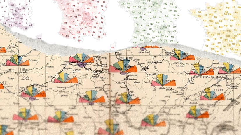
The title of this blog post says “How to” but actually it’s more like why to make this map the way that it is. There’s a lot to consider when making a thematic map, particularly election maps. This takes a pretty narrow look and mercifully uses data from Great Britain, which it turns out is not my home country. This was a nice change. Fresh eyes.
Here’s the video…
0:00 Rootin tootin introduction
0:32 Compared to what?
1:02 Explore the data
1:25 We ask too much of one map
1:47 Reveal information progressively
2:11 Sneaky legends
2:27 Complexity requires an investment
If you’d like to dive deep into all manner of thematic mapping techniques (it’s an endless path, my friends) I encourage you to check out Ken’s book on the subject.
Thanks for watching, and happy thematic mapping! Love, John


Hi Aziza, thanks for the article, this is great functionality and I’ve learned today that you can create a print service from ArcGIS Pro. However, as you will not be surprised to see someone ask, are there any plans to allow us to host custom print services in ArcGIS Online? We can potentially get access to Enterprise but in conversations with our Esri account managers they’ve generally tried to steer us away from this and suggest the use of AGOL instead. So when we see functionality like this that isn’t available in AGOL it’s a bit frustrating. Any updates would… Read more »
Hi Anthony, I am not sure when this feature will make it to ArcGIS Online. I know that the team is working on it but haven’t heard any release date yet. For ArcGIS Online, you can check out the Feature Report widget in Experience Builder after June release (end of June 2024), you will be able to upload your report template as docx file to create PDF report. it uses ArcGIS Survey 123 reporting service to generate reports. Current limitation of this widget is, the data source needs to be feature layer that is associated with ArcGIS Survey123 survey but… Read more »
Hi Aziza,
Any news about reports in Near Me in ArcGIS Enterprise? Or a Feature Report widget for regular Feature Services? Or any upcoming support for Map Services in both? We really need reporting capabilities built-in in ExB for ArcGIS Enterprise.
Hi Patrice,
Yes Near Me is in Enterprise 11.3 now. No progress on feature report using regular feature service.
We are working on a client side reporting for Near Me which should be available soon 2025 Q1/ Q2.
Aziza,
Thanks for the great article! What would be the workflow if we only wanted a report with no maps? That’s actually a more common request at our organization, and I’d love to set a lot of those up for self-service.
Hi Jay, In the EXB Print widget configuration, from the Layout dropdown, choose ‘MAP_ONLY’, I know it sounds the opposite but trust me on this.
Hi Aziza, thanks for providing a detailed workflow for publishing report templates to portal for use in webapps. I am wondering when we will have the capability of printing reports from selected features (and related records) in experience builder.
Hi Oskar,
it should work with the selection. It should also work with related record as well but the template should have the related table in it. Please check and let know if it does not work.
Thank you, Aziza, for this tutorial. I have been following the instructions here presented and have encountered the following issues: 1. Each Subreport starts with a new page which created excessive paperwork for a tool that has 7 layers with 7 subreports and each has one or two records per table. Is there a way to prevent the page jump between subreports? 2. The printing times of the tool when working with multiple layers are too slow, it takes the printing tool around 2 minutes to print which can be very frustrating for users. I have been trying to optimize… Read more »
Hi Santiago,
I will send you an email so you can connect with me.
Thank you, Aziza, for the excellent tutorials on creating a custom print service with reporting and for implementing it in Experience Builder. I’ve been mostly successful in implementing my own. I have an issue when I try to remove the data references as described in Step 4 of “Create a master report”. You mention that the easiest way to remove the data references from the project is to remove the map. It seems this is successful when I have about 5 layers. More than that, when I remove the map it seems that the data sources remain (I do not get the little red “exclamation… Read more »
Hi John,
It should remove the data source and should not matter how many layers you have. Open the catalog pane in Pro and see if you can see a map folder there, if yes, expand and see if there is any map and remove from there. There shouldn’t be a map folder if you do not have any map in your project.
I will also send you an email so you connect with me.
Can this be published to a stand-alone ArcGIS Server 11.3 site?
How is this different from the workflow outlined here, that worked in older versions of ArcGIS Enterprise?
https://www.esri.com/arcgis-blog/products/arcgis-enterprise/mapping/print-reports-from-arcgis-enterprise-web-apps
We are holding at 11.1 due to other integrations.