ArcGIS Pro is a powerful rich client that supports vertical coordinate systems (VCS) in both global and local scenes. This blog focuses on support for local scenes in ArcGIS Pro. For support of global scenes across the platform click here and for an overview into Vertical Coordinate Systems click here.
VCS Quick Overview
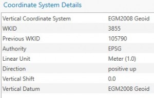
Before discussing why we need a VCS, let’s talk about what a VCS is. A vertical coordinate system defines the origin for height or depth values. A VCS is composed of the following components:
The key question we need to ask is why do we need a VCS in the first place? The answers are similar as why you would need a horizontal coordinate system (HCS). You need to be able to accurately locate real world features in your scene. This is especially important if you will edit the data, create new data, or perform analysis. GIS users know full well how frustrating it can be to come across undefined data or incorrectly defined data so it is essential not only to have the correct HCS but a VCS as well.
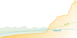
Some additional questions you need to ask are what units should I be using and am I modelling phenomena with positive heights above a surface or positive depths below a surface? Also, are these phenomena influenced by gravity and atmospheric forces that require a gravity-related VCS or are the vertical values relative to an ellipsoidal surface.
Adding Data
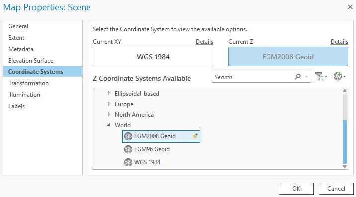
When you first add your data to ArcGIS Pro the vertical coordinate system of the scene is not set by default as the horizontal coordinate system is so you need to make sure this is set properly. Also, if you plan on converting your local scene to a global scene, you will need to make sure the global scene supports the VCS. Currently the global scene only supports ellipsoidal VCS as well as the EGM2008 and EGM96 gravity-related VCS. Local scenes support ellipsoidal and all gravity-related VCS. When you use an ellipsoidal vertical coordinate system, you must ensure that it matches the geographic coordinate system. For example, if z-value height is defined in NAD 1983, the geographic coordinate system must be defined in NAD 1983 also, not WGS 1984.
Transformations
One of the many reasons why ArcGIS Pro is so powerful is its support for vertical coordinate system transformations (i.e. projecting on the fly). You can have multiple layers with different VCS and ArcGIS Pro will properly project the data on the fly. Keep in mind that this does come at a cost for performance as the software is required to make the necessary calculations for the data to line up correctly.
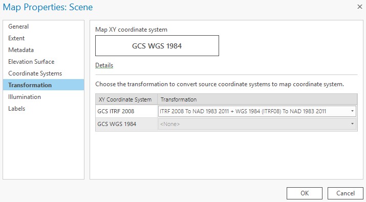
If you plan on using VCS transformations you need to make sure the ArcGIS Pro Coordinate System Data is installed. This is a separate installation from the default ArcGIS Pro install. This installation includes EGM2008, GEOID12b, and New Zealand Quasigeoid 2016 geoid models; VERTCON files; GEOCON v1; New Zealand transformations between local geoids/gravity-related VCS NZGD2000 or 2016 ellipsoidal heights;and NTv2 files for Canada, Spain, Switzerland, XRail, and OSTN15. Ellipsoid to Ellipsoid transformations use standard geographic transformations that support height. Ellipsoid to gravity-related transformation uses file-based VERTCON, geoid models or equation based methods. VCS transformations can be applied in the scene properties’ transformation tab.
Sharing Data
It is important to keep in mind the vertical coordinate system when converting the data or sharing the data to ArcGIS Online or Portal for ArcGIS. If you decide to create a scene layer package keep in mind that the VCS will need to be set in the tool. If you are sharing the data to a portal, the HCS and VCS information will be taken from the scene properties. Please ensure they are set properly prior to sharing to a portal. For a more in depth discussing on sharing across the platform see the global use cases blog.
Use cases
Note: The following use cases are examples only and are not professional recommendations on how data should be set up.
Water Wells
Project Requirements
Recent droughts across the planet have led to a boom in the water well business. With so many water wells needed for agricultural land and urban uses, it is essential that wells be drilled at an appropriate depth to reach the aquifer and ensure a sufficient amount of water over time. In this scenario, a gravity-related vertical coordinate system is necessary. With this in mind, the NAVD88 depth VCS will be sufficient for this project. Specifically, NAVD88 will be more suitable for the data as it is fit for North America and the project location is North American-based. Additionally, the Direction parameter is set to positive down so no parameter manipulation is necessary.
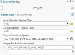
The well company has an empty feature class already created but the GIS Analyst needs to convert the data to use a new horizontal coordinate system and vertical coordinate system. The data currently is set to use WGS 1984 HCS. The GIS Manager would like the data to be in UTM Zone 11N NAD 1983 with VCS of NAVD88. The procedure for doing this is to use the Project Tool . The image below shows the desired HCS and VCS set as well as the proper transformation required to transform the data. As the data did not have VCS, only the HCS transformation is listed.
Once the feature class has been projected the GIS Analyst can now use it to add the new water well locations with the correct HCS and VCS.
Flood Mapping
Project Requirements
Like clockwork, rivers flood during the Spring. For cities that are situated along a river, flooding is a regular occurrence. What does change are the scale and severity of flooding during each season. Some floods may be mild and others more severe. Collecting data with a vertical coordinate system ensures accurate data is collected and can be compared against other datasets across time. For this use case, a gravity-related VCS is most appropriate. Specifically, NAVD88 (height) (ftUS) is a good fit as most of the city’s data are in a State Plane Coordinate System in units of feet. Another key parameter is that the direction is positive up. If the VCS was not set when the data was created it can be set properly using the Project Tool. With the VCS set, the city can confidently collect flood height data at different flood stages throughout the city.
Esri Campus Buildings
Project Requirements
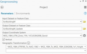
One of the principal reasons for a vertical coordinate system is accuracy for editing workflows. The Esri campus is expanding and recently an addition was added to building M on the north side of the building. As part of the building addition, accurate heights are necessary so the new building can be added to the existing building. For this project the existing multipatch feature class needed to be edited to include the new addition. The existing building had an HCS and VCS in State Plane but the new specifications require the projection to be in UTM. For this project, we will use the Project tool and apply a vertical transformation. The new output horizontal coordinate system will be UTM Zone 11N WGS 1984 with a vertical coordinate sysetm of EGM2008 Geoid. Once the data has been projected it is ready to edit to add the new building addition.



Article Discussion: