The latest release to ArcGIS Online has brought along many new enhancements to the scene viewer and support for new layers. We have made some changes to the interface to improve the experience within the app and your feedback from your comments on GeoNet and in our Holistic Labs has helped immensely. Check out the release notes below and also check out this story map the team created covering these new features here
Integrated Mesh Scene Layer
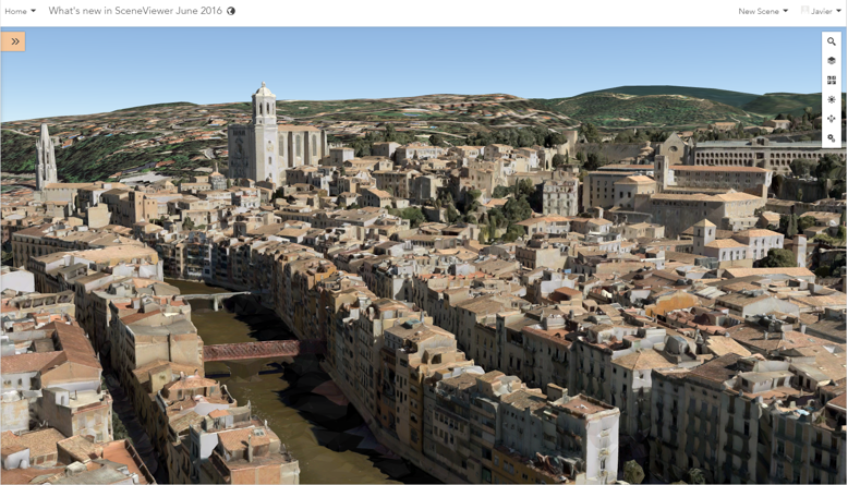
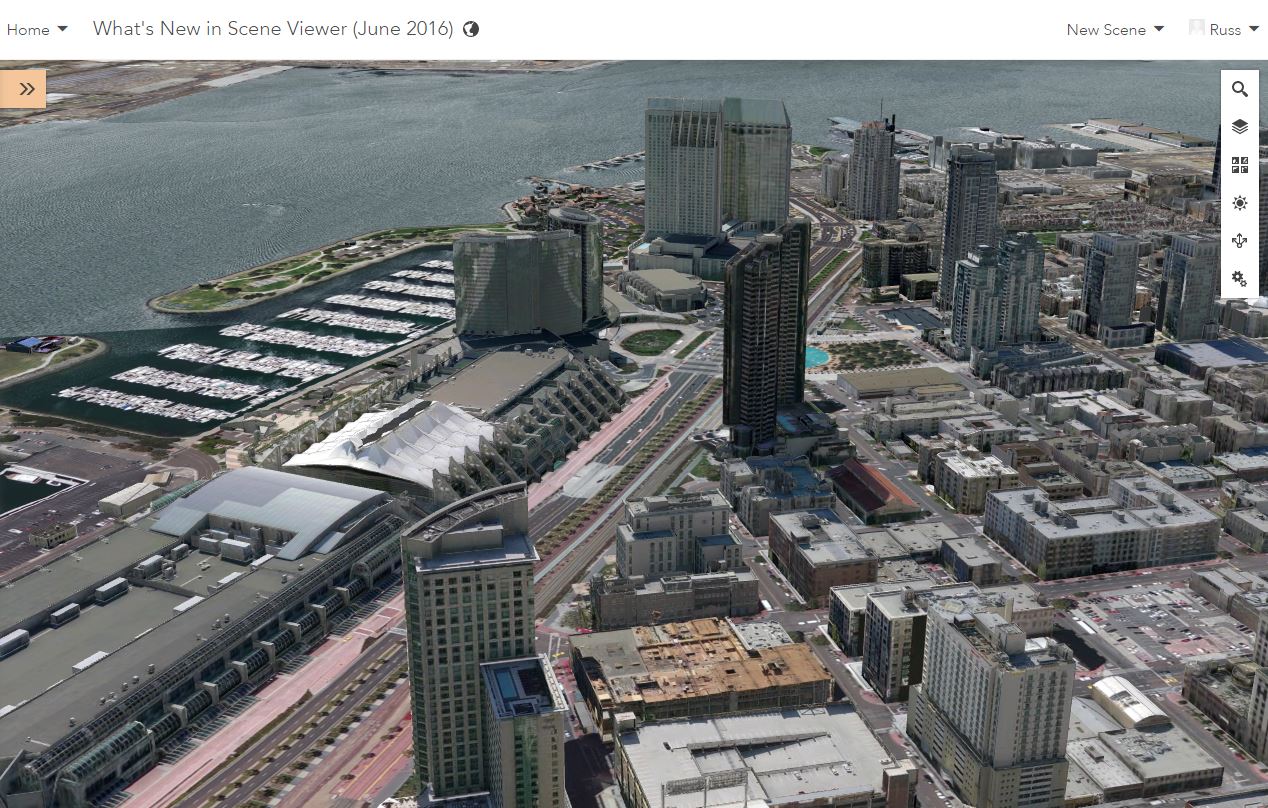
A new scene layer type has been included into this release. Integrated Mesh data is generated from oblique imagery captured by UAV or airplane based photogrammetry which will then be used to produce a textured mesh using a triangular interlaced structure. An integrated mesh layer can represent built features like buildings and natural 3D features like trees. These integrated mesh layers can be created and published by Drone2Map and third-part vendors. The Drone2Map application will create a scene layer package once the processing of your data has been completed and then it will share that scene package directly to your organization which will create a hosted scene layer that can then be used in the scene viewer. The below picture is displaying an Integrated Mesh layer comprised of buildings, bridges and trees.
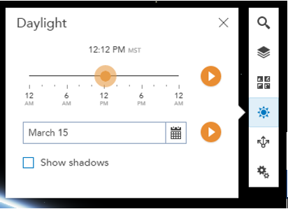
Daylight Widget
The Daylight tool is the new name for our new and improved Environment tool. This tool gives you control of the position of the sun by controlling the time of day and time of year. This can help you determine where the shadows of the objects being displayed will be positioned during a specific time of day & year. Another great addition to this tool is the ability to animate the sunlight as it cycles through the day or through the entire year.
Elevation Controls Updated
We have adjusted how you control your elevation layers in the scene viewer. When you add elevation layers to the scene viewer you will see them in the contents panel in the Ground section.

Clicking on the triangle next to the elevation layer will expose the options where you can further configure your elevation layers. You can decide to show or hide the elevation layer in the layer control tool where viewers of your scene have control to turn the elevation on or off. You can also change the ordering of the elevation layers which controls the display order of your elevation layers. If you do not want any elevation layers in your scene you can easily click the remove option but don’t worry there is an option to re-add the default elevation service to your scene.
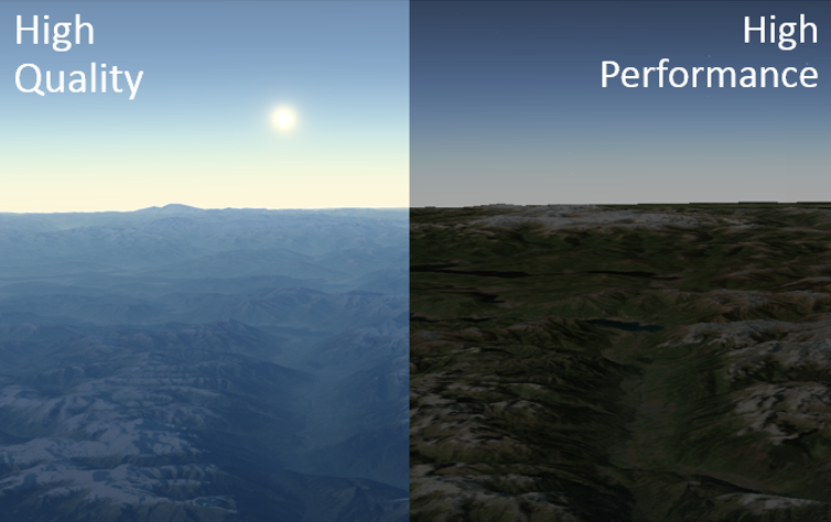
Performance Control
With this latest update to the scene viewer we have added a control that will allow you to control the performance of the scene viewer.
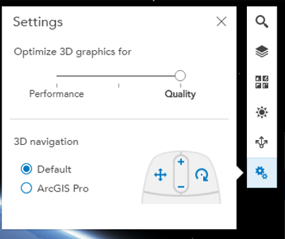
If you toggle the control to the Quality setting you will have higher-quality visualizations and you will also see the realistic atmosphere that was also added this release. Toggling the setting to Performance will increase the stability of the browser by reducing the data load when viewing scenes with larger scenes and disabling the atmospheric effect. This enhancement will greatly improve the experience of the scene viewer in Internet Explorer. If you are using IE it is recommended that you adjust the setting to Performance.
WGS84 Support
With global scenes in the scene viewer you will be able to use your WGS84 tiled data as basemaps, operational or elevation layers. If you want to use multiple tiled layers in your scene you will need to make sure they have the same tiling scheme. You can check out our new beta tiled map services with WGS84 coordinate system here . This beta service can be opened in the scene viewer today, simply click on Open in Scene Viewer on the item detail page and it will add it into a new web scene for you. Note this is a new feature in the June release of ArcGIS Online and is planned for the upcoming Portal for ArcGIS 10.5 release.
Improved Workflows for Creating 3D Content in ArcGIS Online Using ArcGIS Pro 1.3
With the upcoming release of ArcGIS Pro 1.3 around the corner we have been working hard on improving our workflows for creating 3D content that you can share to ArcGIS Online and Portal. Below I am going to cover these latest enhancements made for creating 3D content in ArcGIS Online.
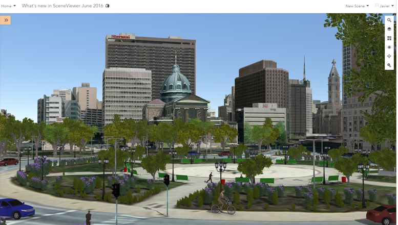
Custom 3D Object Symbols
When publishing point feature layers in Pro you can now use user-defined 3D objects such as street furniture or other custom 3D elements in scenes that you share from Pro to the scene viewer. These 3D objects you author in your scenes can have attribute driven rotation. In the example photo below you can see the cars, people and benches all have a unique direction which is driven by an attribute in the layer.
Creating Hosted Scene Layers
With Pro 1.3 you will be able to create scene layer packages from your multipatch data. Using the new Create Scene Layer Package tool you will select your multipatch data and a set of attributes within your data which will be displayed in the scene layers popup in the scene viewer. It is recommended for optimal performance to only include required attributes in you scene layer cache. Once you create your scene layer package you can then share your scene layer package to ArcGIS Online where you can publish a hosted scene layer to use in the scene viewer , 3D web apps and with custom apps built on the 4.0 JS API. The ability to create scene layer packages which can also be uploaded to ArcGIS Online to create hosted scene services will also be coming to CityEngine 2016.0 release which is planned to be out at the end of June.
Hosted Elevation Layers
In ArcGIS Online you can now create your own hosted elevation services. Being able to create your own hosted elevation services can now help you easily create scenes with elevation where the coordinate system might not match the Esri provided elevation data or you might have elevation data with a higher resolution. Using Pro 1.3 tools Manage Tile Cache and Export Tile Cache you can create a tile package that has LERC set for the tile format. When you upload this tile package to ArcGIS Online it will create a hosted elevation service that you can use in the scene viewer along with 3D web apps & 4.0 JS API.
When ArcGIS Pro 1.3 is released I will cover these workflows in greater detail walking you through the steps to create a scene with hosted scenes and elevation layers. Hope you enjoyed these exciting updates we are making. Please leave any comments or questions you have below.
Thanks,
Russ

Commenting is not enabled for this article.