Over the past few years, Esri has been making OpenStreetMap (OSM) data more easily accessible in ArcGIS. A few years ago, we published a new OSM Vector Basemap, which is featured in the basemap gallery and updated every few weeks with the latest OSM data. In the past few months, we published several OSM Feature Layers, which provide live access to OSM data and are updated every few minutes with the latest OSM data. In addition to this, we have been helping enhance OSM with high-quality data from the ArcGIS user community.
Earlier this year, Esri assembled some open data shared by ArcGIS users and then added this data into OpenStreetMap (using the ArcGIS Editor for OSM) following their import guidelines. This was done for building footprints and address points in the cities of Redlands, California and Flagstaff, Arizona (two of my favorite places). With the support of these cities, and a couple weeks of effort, we were able to add over 100,000 useful features that did not previously exist in OSM! This data soon became available to ArcGIS users through the OSM Feature Layers and the OSM Vector Basemap described above, and is now also available for other use cases such as geocoding.

Updated OSM Editors
Building on the success of that effort, we have been doing some additional work with our user community and partners that we hope will lead to much broader enhancements to the OSM data. In collaboration with Facebook, we are excited to announce the availability of an updated version of RapiD and an updated Map With AI plugin for JOSM, which each add support for ArcGIS Datasets (such as below) to be added to OpenStreetMap. We have been supporting developers at Facebook to enhance the RapiD and JOSM editors so that they can access open ArcGIS feature layers hosted in ArcGIS Online, and curated by Esri.
How it Works
RapiD is a variation of the popular iD editor, which is the default editor on openstreetmap.org. RapiD was developed by Facebook as a way to add and edit map features generated by Artificial Intelligence (AI) predictions, such as roads and buildings. RapiD suggests features that may be missing in OSM and enables the OSM mapper to decide which features to add to the map. A mapper can select a suggested feature, make any additional edits based on imagery or local knowledge, and then add it to the map.
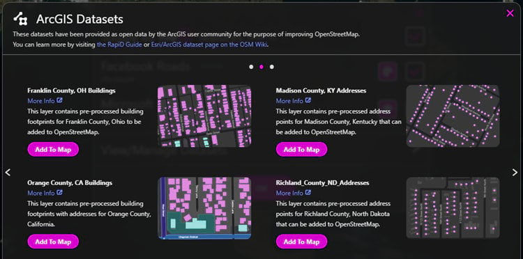
In this updated version of RapiD, there is now an option to View/Manage Datasets, which features a collection of open ArcGIS Datasets that are also available to use for editing. Esri has assembled this data from the ArcGIS user community, verified that it is compatible with the OSM Open Database License, processed the data for integration with OSM, published the data to ArcGIS Online as feature layers, and curated the layers into this group to be accessed by RapiD and JOSM, or other OSM editor apps (pause to catch breath). You can see a complete list of the available ArcGIS Datasets on the OSM Wiki, including data that is available to edit and data that is available to review.
The main benefits of the ArcGIS Datasets relative to the AI generated datasets in RapiD and JOSM are that most of the features have already been hand-edited by GIS pros and include more fields (e.g. name, address, height, etc.) that are populated with useful data from the local data provider (e.g. city or county). In addition, Esri has done some extra data processing to normalize the fields from the various local data providers to the expected fields of the local OSM community (e.g. convert ‘Street’ = ‘W Main St’ to ‘addr:street’ = ‘West Main Street’).
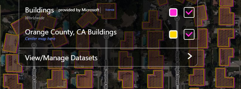
Using RapiD, you can select one of the ArcGIS Datasets (e.g. Orange County, CA Buildings, such as above), center map on that dataset, and zoom in to an area where you would like to make edits. RapiD will only display the features that do not conflict with existing features in OSM so that you don’t accidentally duplicate or replace those features.
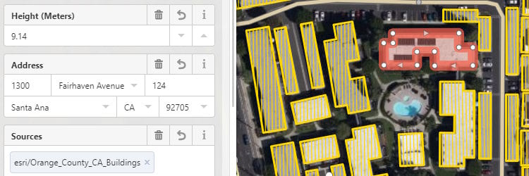
When you select a feature and click “Use this Feature” in the feature editor, a set of fields will be populated from the feature in the ArcGIS dataset, which may vary by dataset and feature. You can review and edit the values of these fields (such as below) or add values for more fields. You can then repeat the process for more features. When you are done with the edits you’d like to make, you can save your edits and upload your changes to OSM. RapiD will add a few tags for your changes, including the data source used.
The updated Map With AI plugin for JOSM enables similar capabilities for accessing the ArcGIS Datasets to edit OSM, while taking advantage of the other advanced editing tools of JOSM. If you are relatively new to editing OSM, the updated version of RapiD would be a great place to start. If you are an experienced OSM mapper and JOSM user, you will probably want to try out the new plugin.
How to Participate
If you maintain GIS data that would be useful for OSM (e.g. buildings, addresses, roads, etc.) and would like that data to be available in OSM editors so it can be added to OpenStreetMap for access by you and others, you have a few options for how you can participate:
- Community Maps: share your data through the Esri Community Maps Program and enable the new data sharing option for your contributions. As your data is accepted into Community Maps, Esri will also make relevant data available to OSM and other mapping platforms.
- ArcGIS Open Data: publish your data as feature layers in ArcGIS Online, have your administrator enable open data for your organization, and then share your feature layers publicly and with public group available to open data sites. Alternatively, you can create an ArcGIS Hub site and share your data there. To enable your data to be used in OSM, you need to specify an appropriate open data license (e.g. CC0, Public Domain) in the Terms of Use section of your feature layer item. Once the data is shared, email a link to osm@esri.com so we can download and process the data.
- ArcGIS Online: if you prefer, you can simply add the data to ArcGIS Online (as layer package or feature layer with export enabled), specify an appropriate open data license in the item, and share publicly. Once the data is shared, email a link to osm@esri.com.
If you would like to use these editors to help enhance OSM in your community and other areas of interest, you can sign up to OSM, get familiar with how to add data, and then start using the RapiD, JOSM, or other OSM editors. As you make edits to OSM, they will quickly appear in the Esri-hosted OSM Feature Layers and later the OSM Vector Basemaps.
We are excited to help make high-quality, open data from the ArcGIS community more accessible to the OSM community and look forward to seeing how we can collectively make OpenStreetMap even better for everyone.
We’d like to thank the World AI maps team at Facebook Boston and the larger Map With AI team for all their work on this release, as well as the GIS teams at the City of Redlands, City of Flagstaff, SanGIS, and these other organizations for sharing their data with Esri and the larger mapping community.

Article Discussion: