You’ve just finished manually editing hundreds, maybe even thousands of features in ArcGIS Online. Although the dataset is in great shape, you’re already preparing for the next time you need to update it with the latest information. Fortunately, ArcGIS Online’s Update Data* experience does all the hard work for you. It will complete bulk updates in a fraction of the time and effort as doing it manually.
This blog will walk through the ArcGIS Online June 2023 update which includes , what Update Data is, when to use it, and what has changed.
*Note: You may be familiar with ArcGIS Online’s previous method for bulk updates, Append. Append has now been renamed to Update Data, but most of the functionality remains the same. Check out the what’s new section to learn what has changed or view our related blog: Unpacking the new Update Data experience.
What is Update Data?
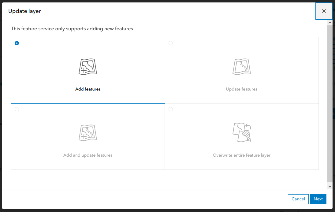
Update Data (excluding the option to overwrite entire feature layer) will add spatial and/or attribute information to your ArcGIS Online hosted feature service*. Whether you are adding in new features, updating attribute information for preexisting features, or changing the geometry of a feature, it is adding something new to the dataset. For a breakdown of each workflow in Update Data, see the table below.
*Note: When adding or updating features, the data will never be removed or deleted. Additionally, this update does not support attachments or schema changes.
Update Data Workflow |
Behavior |
|
Add features
|
Add features inserts new data into your hosted feature layer. This workflow has no way to detect matching features, so if your uploaded file contains preexisting features, Add features will insert duplicates. |
|
Update features
|
Update features changes the attributes and/or geometry of your data. It requires a unique identification field to pair incoming data with what is in your hosted feature layer. |
|
Add and update features
|
Add and update features combines both of the workflows above. It inserts new features and updates the attributes and/or geometry of your preexisting data. As with updating features, Add and update features requires a unique identification field. |
|
Overwrite entire feature layer
|
Overwrite entire feature layer deletes the ArcGIS Online hosted feature service and replaces it with the data in your updated file. The file name and schema must match before overwriting. |
What do you need to add or update features?
To make bulk updates with Update Data, you will need the following:
- An ArcGIS Online hosted feature layer or hosted table
- A supported file type containing your updated information
- A unique identification attribute field (not required for Add features)
Where can you access Update Data?
- The Update Data button on the Item Details page
- The Update Data button on the layer’s details page*
- Through the Options menu on the Data tab*
*Note: The option to Overwrite entire feature layer is not available through these entry points.
When do you use Overwrite instead of Update?
Overwrite entire feature layer will delete your ArcGIS Online hosted feature layer and recreate it with the data in the uploaded file*. This is different than updating or adding features, which will insert features or alter preexisting information in your dataset. Essentially, overwrite should be reserved for special use cases and it is not recommended to be a regular part of your workflow.
Additionally, your data is still available to other users while you are adding, updating or adding & updating features. Since overwrite deletes the original hosted feature service, the data will be inaccessible for a period of time. This is particularly relevant for large or public facing datasets.
*Note: The file must have the same name and field structure to successfully overwrite.

What is new with Update Data?
New terminology
As previously mentioned, the naming and language previously used in Append (now Update Data) has changed. Although the core functionality of remains the same, the language used in each of the workflows may have been altered slightly. See the Update Data workflow table above to clarify the behavior of any workflows.
Redesigned workflows
In the original Append experience, the update settings and field matching selections were all on one page. Now, Update Data is broken out into four separate workflows:
- Add features
- Update features
- Add and update features
- Overwrite entire feature layer
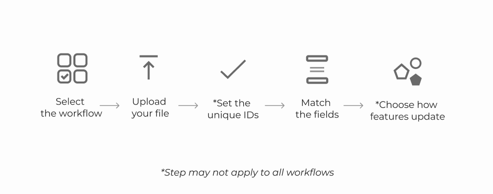
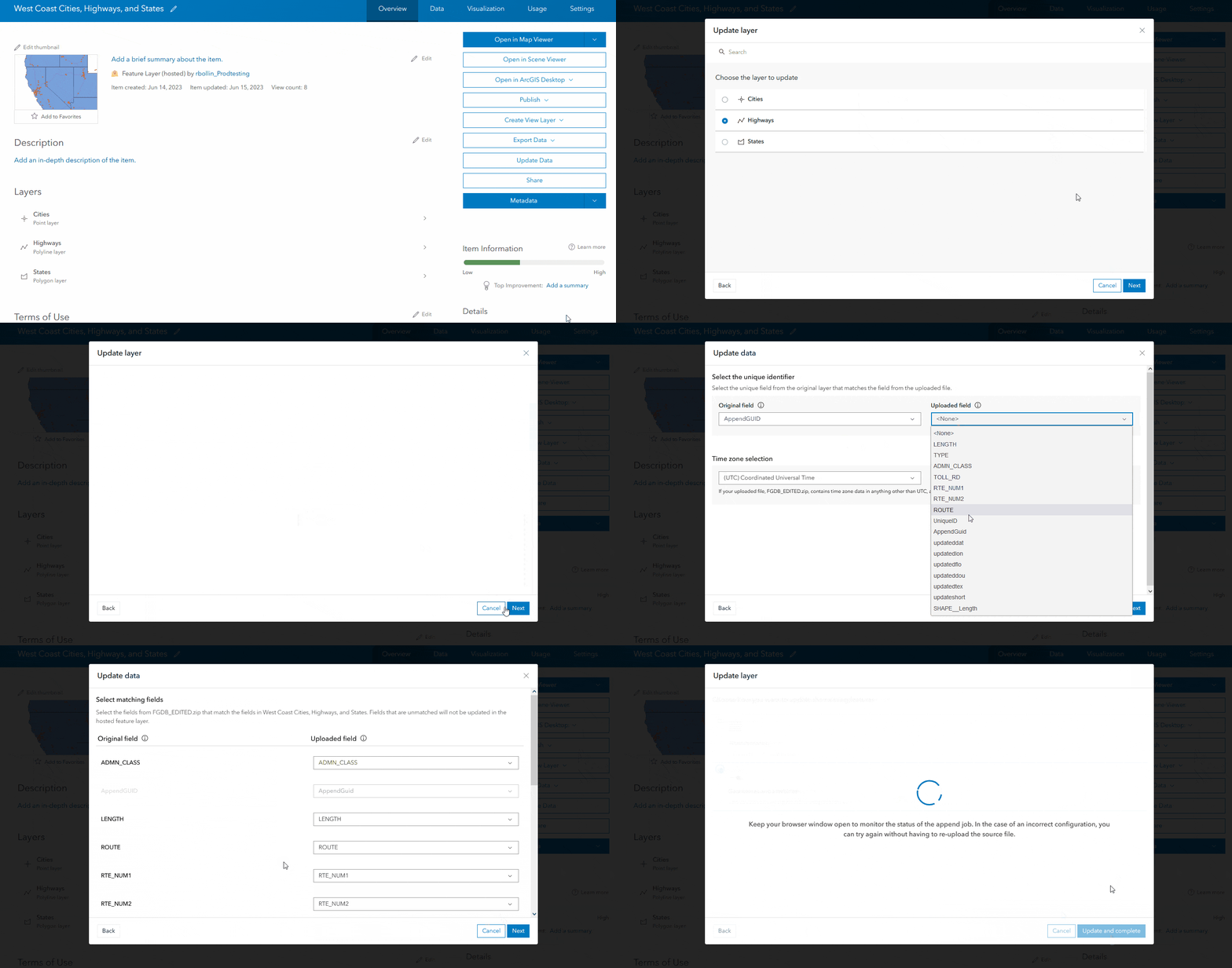
Each workflow will walk you through updating your hosted feature layer step-by-step. The general process for updating data can been seen below.


Support for new file and location types
Aside from giving Update Data a new look and streamlined experience, we have also implemented additional support for new file and location types. Leveraging the new experience, you can now:
- Upload OGC GeoPackage files
- Use additional location options like MGRS coordinates, USNG coordinates, or geocoding addresses for CSV and Excel files
- Select a time zone for your uploaded file if it was created in something other than standard UTC

For a deeper dive the changes we have made, view our related blog: Unpacking the new Update Data experience.
Summary
The June 2023 ArcGIS Online update has brought many exciting improvements for data management workflows, including a clearer and more comprehensive way to update your hosted feature layers. Whether you have been performing bulk updates for years or just now learning, Update Data has something to offer for all users. So the next time you need to change a few attributes for or insert new features into a dataset, save yourself the time and energy by using Update Data!


Hello! It was not discussed on what User Type and Role is able to Update a feature layer.
Hi Krystal, you must be the owner or administrator to update a feature layer.