Summary: I3S, the Indexed 3D Scene Layer Specification, was released to the community as an open standard in 2015 and was adopted as an OGC Community Standard in 2017. Recently, the public spec version contributed to by Esri has been updated to include layers for massive point clouds, detailed buildings sourced from Building Information Modeling (BIM) data, and improvements for readability and performance.
An open standard for streaming 3D content
In 2015, Esri introduced Indexed 3D Scene (I3S) layers as an open specification shared through Creative Commons as a technology for packaging and streaming large, heterogeneously distributed 3D data sets. Initially, the specification was introduced with two layer options, 3D Object and 3D Point. In early 2016, we added Integrated Mesh layers to the specification to support large reality capture mesh data sets and later that year, we also started the process of submitting I3S to the Open Geospatial Consortium (OGC) to be considered as a Community Standard. I3S was adopted as an OGC Community Standard in 2017 and we’ve made minor updates to the specification since then.
I3S content is used throughout the ArcGIS platform and we are aware of several well-known vendors who create I3S content and even a few open source efforts to serve it out and consume it in client experiences. In fact, I3S could be created, served, and consumed without the use of any Esri technology and we know of one European company, Melown Technologies, who can do just that. We’ve been grateful for all of the feedback and input from partners and customers who have helped the specification improve and evolve and become better adopted across the world.
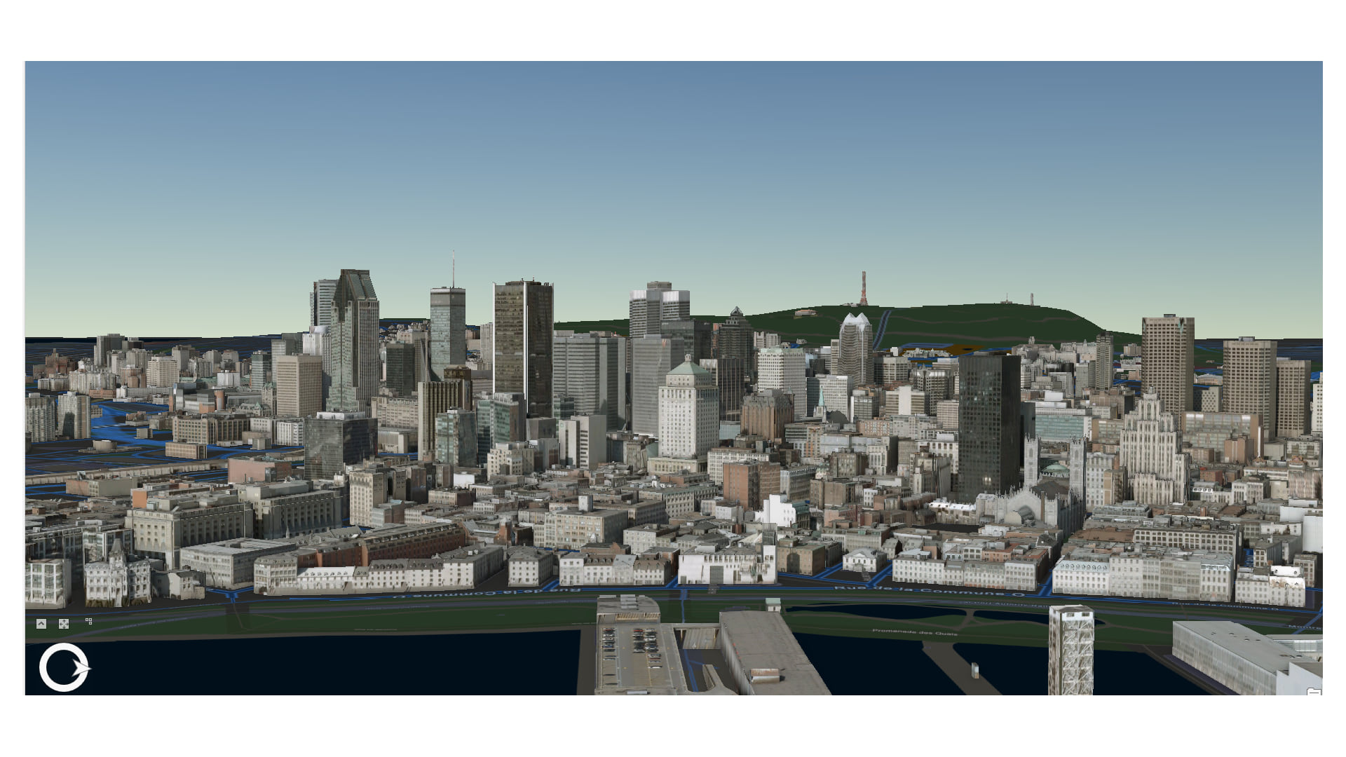
An I3S data set, also referred to as a scene layer, can be streamed over the web or it can be viewed locally as large packages of content. ArcGIS Pro and ArcGIS Earth both consume scene layers either as services or as local scene layer package (SLPK) files. The Scene Viewer in ArcGIS Online and ArcGIS Enterprise is Esri’s WebGL 3D viewer and can consume I3S services coming from anywhere. In fact a huge benefit of the Scene Viewer and other Esri experiences is that they are built to consume a wide variety of open and Esri formats, all of which can be viewed together in the same experience.
Now that I3S has been out in the community for a few years, we are introducing some updates to improve readability, enhance the documentation, improve performance, and even expand the types of data that can be shared through scene layers.
I3S improvements and additions
Working with outside contributors, we have made strides to expand and improve the I3S specification. Some of the improvements that you will find include:
- Updated Point Cloud Scene Layer specification
- New Building Scene Layer specification
- Improvements to the 3D Object Scene Layer
- Cleaned up documentation
- New versioning pattern to support incremental updates to layers and the specification
3D Object Scene Layer improvements (1.6)
3D Object scene layers are typically used to represent assets including building shells, subsurface geological meshes, and schematic shapes representing 3D volumes and objects that may be derived from analytical operations.
Improvements to the 3D Object scene layer specification include:
- Oriented Bounding Boxes (OBB) – Spec improvements introduce support for oriented bounding boxes to define the bounding volumes used for the multi-LOD node hierarchy within the layer. OBBs allow content creators to more accurately specify the enclosing shape the contains the graphical content within each node, enabling client software to provide a better experience for retrieving and displaying content.
- Attribute (Field) Domain – Content creators can now specify attribute domains to constrain the values that can be used for each attribute or field within a data set. Attribute domains are useful for ensuring data integrity and improving the experience around defining queries and displaying attribute content. Domains can be continuous numeric ranges or discreet string values and have other properties that may be specified by the content creator.
- serviceUpdateTimeStamp – Included in the scene layer descriptors is now a time stamp that can be used to track the last updated time of the whole layer. Esri uses this in the pattern in which we link a feature service to the scene layer to enable updates and seamless recacheing.
Point Cloud Scene Layers proposed to OGC
In the last few years, one of the largest areas of 3D data collection has emerged from the collection and creation of different kinds of point cloud data. Whether from aerial or terrestrial sensor-based lidar data capture or from the extraction of 3D point clouds from structure-from-motion photogrammetry workflows, we have seen an explosion in the amount of point cloud data available for customers to visualize, analyze, and share.
Since ArcGIS Pro 2.1, we have allowed users to create, share, and view a new scene layer type for point clouds. The SceneViewer in ArcGIS Online and ArcGIS Enterprise has allowed users to view point clouds in web experiences since approximately the same time. The Point Cloud Scene Layer provides a compressed, streamable data set that can be hosted in ArcGIS Online or ArcGIS Enterprise or even accessed locally on disk. Point cloud scene layers can be created from LAS datasets and can support LAS, ZLAS, and LAZ file sources. Users can set and change symbology and filters depending on the information available in the source data. Point cloud scene layers can be used to share and visualize billions of points over the web and even on mobile devices.
Currently, the OGC community is considering adoption of the point cloud scene layer specification as an addition to the OGC Community Standard version of I3S. That process may take several months, but Esri will continue to grow and support I3S point clouds into the future.
")
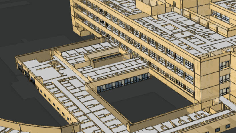
Building Scene Layers
Another area in which we’re experiencing high demand is in the Architecture, Engineering, and Construction (AEC) market. Much of the need in this market is for the better integration of GIS with Building Information Modeling (BIM) content. Users want better integration to enable analysis, viewing, and designing buildings and infrastructure in real world context. Users are also hoping that, through better integration, more information from BIM designs can make its way into the full life cycle management of assets and structures.
Beyond classic CAD data, BIM content can include schedules, bills of materials, civil infrastructure models, and architectural models. ArcGIS for AutoCAD and the ability to read CAD files in ArcGIS Pro helps customers with CAD data management and reading. After CAD files, the single largest source of demand we hear about is for the ability to view and read content from 3D architectural design packages, such as Autodesk Revit®. For that reason, we released capability last year in ArcGIS Pro to be able to directly read Revit files and to interact with them as special building layers in ArcGIS Pro.
This year, we have released the ability to publish a building layer as a streamable I3S scene layer, a Building Scene Layer. The Building Scene Layer encapsulates the semantic structure of the information in the building model while capturing geometry and attributes that can be used in GIS.

With a Building Scene Layer, you can:
- Generate a scene layer package file (SLPK) encapsulating the building information
- Open and visualize the layer as local file content (SLPK) with ArcGIS Pro
- Share the SLPK to ArcGIS Online or ArcGIS Enterprise and publish it as a web layer
- View and inspect published layers in the SceneViewer or in ArcGIS Pro
- Create visual filters on the content in ArcGIS Pro
For the future, we are looking at improving the Building Scene Layer capability to include:
- Publishing more than one building or file to a Building Scene Layer
- Update workflows to add more models or delete or update content in a layer
- 3D materials to better represent models coming from Revit and other high-end design packages
- IFC, GDB, and other sources for Building Scene Layers
Improvements to versioning of the I3S specification
When I3S was originally released in 2015, we thought that it would be versioned as a single specification that could offer improvements to performance, new layer types, and other new features. What we’ve realized over the last few years is that I3S needs to be versioned in a different pattern that can allow for updates to the overall spec, updates to specific layers, and to prevent version update for layers and content that are not changing.
A quick look at the I3S specification will show that we are now versioning the spec per layer profile. This will allow, for example, for the addition of a new profile type without forcing update of other profiles. This helps ensure that users of the spec can reliably generate content without having to update or reissue content only for the sake of chasing version numbers.
What can you do with I3S?
I3S provides an essential pathway to share massive, heterogeneous 3D geospatial data sets that can be viewed, explored, and analyzed across ArcGIS apps and other non-Esri technologies such as the FOSS stack built by the Czech company, Melown. Potentially, anyone could build a complete 3D GIS capability with I3S at its heart for five different content types (and growing). There are no commercial restrictions on anyone who would want to create, consume, or build other workflows around I3S content.
Within Esri applications, I3S can be:
- Created using ArcGIS Pro (3D Object, 3D Point, Building, and Point cloud scene layers)
- Created using ArcGIS Online and ArcGIS Enterprise (3D Object and 3D Point)
- Created using Esri CityEngine (3D Object)
- Created using ArcGIS Drone2Map (Integrated Mesh scene layers)
- Shared to and Published in ArcGIS Online and ArcGIS Enterprise
- Viewed in ArcGIS Pro, ArcGIS Enterprise, and ArcGIS Online (all types) and ArcGIS Runtime and ArcGIS Earth (3D Object and Integrated Mesh scene layers with Point Clouds coming soon)
- Used in interactive analysis tools in ArcGIS Pro, ArcGIS Earth, the SceneViewer, and in custom ArcGIS API for JavaScript and ArcGIS Runtime SDK apps
- Consumed as services (SceneViewer, ArcGIS Pro, ArcGIS Earth, ArcGIS Runtime) and as local files (ArcGIS Pro, ArcGIS Earth, ArcGIS Runtime)
- Updated when published as scene layers with associated feature services (3D Object and 3D Point currently in some ArcGIS Pro workflows)
- Symbolized using smart mapping and intrinsic layer symbology in the SceneViewer, ArcGIS Pro, and other apps
- Snapped to for 3D editing workflows in ArcGIS Pro
- Validated using the Validate Scene Layer GP tool in ArcGIS Pro
- Combined with other layers including 2D content, rasters, and I3S to create rich 3D maps and scenes
- … and much more
As you can see, some of the workflows apply to only some scene layer types and others are still being built for all scene layer types. Every scene layer is an enterprise content type and it takes time for us to build out all of the capability that is needed to support a layer across the ArcGIS platform.
Beyond Esri, you can also find scene layers being created by Vricon, Bentley ContextCapture, Skyline Systems Photomesh, Nearmap, Pix4D, Melown, Safe Software FME, and other technologies and companies. There have even been some great experiments sent to us occasionally by grad students creating simple open web apps using tools such as ThreeJS to consume and visualize I3S services.

Where is I3S headed next?
At Esri, we’re really just getting started with I3S. 3D has become an essential aspect of the GIS technology story and is helping customers solve problems and communicate in domains as diverse as Oil and Gas, Agriculture, and Urban Planning.
Some of the areas we’re working on for the future include:
- Expanding the number of scene layers to accommodate volumetric information (voxels) and transportation information (more BIM)
- Continuing to build out enterprise capability for existing layers
- An SDK to validate and create scene layers
- Geoprocessing using scene layers
- Adding capabilities such as 3D materials and temporal information to enable better visualization and analysis workflows
As you can see, we have a lot more on our plan regarding I3S, 3D, and GIS. Unfortunately, we can’t share all of the details of timing for some of these bigger ticket items. We would love to hear from you about what and when you want to see some of these new things or other features and extensions to I3S appear in ArcGIS.

Commenting is not enabled for this article.