Estimated Read Time: 6 min
Keeping shared data in your organization’s portal current is a common challenge, especially when multiple teams rely on the same data for their research, maps, or webapps.
To handle frequent updates or complex field matching, look no further than the ArcGIS Pro Append tool to add new data or update existing records in your feature service.
This blog will cover the Append tool, how to use it, and highlight new features for feature services in ArcGIS Pro 3.5!
About the ArcGIS Pro Append Tool
The Append tool provides a way to add (and optionally update) data to an existing dataset. Think of it like copying and pasting rows from one table into another, but smarter. When you add new rows, you can either add everything (even duplicates) or update existing records based on a matching ID field.

The Append tool is great for keeping a dataset fresh without having to rebuild it from scratch each time you receive new or updated data. And it works with feature services, so you can push any changes directly to feature layers in your organization’s portal.
Append tool updates for feature services in Pro 3.5
Feature Services are vector and tabular data shared over the web or an internal network using ArcGIS Enterprise or ArcGIS Online. This allows users to access, query, and update layers from desktop, web and mobile apps. In ArcGIS Pro, you can use Append to update feature layers copied to a server or that reference registered data.
When managing feature services, particularly those with large or frequently changing layers, the faster the update, the better. So, in ArcGIS Pro 3.5, the Append tool has a new Optimize performance for feature services parameter to speed up processing.
Note: In Pro 3.5, only the data owner or administrators can enable optimization.

This new parameter is enabled when the Target Dataset is a web layer and the supportsAppend metadata property is True. Appending data in an Enterprise feature service also requires that editing is enabled with Add, Delete, or Update (which enables the uploads capability).
Note: View a layers supported properties in its ArcGIS REST Services Directory page.
How it works
When supported, the Optimize performance for feature services parameter is enabled by default and will improve efficiency in the following ways:
- Improves overall performance by minimizing the number of server requests during an append operation by using the Append REST API. So, rather than appending the inputs to the target record-by-record, optimization uses server-side processing where the entire input dataset is sent to the feature service Append API in bulk.
- When using Update Options, the Append REST API
upsertcapability is used for improved performance, and FeatureIds (ObjectIds, GlobalIds) will be preserved. - The Target Dataset can be branch-versioned feature service data.
Keep the following considerations in mind when using the optimization parameter:
- The Update Options only work with one Input Dataset at a time and one set of Matching Fields for Update. Only fields with a unique index can be used for updates.
Note: Use the Add Attribute Index tool create unique indexed fields. - The Expression and Enforce Domains parameters are not supported.
- In Pro 3.5, the target geometry will always update when you specify an Update Option.
- Optimization is not supported when Pro has an active edit session. If you toggle on Enable Undo, the parameter will be ignored.
You can always disable the optimize parameter if your workflow requires the options above.
Example: Update feature services with Append
Objective: Use the Append tool to add new features and update existing features for a zoning layer in your organization’s portal.
Data: You started your first GIS internship at the Town of Cary, NC. For your first assignment, you must update zoning data within zip code 27519. You receive access to 2 feature layers in your organization’s portal: current_zones and rezoned areas.

In the map above, notice that some zones are new and others overlap existing areas, so you’ll need to insert and update features in the current_zones feature layer.
To update existing zones, match features based on an ID field with matching values.
current_zones; N=959 records
| OID | GlobalId | ZoneClass | Acres |
| 1 | {E1D8048B-B46E-4382-A831-BB3E445BEADA} | PDD | 0.79 |
| 2 | {0DCA3209-3564-4923-81F6-7A39CCFAAFB5} | PDD | 1.019 |
| 3 | {F9829500-EAAF-4885-B074-0CDDDC513DED} | Residential | 2.11 |
rezone; N=24 records
| OID | GlobalId | ProposedZone | Acres |
| 1 | {154E0C3E-F492-42AB-A38D-90A2AB9F4E65} | ORD | 0.79 |
| 2 | {6AFD699A-26D0-4234-8061-1BB5D29CA569} | Residential | 1.02 |
| 3 | {CA1B21B3-7C53-4ADB-8860-C210AE416510} | Residential | 3.3 |
Both tables contain a GlobalId field. So, features with a matching GlobalId value in both the input and target will get updated with a new zone class. The remaining non-matching features will get appended to the bottom of current_zones.
Use Append to update and insert data
Open the Append tool and set the following parameters:

1. Target Dataset: current_zones
2. Optimize performance for feature services will automatically enable.
3. Input Datasets: proposed_rezone
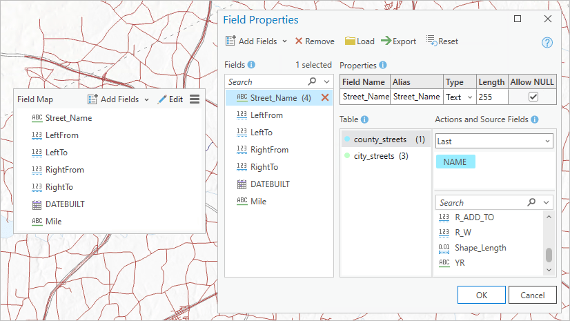
4. Field Matching Type: Use the field map to reconcile field differences
Selecting this option will activate the field map, which you can use to match the fields:
zoneclass ; ProposedZone
acres ; acres
GlobalId ; GlobalId
Learn more about how to use the field map for field matching
5. Matching Fields for Update: GlobalId ; GlobalId
Run the tool
Result: The existing zones will update with a new zone class, and the new rezoned areas will be added to the feature layer!

Summary
In ArcGIS Pro 3.5, the Append tool can now optimize feature service updates using the new Optimize performance for feature services parameter. The parameter is available when the target dataset is a feature service. It uses the Append REST API to append and update features, which improves performance by minimizing the number of server requests when you run the tool.
Bonus: More ways to update feature services
There are multiple ways to update feature services using ArcGIS Online, ArcGIS Pro, or Python scripts. Other methods include the following:
- Update Data – In ArcGIS Online, a hosted feature layers item page includes an Update Data option. Use this option to overwrite, update, or add new features to an existing hosted feature layer.
- OverwriteFS– Use this Python script to automate data updates for hosted feature layers.


Commenting is not enabled for this article.