Early in my career, I spent hours collecting data using a handheld GPS. I marked waypoints for hundreds of points of interest. I was one of those “cool” people who clipped a GPS to their backpack. When smartphones started being used as an alternative to a dedicated GPS, I was skeptical. How could my phone perform as well as my GPS unit?
Earlier this year, I was prepping for fieldwork in Guatemala and decided to put it to the test. I took out my phone, marked waypoints, and did a comparison using my GPS unit. To my surprise, the smartphone performed as well as my GPS—and it was significantly easier to export my data to my computer. That’s when I decided to try ArcGIS QuickCapture, and now I’m a convert. I saved hours of time and found it easy to integrate the field data into ArcGIS StoryMaps. Together, these tools allow you to create a seamless mobile-to-web workflow.
In this blog, I’ll show you how to integrate data from ArcGIS QuickCapture to ArcGIS StoryMaps.

Why collect field data?
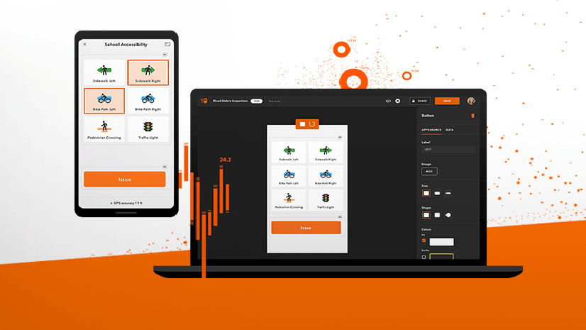
ArcGIS QuickCapture is Esri’s rapid data collection app for field data collection. It simplifies collecting location-specific information, such as photos, notes, or observations. ArcGIS QuickCapture is particularly effective at photo-based workflows like infrastructure inspection, disaster response, field research, and even documenting biodiversity. Users can create customized projects with predefined data fields to collect data on the go.
After you collect data, it’s easy to bring into ArcGIS StoryMaps. This integration provides context for the data and aids in decision-making. With this workflow, your story will also update in real-time as you collect more data since it’s linked to a live feature service.
How to integrate ArcGIS QuickCapture and StoryMaps
I’ll demonstrate how you can integrate these two tools using this example workflow I used recently to produce a story about finding mushrooms in Maine.
Create your ArcGIS QuickCapture project
The first step is to create your data collection project in ArcGIS QuickCapture. If you’re new to ArcGIS QuickCapture, I recommend starting with one of the many great templates. If you want to build a custom project from scratch, I recommend developing one based on an existing feature layer in your ArcGIS Online account. Regardless of your approach, ensure your project includes a question requiring a photo. Here are some helpful tips I learned from the Mushroom Finder story:
- To allow the collection of photos from ArcGIS QuickCapture, I enabled attachments in my feature layer
- I used custom PNG and SVG icons to make my QuickCapture buttons look good and represent the data I was collecting
- I also configured my QuickCapture project with a custom map
This resource has all the information you need to get started configuring your project.
Install the app and start collecting data
Next, install the ArcGIS QuickCapture app on your phone. When you sign in, you’ll be able to select your project. Open your project and start collecting data. As you capture data, the app records the photo, location, time, and any additional information you’ve defined. The data you capture is automatically added to the feature layer you configured in the previous step in ArcGIS Online.
Build your story in ArcGIS StoryMaps
With your field data now available in ArcGIS Online, it’s time to craft your story in ArcGIS StoryMaps. Start by creating a new story or editing an existing one. The story should provide context for the data you’re collecting.
Add your mobile data by adding a map tour block from the block palette. Select Start with a feature service and locate your feature layer from ArcGIS QuickCapture. In a few seconds, ArcGIS StoryMaps will take all your field data, place it on a map, and show your photos.
Choose the layout that works best for your data.
Once you’re happy with your story, publish it and share it with your audience. Whether you’re reporting on a live event, conducting field research, responding to emergencies, or inspecting a job site, integrating ArcGIS QuickCapture data into ArcGIS StoryMaps will captivate your audience.
ArcGIS QuickCapture and ArcGIS StoryMaps are powerful for location-based storytelling and data visualization. This integration offers a compelling way to engage your audience and convey the significance of your data. These steps allow you to blend real-time data collection with storytelling to create impactful, informative narratives.


Article Discussion: