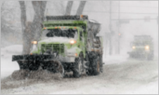
 The city of Sandy, Utah, receives approximately 75 inches of snow fall annually — nearly three times the average of a typical US city.
As a result, Sandy officials need to manage their snowplow fleet as efficiently as possible so they can keep the city functioning in the wake of paralyzing snow storms.
Oversee Snowplows in Real Time is a new Learn ArcGIS lesson using Operations Dashboard for ArcGIS, which helps officials create and share views of ongoing operations as well as monitor and respond to events.
In this 75-minute lesson, you will create two real-time apps: the first is for city officials who require immediate updates about road conditions and the second is for a public hungry for that same information.

Article Discussion: