ArcGIS Field Maps is a mobile app solution that allows you to streamline field workflows and take maps anywhere. You can use Field Maps to explore the maps you make in ArcGIS, collect and update your authoritative data, and record where you’ve gone, all within a single location-aware app. Field Maps includes a companion web app that allows you to configure the maps mobile workers use in the field.
Following our initial release in October 2020, we’ve received very positive feedback on the capabilities we’ve fused together and with the direction we are heading. Thank you for all of your wonderful feedback!
With each quarter we are releasing new capabilities. Let’s take a look at the Q2/June 2021 updates…
Sharing maps
Within the Field Maps web app, you’ll find a great new experience for sharing the maps you’ve configured:
- First, you’ll see how the map is currently being shared. By clicking the Set sharing level button, you can use the standard share dialog that you are familiar with to share your map and any dependent layers to the groups your mobile workers use.
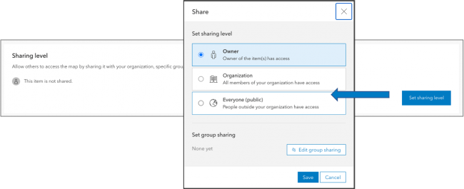
- After you’ve set the sharing level, Field Maps generates a unique, shortened URL that you can copy to the clipboard and paste into an email or text message that you prepare for your mobile workers. A QR code is also generated and can be scanned directly from the camera on your device. When mobile workers tap the link or scan the QR code on a mobile device, the map is opened in Field Maps. It’s never been this easy to deploy maps!!

- We moved the Hide in Field Maps mobile switch from the Overview page to the new Sharing page as well. Sharing is often the last step in the configuration process and the most natural place for you to provide access to maps.

Data Collection and Editing
ArcGIS Field Maps provides a number of different methods for capturing and editing the location of a GIS feature. The most common method is to tap Add  and either use GPS or the map to capture location. However, you can also select a feature, search for a location, or drop a pin and tap “Collect Here” and use that location to start your collection as well.
With this update, we are dramatically enhancing the Copy feature action so that you can copy the location of a feature, the location and attributes of a feature, or just the attributes of a feature (as supported in the current release).
You can control the behavior of the Copy feature action using the Field Maps web app for each map as well.

The Copy capability is extremely powerful, promotes efficiency in data capture, and supports all of the functionality of Collector Classic and more.
Delete All Points
We’ve added a new collection setting to the Field Maps web app that extends the collection menu so that you can delete all points within a line or area shape.

Shared Update Groups
Quite often multiple map authors need to collaborate when building and configuring maps. Shared update groups were introduced to support this effort but until now, the ArcGIS Field Maps web app required that the signed in user own the map. With support for shared update groups, now multiple map authors can configure the same map.
Smart Forms
With the initial release of Field Maps, we introduced smart forms. The new form capabilities are stored inside of your maps and their advanced editing logic is available within Map Viewer as well as within the Field Maps mobile app. An effort across ArcGIS, we continue to grow and evolve their capabilities.
Switch Input Type
Yes/No type questions are quite common on forms and in this update we are introducing a new Switch input type that you can choose from when formatting fields. Please note that your field needs to have a list with only 2 choices and a default value set.

iOS Smart Form Experience
The smart forms experience got a bit of a makeover on the iOS platform with this update.
- Readability
Completing a lengthy inspection form can challenging. The display name and description properties help guide each input but it is quite easy for text and inputs to blend together. Providing color contrast can dramatically improve readability, especially in direct sunlight conditions. - Text wrapping
When formatting fields, you can use the Display Name property to ask a question and the Description property to provide context on how field values are entered. This text can be quite long and instead of truncating the text on a small form factor it now wraps so you can read the information you need to fill out forms properly. - Accessory button images
There are a variety of input types that can be applied to a field and using an image for the accessory button, now you’ll know what type of input will appear when you tap on it. - Clearing field values
Once a value has been entered in a field, the accessory button can then be used to quickly clear the value you entered.

In addition to these quality of life improvements to smart forms, we’ve updated the Date/Time picker used when filling out a date field. The new calendar view is a significant improvement over the spinner previously used.

Conditional Visibility
We’ve made some quality of life improvements to the Field Maps web app in this update.
Conditional Visibility expressions can be re-used within the same form. You no longer need to copy the expression if it needs to be applied to multiple attributes or groups.

You can see which groups and attributes are using an expression:

Expressions can also be duplicated, edited, or deleted.

Location Tracking
If you are being billed for work by a contractor or being audited for your own project work, recording location history can provide the accounting you need. To ensure privacy, the mobile worker is in full control of when they start or stop recording their location. With this update, we’ve added a new map setting that requires the mobile worker to start tracking in order to use the map. That way, they will never forget to start tracking.
ArcGIS Runtime SDK
ArcGIS Field Maps is powered by an underlying engine called the ArcGIS Runtime. With this update to Field Maps, we have upgraded the Runtime to the latest version (100.11) so that you are ensured to get all of the quality improvements and mapping capabilities of the ArcGIS platform.
What’s coming next
If these numerous updates were not enough, here is a quick glimpse into 3 great new features that are in development now…
Web hooks
We are putting the finishing touches on support for web hooks with hosted feature layers in ArcGIS Online using Integromat. With a new Integromat app called ArcGIS Field Maps, we will streamline hooks into feature and table editing events so that you can implement business logic for both data collection and asset inspection workflows using Field Maps.
Utility Network support
We introduced an early access beta in May that provides support for viewing connectivity within a utility network, viewing contained network elements and support for tracing a network using named trace configurations. We’re continuing this beta program through most of 2021 and are looking for your feedback.
Phase 2 – Work management
We’ve started scoping phase 2 of ArcGIS Field Maps. It will include the work management capabilities of ArcGIS Workforce. This will be a significant development effort and we’ll announce an early adopter beta program late this year.
We have an aggressive road map for new features within ArcGIS Field Maps, and we want you to help shape our priorities. Please provide your ideas within the Esri community so that we know what is most important to you.


Article Discussion: