During the ArcGIS QuickCapture Introduction & What’s New webinar we received a number of great questions, some of which covered similar topics. In this blog we’ve addressed those topics. Whether you are watching for the first time, or want to refresh your memory, check out the webinar recording below:

Answering the questions…
We have grouped the questions into the following categories:
- Which field data collection app to use.
- GNSS
- Using ArcGIS QuickCapture with other applications
- Offline
- Oriented Imagery
- Public QuickCapture Projects
- Working with ArcGIS Enterprise
Which field data collection application should I use?
When collecting data in the field, it is important to use the correct tool to improve efficiency and maintain accuracy. Esri understands that not every field data collection activity is the same, they each come with different requirements and different end user needs. Esri provides 3 mobile apps for field data collection, each with distinct features, strengths and user experiences. It is up to the end user to decide what is most important for their field data workflow and choose the appropriate mobile app. Here is a high-level overview of the most prominent
- ArcGIS Field Maps is a data-driven mobile map app built for field teams. With Field Maps you can collect and edit both spatial and form-based data and find assets and information whilst in the field. A flexible, streamlined deployment environment ensures workflows can be iterated easily.
- ArcGIS Survey123 is a form-centric mobile app. These smart forms drive the user experience in Survey123, making it ideal for data collection workflows that traditionally have involved forms. With Survey123 you can model anything from the simplest to the most sophisticated forms and collect data from mobile, web and desktop devices.
- ArcGIS QuickCapture is a simple-to-use app that allows rapid data collection with minimal user involvement through a ‘big button’ interface. Users can easily tap a button to collect new data while traveling at-speed in a vehicle or while otherwise unable to use more interactive interfaces.
All 3 mobile data collection apps can do the following:
- Work with ArcGIS Online or ArcGIS Enterprise
- Work while connected or disconnected
- Share the user’s location

GNSS
Several questions concerned using QuickCapture with external GNSS devices. QuickCapture supports connecting to a GNSS receiver via Bluetooth (direct connection) or over a network port (indirect connection through a specialized application, usually used in scenarios with RTK or other corrections being applied). Additionally, you can store GNSS metadata to fields when geometry is captured. The standardized metadata fields are recognized automatically by QuickCapture Designer. One question that was asked was can this automatic recognition be disabled; the answer is yes, you can reset the value to a blank Fixed Value in QuickCapture Designer.

Using QuickCapture with other applications
Two different types of questions regarding using QuickCapture with Field Maps or Survey123 came in. The first is if the data collected by QuickCapture and Field Maps are compatible with each other; the answer is yes, both work with feature services and you can configure both applications to interact with the same feature service. This extends to the other applications and capabilities of your ArcGIS organization, including using QuickCapture data in applications like Dashboards and Experience Builder, as well as exporting the data into CSV or Excel for processing in other applications.
Another question that was asked in a few different ways concerned how QuickCapture could be integrated with workflows involving Field Maps or Survey123. This can be done through application URLs accessible in the app. QuickCapture supports buttons that launch a URL; this allows you to open up Survey123 or Field Maps and even pass data from the QuickCapture project into the opened application. Similarly, you can create a link using pop-ups for Field Maps or note questions in Survey123 that can open QuickCapture projects.
Offline
QuickCapture supports offline workflows. Once a user downloads the QuickCapture project to their mobile device, the user can collect data regardless of whether they have a data connection. A few considerations for QuickCapture project authors:
Data submission: When the device is online, captured records are sent automatically. If the device is offline, captured records are automatically sent the next time the device is online.
Maps: When the device is offline, QuickCapture will by default cache any online maps. The extent visible while online will remain visible offline. Authors can also select an offline map like a .tpk, .vtpk, or .mmpk that will always be available when the device is offline. If the QuickCapture project is opened while offline, and no offline map has been configured by the project author, the Esri default offline map will be visible. Learn more in the ArcGIS QuickCapture Configure Project Map documentation.
Location data: By default QuickCapture uses the location reported by your device unless configured with an external GNSS receiver. If no location is available, QuickCapture will provide an alert that the location is not available.
Oriented Imagery
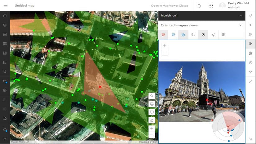
What qualifies a photo as oriented imagery is the metadata (parameters) associated with it. The metadata includes the exact location from which the photo was taken, the heading of the photo, the camera roll and pitch angles as well some other optical characteristics of the photo . When a photo has this metadata we can better understand not only where the photo was taken but also the geographic area (footprint) that is represented in the photo. You can then interrogate the photo for information:
- Find photos depicting a location
- Visualize the geographic footprint of a photo
- Highlight a location in a photo and see the geographic location (and vice versa)
QuickCapture has a built-in capability to collect oriented imagery and store the necessary metadata. You can enable oriented imagery in your existing QuickCapture projects through the web designer. See the blog post “Oriented imagery meets field data collection”.
Public QuickCapture Projects
To create a public QuickCapture project for crowdsourcing, citizen-science and community engagement initiatives, it is required that the ArcGIS Online organization has a license for ArcGIS Hub Premium. Public QuickCapture projects can be downloaded into the mobile app without the need to login with an ArcGIS account. See this article to learn how the Surfrider foundation used QuickCapture to help cleanup California beaches.
Here are the basics steps:
- If your ArcGIS Online organization is licensed with ArcGIS Hub Premium, the sharing dialog within the QuickCapture designer unlocks the share with Everyone option.
- When the project is shared with Everyone, you will need to distribute your project’s link or QR code for people to download it and use it. You can share the link in many ways; including social media, a website and email campaigns.
Working with ArcGIS Enterprise
QuickCapture is supported on all currently supported versions of ArcGIS Enterprise (10.7.1, 10.8.1, 10.9 and later). This includes using both feature services connecting to enterprise geodatabases as well as the hosted data store.
Final Words
Thank you to those of you that attended and to those who are watching later, we hope you enjoy! If you would like to learn more about the enhancements made to ArcGIS QuickCapture in the March 2024 release, read this blog. Check out the blogs below for more information on ArcGIS QuickCapture.


Commenting is not enabled for this article.