What decision should we make?
Is this the right path?
What will the long-term impacts be?
When I led planning and design teams, these were just a few of the critical questions I often faced on network builds. Unfortunately, we sometimes merely acted – fingers crossed! – and made what turned out to be the wrong decision. On more than one occasion, we found ourselves unable to serve an area, lacking redundancy, or in one of many other potentially limiting situations.
However, as I learned more about the capabilities of our comprehensive GIS, ArcGIS, I realized we had everything we needed to make the best decision possible. What we needed though, was a shift in our way of thinking to an ideology Richard Saul Wurman introduced roughly a decade ago. We needed to adopt a mindset of “understanding precedes action.”
Telecoms around the world are looking to improve their effectiveness and operational efficiency, often through better management of time. Time, if not properly managed, serves as a silent roadblock to success for any organization. When time is mismanaged, it will frustrate and alienate teams, prevent projects from being completed on time, serve as an unstable platform for decision-making, erode consumer confidence, and create unnecessary technical debt throughout your organization. However, one of the single greatest methods of effective time management is to foster a culture where “understanding precedes action.” When this happens, you create an environment where time is properly managed through better decision-making, and your organization gains power and momentum toward reaching your goals.
Wrong direction
Regardless of the size or complexity of a goal, you must take the first step to achieve it. In my experience, that’s a 100% true statement, but I also have learned that the shortest path to the goal is by ensuring those steps are in the right direction.
Let’s talk about a few ways Telecoms can better understand their operational environment before taking action and maximize their ability to leverage their most valuable resource – time.
Throughout my career in Telecom, my team and I occasionally found ourselves too far down a path toward an unintended destination. This usually required drastic measures to get the project back on track so we could meet our goals. Unfortunately, there were times where no course of action could be taken, and the project had to be abandoned due to the cost to correct or the window of opportunity passed. When these issues happened, one thing was a constant, we wasted valuable time.
To make it worse, when we discovered ourselves too far down the wrong path, it had a ripple effect on everything we did within our organization. Whether the situation was a new build project we were informed of too late and there was no fiber to get there, a lack of critical redlining updates available to design teams leading improper designs and delays in construction or permitting, or prolonged outage and restoration times due to lack of real-time information availability for field teams, it always impacted the rest of the work in our queues. Ultimately, the decisions we made were based on an incomplete view of the status of our network and operations and led to the organization mismanaging time by making bad decisions.
On the other hand, we were at our best and seemingly unstoppable when we had the information needed to make informed, intelligent, decisions.
Gain insight
To achieve any goal requires taking the first step to get there. To ensure the first step is in the right direction we need to gain understanding. This understanding, known also as situational awareness, comes in many forms and can be gained rather quickly. By doing so, you not only help teams utilize their time effectively through improved decision-making capability, but also provide a foundation for clear and concise communications and allow for effective collaboration across the organization.
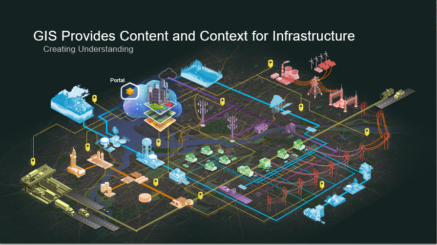
So, how do we gain this insight? ArcGIS, it’s is a comprehensive GIS like no other. It serves as a comprehensive ecosystem consisting of a System of Record, System of Insight, and System of Engagement. ArcGIS provides an organization a wide variety of resources, tools, applications, and solutions to help solve many organization challenges. Integrating and organizing your existing data and information, such as network designs, customer records, construction project records, city and landscape assets, and more, you turn your GIS into a powerful foundation supporting your organization.
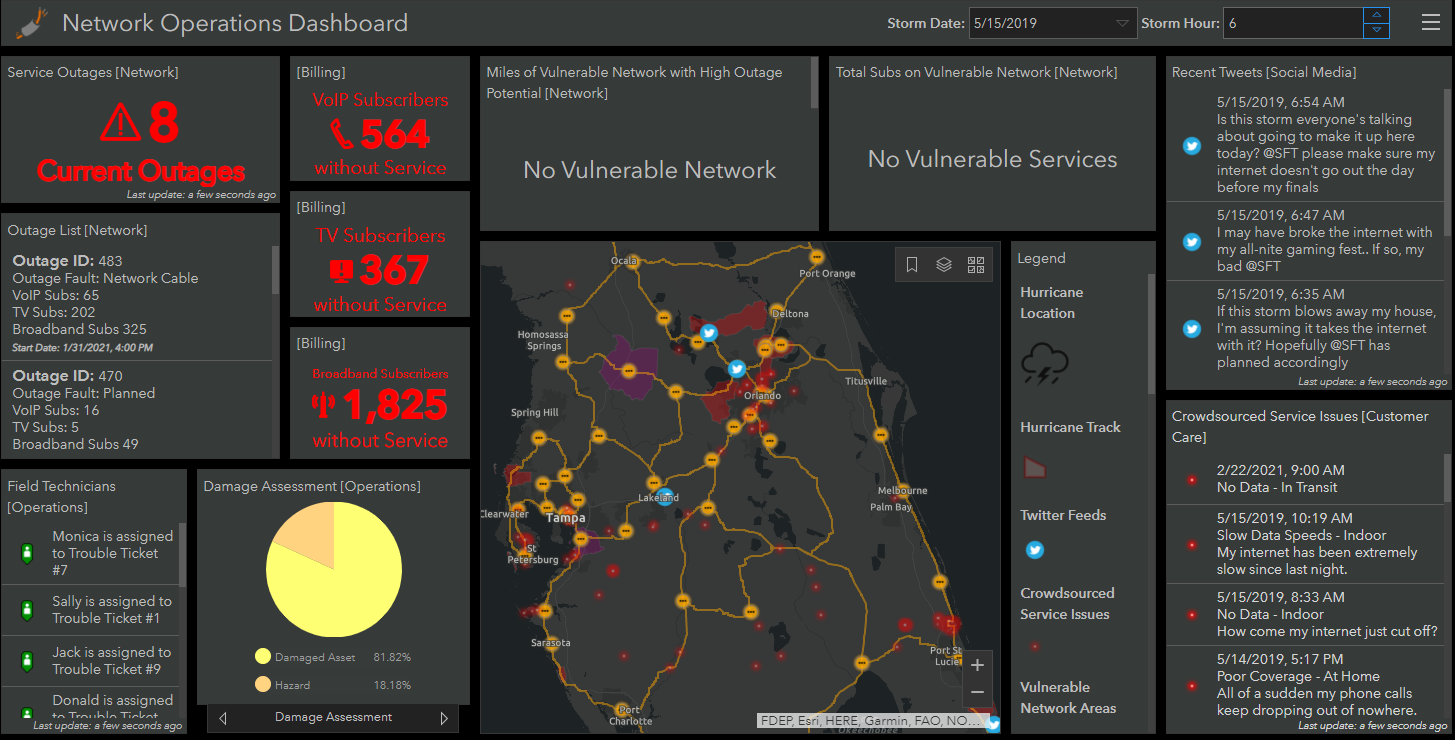
For instance, with that powerful foundation in ArcGIS, Telecoms can utilize dashboards and web apps to make better decisions, take appropriate action, and avoid wasting time. Teams can configure and utilize tools providing critical decision-making information like real-time status and health of network performance, region-wide project locations and implementation timelines, probability of accuracy of maps or database information, or as-built or map updates, and the average time to update. Furthermore, teams can integrate, utilize, and reference other information models such as buildings, landscape, other utility networks, and city information during the decision-making process. With views like this, teams feel confident in the decisions they make toward future actions.
Additionally, keeping systems up to date is simpler than it may sound. Through leveraging applications such as ArcGIS Field Maps, teams working remotely can access and utilize critical information such as fiber optic splice records, essential asset locations and information, or designed signal levels. When updates need to be made, or teams need to call out hazardous sites or dangerous situations, they can remotely reference and update key information and seamlessly provide this information to the rest of the organization in real-time.
Analyze and model
Tackling the needs of tomorrow’s NextGen networks does not have to be a complicated process filled with uncertainty, and your team doesn’t have to waste time making uninformed decisions. Today, through leveraging ArcGIS, Telecoms can utilize AI and Machine Learning to analyze and create models providing insight into what tomorrow’s marketplace and demands will look like. Telecoms can analyze their fiber network and gain insight into key details for every span, buffer tube, and individual fiber, while assessing critical aspects like their utilization state, fiber count continuity from end of line to the central office, and areas where redundancy does not exist.
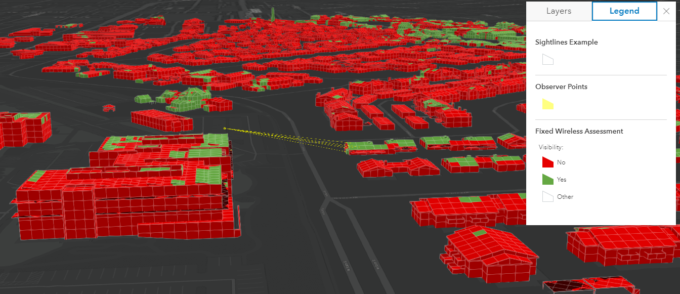
With this kind of insight, planning and design teams can model the impact of current projects on their network, but more importantly they can model and analyze the impacts of future needs like regional consumer growth, additional network monitoring IoT and sensor devices, and forecasted bandwidth consumption. This forecast and insight provides organizations the capability to create strategies for turning potential roadblocks, challenges, or problems into simple tasks to be addressed.
Telecom teams working within a culture of understanding precedes action, built upon a foundation of ArcGIS, experience improved work practices and best leverage their greatest asset – time. They gain real-time knowledge for analyzing and modeling what it will take to address the NextGen network needs of tomorrow and prevent their teams from going too far down the wrong path.