Nashville Electric Service (NES) is one of the 12 largest public electric utilities in the United States. Since 1939, NES has served as the primary electric provider for the Middle Tennessee region, distributing power to nearly 460,000 customers across a 700-square-mile territory. This coverage includes Nashville and Davidson County and portions of six surrounding counties. NES maintains over 5,900 miles of transmission and distribution lines and is committed to providing reliable, affordable power to a growing metropolitan region.
CHALLENGE
NES faced significant challenges in assessing and tracking storm damage. The lack of a single storm damage practice led to longer and inefficient restoration. Staff spent considerable time reconciling data from multiple sources, often resulting in redundant field checks and inconsistent data on work progress. This inefficiency also made it challenging to accurately assign contractors for post-storm repair checks and gather the necessary information for FEMA storm cost recovery.
“We need to get assessment crews assigned quickly to the circuits we believe are most damaged after a storm. However, assessing and tracking storm damage proved time-consuming, inefficient, and error-prone. Staff knew they also consumed unnecessary time on duplicate field checks.” – John Savary, NES Technical Lead.
An average storm involving three to four days of assessment required numerous hours across multiple departments to reconcile data from disparate sources. After the storm, even more time was typically spent tracking information supporting FEMA cost recovery. And that doesn’t include the untold hours wasted on duplicate field checks.
In recent years, increasingly frequent and severe storms have placed new demands on NES’s restoration operations. Assessing storm-related damage quickly and accurately is essential to mobilizing crews and restoring power, yet NES lacked a single, integrated system of record to manage the process. NES needed a streamlined solution—one that was built around their existing ArcGIS ecosystem—to improve visibility, coordination, and speed.
SOLUTION
To solve these challenges, NES expanded its use of ArcGIS as the central system of record for storm damage assessment and integrated the EpochField Work Management solution. This combined solution enabled NES to enable seamless, real-time communication between field assessment teams and engineering management.
The integrated ArcGIS and Epoch solution provided a centralized repository for storm damage data, streamlining the process of assessing and tracking damage, enabling faster deployment of damage assessment crews, and reducing redundant field checks.
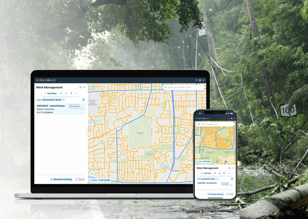
The integrated ArcGIS and EpochField provide a seamless view from the office and the field.
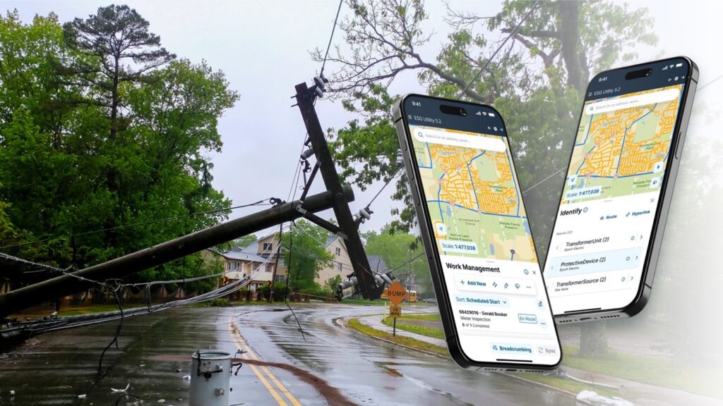
Damage assessors now perform inspections using mobile GIS apps, leveraging the power of ArcGIS to trace circuits, collect structured storm damage data, and attach georeferenced photos. The information is displayed in live ArcGIS Dashboards, allowing operations teams to monitor progress, prioritize repairs, and dynamically reassign crews within a shared, map-based interface.
ArcGIS and EpochField support circuit-level detail and overlay outage and customer call data to help NES predict where damage occurs. This technology enhances NES’s ability to deploy resources faster and more strategically. Field teams can also operate offline during major storm events, continuing to collect data without internet connectivity.
“We’re no longer wasting time reconciling spreadsheets or re-checking the same circuit. Everyone’s working off the same map.”—John Savary, Technical Lead, NES.
RESULTS
NES was able to centralize storm damage assessment, streamline data capture in the field, and significantly reduce operational inefficiencies around the damage assessment process. This approach improved pre-storm planning, allowing NES to organize and assign resources by circuits before an event. The solution provided:
- A single, centralized location for all storm damage data
- Advanced resource assignment and reduced preparation time for pre-storm planning
- Field crews can trace circuits to identify and prioritize damage.
- Field crews can quickly note completed work, reducing manual data entry.
- The operations team can dynamically reassign assessors and monitor overall progress.
PARTNER
In addition to implementing EpochField, NES worked closely with Epoch Solutions Group, whose technical expertise helped ensure that all mobile and web mapping workflows were fully aligned with NES’s ArcGIS architecture.
“The integration of ArcGIS with EpochField allows us to organize resources efficiently, track progress in the office and the field, deploy crews faster, inventory repaired equipment more accurately with less effort, and supply all our field users with our GIS maps. Now, we can all be on the same page during and after a storm.” – John Savary, Technical Lead, NES.
BENEFITS
The implementation significantly improved field damage collection and worker safety. It reduced staff time spent on data reconciliation and enhanced data quality, supporting decision-making. The offline access feature ensures that field crews can continue their work even when disconnected from internet connectivity, increasing productivity.
NES has seen dramatic improvements in operational efficiency for field assessments. The utility now saves the hours previously spent per storm by eliminating redundant data reconciliation and duplicate field checks. Additionally, NES saved hours per event on FEMA documentation, thanks to structured, GIS-based data capture.

Rapid damage assessment allows for faster restoration.
Moving to a GIS-centric storm damage assessment framework has positioned NES to meet future challenges with speed, agility, and confidence. Key benefits include:
- A single system of record for storm-related asset damage
- Real-time situational awareness using dashboards and live maps
- Offline capability for remote field crews
- Data-driven crew assignments with map-based clarity
- Faster, more accurate reporting for storm cost recovery
“The integration of ArcGIS and EpochField has become central to organizing, responding, and reporting during major events. It’s changing our storm response culture.”—John Savary, Technical Lead, NES.
On-site damage assessment improves efficiency and performance.
NEXT STEPS
NES plans to extend its ArcGIS-centric workflows into other field and operational programs. These include:
- Vegetation management scheduling and tracking
- Tennessee One-Call integration for storm restoration
- Pole inspection programs
- As-built field verification for design workflows
With its GIS infrastructure now in place, NES is focused on scaling its use of ArcGIS Enterprise and further optimizing its storm readiness planning.

