In the ever-evolving world of public health and healthcare, where data is as crucial as the treatments provided, Geographic Information Systems (GIS) have emerged as pivotal tools. But, with great power comes great responsibility – particularly in protecting patient privacy. Today, we formally introduce two new tutorials from our health-focused GIS curriculum that were developed to help you learn best practices for safeguarding sensitive personal data.
Protecting Patient Data when Geocoding
The first tutorial, “Protect Patient Data when Geocoding,” is a critical lesson for any health organization venturing into GIS. Geocoding – converting addresses into geographic coordinates – is foundational to any effort aimed at understanding spatial patterns in health data. That said, address data when combined with health information falls under the purview of health privacy laws. In that situation, great care must be exercised. This tutorial will help you determine when to exercise such caution in geocoding and offers a step-by-step guide on how to geocode patient data while adhering to strict confidentiality protocols. You’ll learn different tools and techniques so that no matter how you choose to geocode your data in the ArcGIS system, you can ensure that sensitive information remains secure.

De-identify Health Data for Visualization and Sharing
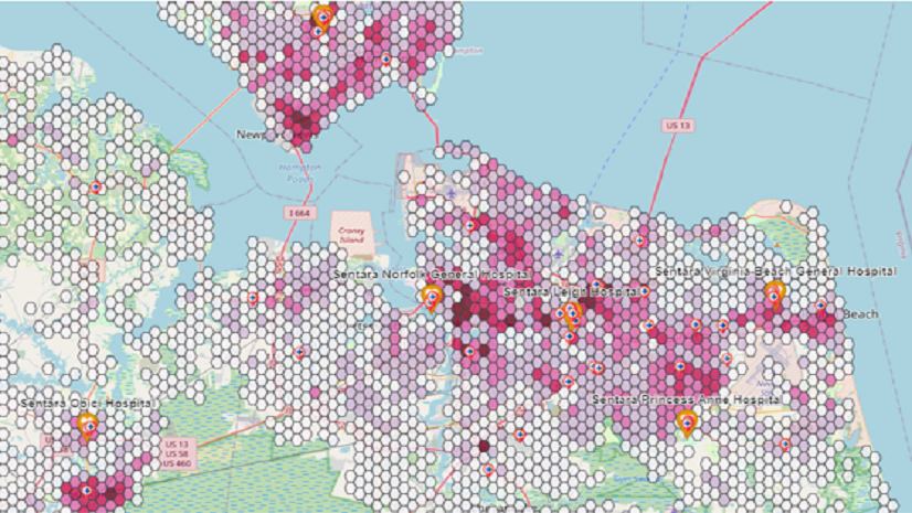
The second tutorial, “De-identify Health Data for Visualization and Sharing,” addresses another facet of data privacy – de-identification. As health organizations increasingly share data and maps for research, planning, and policy development, the risk of exposing personal health information escalates. This lesson provides strategies for de-identifying data, using statistical methods to ensure a “very low risk” of re-identification (the terminology stated in the Health Insurance Portability and Accountability Act (HIPAA) of 1996). Some of the options covered in detail include heat maps, point clustering, hot spot analysis, coordinate rounding, and different forms of aggregation across both space and time. Additionally, the tutorial touches upon advanced methods, ensuring a thorough understanding of effective data de-identification techniques. By applying these techniques, health professionals can share valuable data and insights without compromising patient privacy.

Importance for Health Organizations
As you know, data breaches can have catastrophic consequences, particularly in the health sector where trust is paramount. These tutorials therefore go beyond education and skills building. They are also fundamental in building a framework of trust and ethical practice in health data management. For health organizations, mastering these skills is not optional but essential. They ensure compliance with legal standards like HIPAA in the United States and can protect your organization’s reputation for safeguarding patient privacy.
We believe that the intersection of GIS and healthcare is a frontier of immense potential. That potential is greatest when we can safely work with data at the most local scales. As we navigate this terrain, the responsibility to protect the individuals behind the data is vital. These tutorials from our health-focused GIS curriculum are more than technical guides; they are also a part of moving us toward a future where data empowers and protects in equal measure.
As we continue to harness the power of GIS in health, let us do so with a commitment to privacy and ethical responsibility. These tutorials are just the beginning of a journey toward a more secure, informed, and compassionate healthcare system.