ArcGIS Blog

Imagery & Remote Sensing

ArcGIS Online

Dev Summit 2021: Analyze burn impact and severity

By Sara Sanchez and Vinay Viswambharan

The ability to host and analyze imagery data is vital to the work of many organizations. To demonstrate these workflows in action, Vinay walks through an overview of ArcGIS Image for ArcGIS Online(coming this summer) to explore its hosted imagery capabilities along with visualization and advanced raster analytics in the cloud. If you’ve already used or are familiar with these workflows in ArcGIS Enterprise, you’ll know how excited we are to announce they’ll soon be available to ArcGIS Online as well. 

In this analysis, Vinay studies the impact and severity of fire incidents across California last year where approximately 10,000 fire incidents burned 4.3 million acres across the state. He’s using a collection of ten satellite images that cover roughly 3,000 square miles of southern California near Santa Rosa. Up until now, he’s stored the images on his local machine. Using ArcGIS Image, he shows how to seamlessly host and analyze this imagery in ArcGIS Online

 Here are the steps he follows: 

  1. From My Content, click Create
  2. Select Create Imagery Layer
  3. Choose an Image Collection and specify the raster type to describe the imagery
  4. Optionally specify additional properties and parameters such as processing templates
  5. Drag and drop the imagery files and corresponding metadata
  6. Provide a title, description, and tags
  7. Create the Imagery Layer 

Once the imagery layer is in place, he’s ready to begin his analysis using a series of raster functions. He accesses the function editor  where more than 150 raster functions are available. Raster functions can be chained together to create custom analytical workflows and shared across the organization.

Vinay uses a pre-created burn severity template to evaluate his hosted imagery. He sets parameters and runs the analysis. Once the tool runs, results are added to the map and show high burn severity areas in orange. 

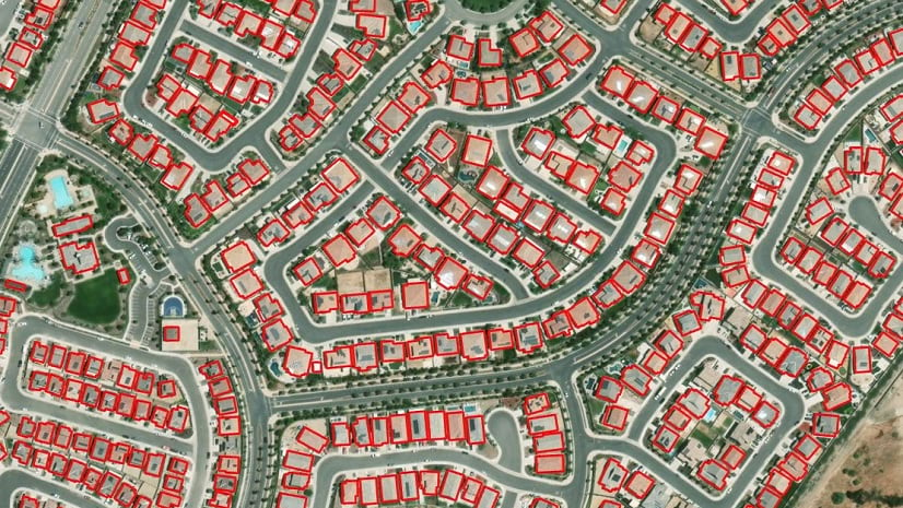
Next, he wants to determine how many structures are found in the high severity areas. As he doesn’t yet have building footprints already mapped for the area, Vinay leverages new deep learning capabilities to extract building footprints.  From the Raster analysis tools pane, Vinayexpands the Deep Learning section and selects the Detect Objects using Deep Learning tool 

In setting the parameters of the model, he first specifies for the tool to run against Airbus high-resolution imagery. Next, he selects a building footprints extraction model from ArcGIS Living Atlas of the World. 

Once Vinay runs the model, his results are added to the map. The model was successfully able to extract the building footprints from the high-resolution imagery. After matching up the building footprints with the burn severity areas, he’s able to determine that 1,500 structures, shown in blue, are within the burn perimeter. 

This was just one scenario for using ArcGIS Image to host large imagery and perform advanced raster analysis in ArcGIS OnlineWe’re excited to see what problems you tackle with this new capability! 

Learn more:

Share this article

Subscribe
Notify of
0 Comments
Oldest
Newest
Inline Feedbacks
View all comments
Julie Kottamala(@julie-kottamalaraleighnc-gov_ral)
January 7, 2022 6:54 am

Hey Sean,
This is exciting. Do you know when it’ll be available on the Government tenant? It doesn’t show up in my flow yet. Thanks- Julie

Rudolf de(@rdemunnikesri_southafrica-com_one_esri)
January 10, 2022 5:42 am

Hi Sean, Thank you for the blog post – exciting functionality. I just have two questions. 1. I started testing the ArcGIS Power Automate connectors, but realized that they require a “Premium” Power Automate subscription. I cannot use it like I can use Survey123 in the free Power Automate? 2. The method to connect to “Get Geometry from a layer”, Can i use any polygon, line or point feature services in my organization OR am i limited to the boundaries available from the “Location Types” in the ArcGIS for Power BI Visualizer, because i see that one of the mandatory… Read more »

Michal Gasparovic(@michal-gasparovicbhp-com_bhp)
January 23, 2022 4:08 pm

Interesting, yet I don’t understand why there is no direct connector in PowerBI that would also support ArcGIS Enterprise Portals. I’ve written the custom connector myself that does allow you to connect to AGOL or Portal via OAuth2.0, does the token refresh and runs the query against the FL REST API along with pagination (if maxResults limits the response)…

Not everyone wants to be pulling the data using the connectors in Power Automate…

Michal Gasparovic(@michal-gasparovicbhp-com_bhp)
January 23, 2022 4:10 pm

sorry, what I’d welcome would be a simple REST API Query connector where users would (in its simplest form) query the data via url that can obtain in REST API … Thanks

Janella Flook(@jkflook)
March 22, 2022 11:08 am

I have made several cloud flows in PA for to my survey123 forms. When testing a flow, they appear to work and send an 365 email, but then stop working when survey’s are submitted? Last Fri, one flow just starting working and sending emails… on Monday that same flow has not responded? Any thoughts?

Shawn Smith(@smsmet_bpuspl)
June 9, 2022 12:07 pm

Does this connector with Enterprise or just Online?

Shawn Smith(@smsmet_bpuspl)
June 30, 2022 8:07 am
Reply to  Sean McGinnis

Thank you. have any clue when release date is?

Shawn Smith(@smsmet_bpuspl)
June 30, 2022 11:50 am
Reply to  Sean McGinnis

Thanks, Sean, do you know anything about error message when using custom connector, ‘cannot add more than 1024 properties in the webhook payload?

Priya Rathi(@cdc-cgh-obms)
July 22, 2022 7:27 am

We are trying to use ArcGIS “Find Address Candidates” connector at CDC. We tried using both ArcGIS and ArcGIS PasS with “No Stored” option. Both results in “Token is valid but access is denied”. With the same token/login details we can make direct rest API call. Any idea why we might be getting access denied?

Michael Walker(@mwalkerdover)
December 2, 2022 5:43 am

I have a workflow that is using Power Automate connector with ArcGIS Enterprise to send emails with a completed Survey123. After working out great for free with our Microsoft Office suite license for about 5 months, Microsoft is now saying this is a Premium connector. Is this correct? If correct this is a big blow to my workflow. Can this be?!?

Susana Gasquez(@susana-gasquezeu-jll-com_jll)
January 31, 2023 6:00 am

Hi there, i am new at using Power Automate with Survey123 and was wondering whether it was possible to create a flow that will email someone specific depending on a choice from the survey (e.g. if I choose from drop-down: property type: office, then email person A, if I choose property type: Shop, email person B, else, email person C). when checking the flows in can see the condition option, but receive the following error: ActionBranchingConditionNotSatisfied. The execution of the template action ‘Send_an_email_(V2)’ skipped… anything that i should consider, any good resource go get best practice advice on how to… Read more »

Jane Hogben(@janehogben)
May 9, 2023 1:07 am

Hi Sean, thanks for the article. Can you provide an update as to whether this now works with AG Enterprise?

Last edited 2 years ago by Jane Hogben
Paul Giroux(@gsu-paul-giroux)
November 16, 2023 9:25 am

Sean: I’m watching #MSIgnite and wondering if the connectors work with MS Copilot. Would be great if we could create our own Copilots for Teams using Copilot Studio that integrate with our Enterprise or AGO rest and other systems so people could use natural language in Teams to ask questions and get answers from the data.

Last edited 1 year ago by Paul Giroux