ArcGIS Field Maps is a powerful all-in-one mobile app solution used to complete field work faster, more efficiently, and more accurately.
Field Maps is used to explore maps, collect and update authoritative data, and record and share where mobile workers have gone in a single, location-aware mobile app. Using the Field Maps web app included with ArcGIS Online and ArcGIS Enterprise, GIS analysts configure maps, forms, and app settings to provide a focused experience for their mobile workforce.
Contingent Values
The May 2022 release of Field Maps introduces support for contingent values. Contingent values are commonly used to model natural classifications (trees, plants, wildlife) or material classifications for assets (poles, pipes) and can dramatically improve the efficiency and accuracy of form data capture in ArcGIS Field Maps.
Contingent values, created and managed using ArcGIS Pro, allow you to define valid field values that are dependent on values in other fields. Fields that are contingent to one another are referred to as a field group. When a field group is included in a form, mobile workers are presented with a list of valid values for each field that are contingent to a field they previously filled out.
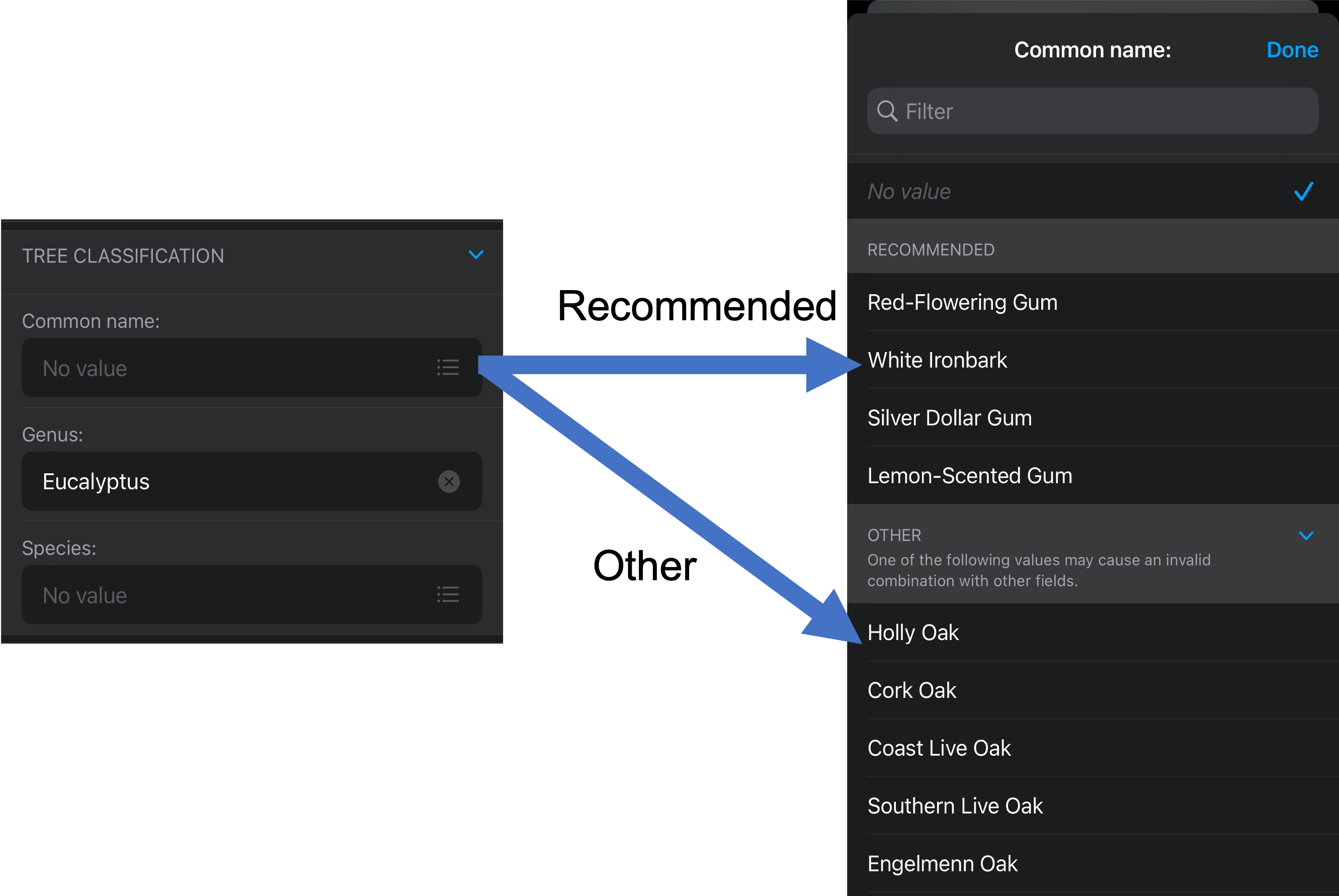
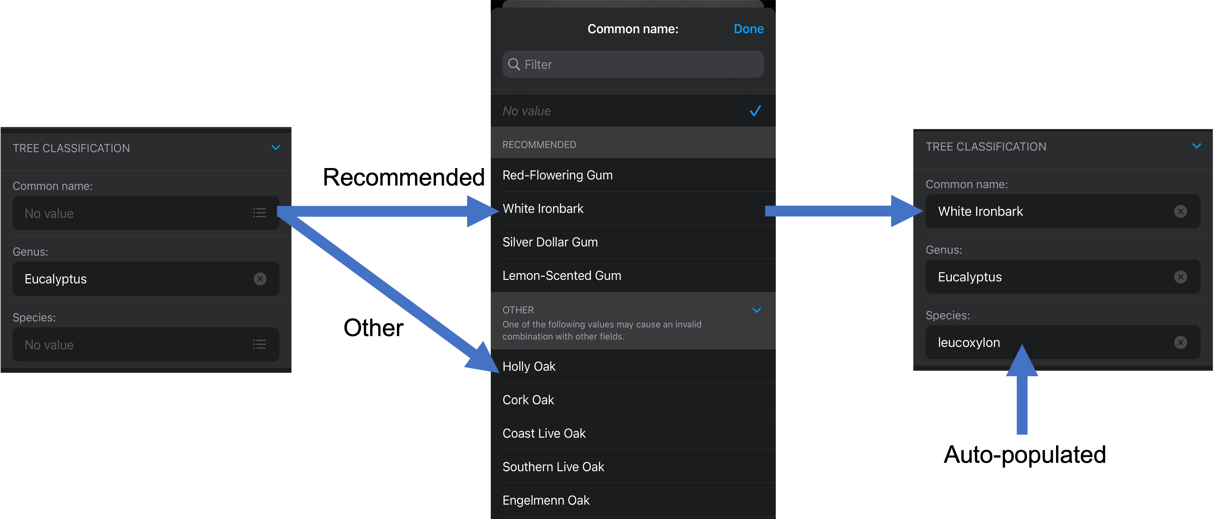
Consider a field group with input types for the common name, genus and species classification of trees. When a genus is chosen (Eucalyptus for example) the list of valid options for the Common Name field are automatically populated and listed under the Recommended section. All other values in the last are available in the Other section.

If you select one or more values in a field group (White Ironbark for example), and the remaining fields in the group contain only one Recommended value, those remaining fields will be filled in automatically.

For more information about what’s new in the May release, please read the What’s New topic in our documentation.
What’s Next
We’re planning an update to ArcGIS Workforce that will be coming this month. This update to the Android and iOS apps will include support for auto-sync when the app is in the background along with several quality improvements. We’re also busy planning the integration of Workforce planning capabilities into ArcGIS Field Maps as well.
We are planning to release the following capabilities in our June update to ArcGIS Field Maps:
- GPS metadata for line and polygon features – with this update fields for the average and worst horizontal and vertical accuracy, the worst fix type used, and the number of manual locations will be captured for line and polygon features. We’ll also capture the full GPS metadata for each vertex.
- Geotriggers – use Geotriggers to improve operational awareness (connected or offline). Map authors can use the Field Maps web app to configure geotriggers that notify mobile workers and/or start and stop location tracking when entering or exiting a location. Geotriggers are now in beta.
- Utility Networks – initial support for connected network tracing, view of connectivity and structural assessment associations, and containment:
- Network tracing – Within ArcGIS Pro, you can configure a trace and provide network tracing capabilities to your mobile workforce using a named trace configuration. Named Trace Configurations contain all the parameters of a trace and hide the complexity from the mobile worker. Each map can have a set of named trace configurations shared with it and any named trace configuration shared will show up when that map is used in Field Maps when a network element is selected.
- Connectivity and Structural Attachment Associations – Field Maps is the ideal mobile app for viewing a utility network. Distribution networks include a lot of map layers, and grouping layers together so that you can work with them effectively on a mobile device is critical. When a map includes a utility network, Field Maps becomes aware of the network and you can discover additional ways to visualize the content within your network. Opening the Layers tool, you will see a section titled NETWORK LAYERS where you can turn on/off visualization of network connections and attachments.
- Containment – Containment is an association relationship in the Utility Network. When you select a feature which acts as a container in the Utility Network, the View Contents feature action will be visible in the panel which appears when a feature is selected and will provide the number of contained elements. Tapping on the feature action, you can drill down and select each individual element and access its details.
- Indoor positioning and editing – with the December update, we updated Field Maps support for floor-aware maps to match the latest release of the ArcGIS Indoors geodatabase. Next, we will add support for indoor positioning and editing.


Hi Jeff – Exciting added functionality for utilities in the latest releases. Are there any plans to make updates available to the Field Maps web app for Enterprise 10.9.1? We are trying to understand how we can take advantage of the latest functionality and changes geared for utilities in the Field Maps web app but also stay on a UN Network Management Release of Enterprise.